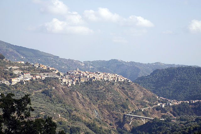
Carlopoli (Carlopoli)
.svg)
- Italian comune
 Hiking in Carlopoli
Carlopoli is a quaint village located in the Calabria region of southern Italy, offering several opportunities for hiking and enjoying the natural beauty of the area. The surrounding landscape is characterized by mountainous terrain, lush forests, and breathtaking views. Here are some highlights for hiking in and around Carlopoli:
1.
- Nature Trails: The area around Carlopoli features various trails that take you through picturesque landscapes, including hills and valleys, with rich flora and fauna. Be sure to look for local wildlife, including birds and other creatures native to the region.
- Historical Pathways: Some trails might lead you to historical sites, giving you a glimpse into the past of the area, including ancient ruins or old village paths.
2.
- Trails near Carlopoli can range in difficulty from easy walks suitable for families to more challenging hikes that require a good level of fitness. Be sure to choose a trail that matches your experience and fitness level.
3.
- The ideal time for hiking in Carlopoli is during the spring and autumn months when the weather is mild and the scenery is especially vibrant. Summer can be hot, so it’s best to hike in the early morning or late afternoon.
4.
- Consider hiring a local guide if you want to learn more about the area’s natural and cultural history. They can help navigate the trails and ensure you have a safe and enjoyable experience.
5.
- Wear sturdy hiking boots for traction and support, and dress in layers to adapt to changing temperatures. Don’t forget to bring plenty of water, snacks, and a first-aid kit.
6.
- While in Carlopoli, take the time to explore the village itself, which features charming architecture and local cuisine. Engaging with the community and learning about their culture can enhance your hiking experience.
7.
- Always check the local weather conditions before heading out, inform someone about your hiking plans, and carry a map or GPS device. Cell phone service may be limited in remote areas.
Hiking in Carlopoli offers a wonderful blend of outdoor adventure, scenic beauty, and cultural immersion, making it a unique destination for hikers and outdoor enthusiasts.
- Country:

- Postal Code: 88040
- Local Dialing Code: 0968
- Licence Plate Code: CZ
- Coordinates: 39° 3' 0" N, 16° 27' 0" E


- GPS tracks (wikiloc): [Link]
- AboveSeaLevel: 924 м m
- Area: 16.41 sq km
- Population: 1525
- Web site: http://www.comune.carlopoli.cz.it
- Wikipedia en: wiki(en)
- Wikipedia: wiki(it)
- Wikidata storage: Wikidata: Q53504
- Wikipedia Commons Category: [Link]
- Freebase ID: [/m/0fh4jw]
- GeoNames ID: Alt: [6539074]
- VIAF ID: Alt: [235230403]
- OSM relation ID: [39781]
- GND ID: Alt: [4644445-2]
- ISTAT ID: 079020
- Italian cadastre code: B790
Shares border with regions:

Cicala
- Italian comune
Hiking in Cicala
Cicala is a charming destination for hiking enthusiasts, located in the Calabria region of Italy. Its picturesque landscapes, rich biodiversity, and breathtaking views make it a great place for outdoor activities. Here are some key aspects to consider when hiking in Cicala:...
- Country:
- Postal Code: 88040
- Local Dialing Code: 0968
- Licence Plate Code: CZ
- Coordinates: 39° 1' 20" N, 16° 29' 10" E
- GPS tracks (wikiloc): [Link]
- AboveSeaLevel: 837 м m
- Area: 9.28 sq km
- Population: 952
- Web site: [Link]
Gimigliano
- Italian comune
Hiking in Gimigliano
Gimigliano is a small but charming town in the Calabria region of southern Italy, known for its picturesque landscapes and proximity to the Sila National Park, which offers stunning hiking opportunities. Here are some insights about hiking in and around Gimigliano:...
- Country:
- Postal Code: 88045
- Local Dialing Code: 0961
- Licence Plate Code: CZ
- Coordinates: 38° 58' 0" N, 16° 32' 0" E
- GPS tracks (wikiloc): [Link]
- AboveSeaLevel: 600 м m
- Area: 33.55 sq km
- Population: 3292
- Web site: [Link]

Soveria Mannelli
- Italian comune
Hiking in Soveria Mannelli
Soveria Mannelli is a charming town located in the Calabria region of southern Italy, known for its stunning landscapes, rich history, and outdoor activities, including hiking. Nestled in the Sila National Park, this area offers a variety of trails that cater to different skill levels....
- Country:
- Postal Code: 88049
- Local Dialing Code: 0968
- Licence Plate Code: CZ
- Coordinates: 39° 5' 0" N, 16° 22' 0" E
- GPS tracks (wikiloc): [Link]
- AboveSeaLevel: 774 м m
- Area: 20.5 sq km
- Population: 3034
- Web site: [Link]
Sorbo San Basile
- Italian comune
Hiking in Sorbo San Basile
Sorbo San Basile is a charming town located in the Calabria region of Southern Italy, surrounded by the breathtaking natural beauty of the Sila Mountains. Hiking in this area offers a unique experience, characterized by stunning landscapes, diverse ecosystems, and rich local culture. Here are some highlights and tips for hiking in and around Sorbo San Basile:...
- Country:
- Postal Code: 88050
- Local Dialing Code: 0961
- Licence Plate Code: CZ
- Coordinates: 39° 1' 0" N, 16° 34' 0" E
- GPS tracks (wikiloc): [Link]
- AboveSeaLevel: 605 м m
- Area: 59.28 sq km
- Population: 790
- Web site: [Link]
Bianchi, Calabria
- Italian comune
Hiking in Bianchi, Calabria
Hiking in Bianchi, a small town located in the Calabria region of southern Italy, offers a unique opportunity to explore the natural beauty and cultural heritage of the area. The town is situated in the Sila National Park, which boasts a variety of landscapes, including lush forests, rolling hills, and stunning mountain views....
- Country:
- Postal Code: 87050
- Local Dialing Code: 0984
- Licence Plate Code: CS
- Coordinates: 39° 6' 0" N, 16° 25' 0" E
- GPS tracks (wikiloc): [Link]
- AboveSeaLevel: 825 м m
- Area: 33.32 sq km
- Population: 1279
- Web site: [Link]
Panettieri
- Italian comune
Hiking in Panettieri
Panettieri is a small town in the Calabria region of southern Italy, located in the province of Cosenza. While it may not be a widely known hiking destination, the surrounding areas offer some stunning natural landscapes that are perfect for outdoor enthusiasts....
- Country:
- Postal Code: 87050
- Local Dialing Code: 0968
- Licence Plate Code: CS
- Coordinates: 39° 4' 0" N, 16° 27' 0" E
- GPS tracks (wikiloc): [Link]
- AboveSeaLevel: 937 м m
- Area: 14.67 sq km
- Population: 343
- Web site: [Link]