Castagnito (Castagnito)
- Italian comune
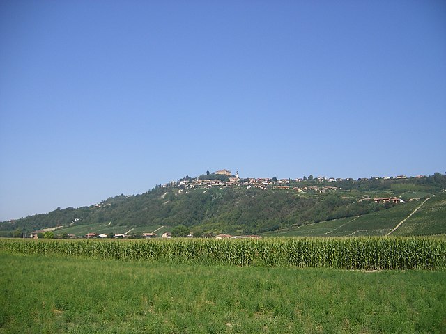
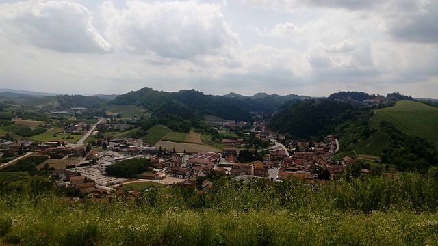
Castagnito, located in the Piedmont region of Italy, offers scenic trails and a rich natural environment perfect for hiking enthusiasts. Although it's a smaller hamlet, it is surrounded by beautiful landscapes and rolling hills typical of the area. Here are some key points to consider for a hiking experience in Castagnito:
Hiking Trails
- Local Trails: There are various local trails ranging from easy to moderate difficulty that offer views of vineyards, forests, and countryside.
- Nature Reserves: Nearby nature reserves or parks may provide more structured hiking paths, often with informative signs about local flora and fauna.
- Guided Tours: Look for guided hikes which can provide insight into the ecology and history of the area.
What to Expect
- Scenic Views: Expect picturesque views of the surrounding hills and valleys, especially during sunrise and sunset.
- Vineyards: The region is known for its wine production, so often trails will pass through or near vineyards, providing an opportunity for wine tasting post-hike.
- Wildlife Watching: Keep an eye out for local wildlife; the area is home to various birds and other animals.
Practical Tips
- Best Time to Hike: Spring and fall provide the best weather for hiking, with comfortable temperatures and beautiful scenery.
- Preparation: Make sure to wear sturdy hiking boots and clothing suitable for outdoor activities. Carry enough water, snacks, and perhaps a map or GPS.
- Local Regulations: Always check for any local regulations regarding trail use and ensure you're hiking in designated areas.
Cultural Experiences
- Local Cuisine: After a long hike, enjoy the regional cuisine in local eateries. Try the traditional dishes that the Piedmont region has to offer.
- Wine Tours: Consider pairing your hiking with wine tours in the nearby Langhe region, which is famous for its Barolo and Barbaresco wines.
Hiking in Castagnito can be a delightful experience, blending outdoor activity with the rich culture and beauty of the Piedmont region. Always make sure to stay safe and respect the natural environment while enjoying your hike!
- Country:

- Postal Code: 12050
- Local Dialing Code: 0173
- Licence Plate Code: CN
- Coordinates: 44° 45' 0" N, 8° 2' 0" E


- GPS tracks (wikiloc): [Link]
- AboveSeaLevel: 350 м m
- Area: 7.11 sq km
- Population: 2165
- Web site: http://www.comune.castagnito.cn.it
- Wikipedia en: wiki(en)
- Wikipedia: wiki(it)
- Wikidata storage: Wikidata: Q19890
- Wikipedia Commons Category: [Link]
- Freebase ID: [/m/0gb8lr]
- GeoNames ID: Alt: [6539564]
- OSM relation ID: [43552]
- UN/LOCODE: [ITCG2]
- ISTAT ID: 004046
- Italian cadastre code: C046
Shares border with regions:

Barbaresco
- Italian comune
Barbaresco, located in the Piedmont region of Italy, is well-known for its stunning landscapes, vineyards, and rich cultural heritage. Hiking in and around Barbaresco offers a unique opportunity to explore the rolling hills of the Langhe region, which is famous for its Nebbiolo wines, scenic vistas, and charming villages....
- Country:

- Postal Code: 12050
- Local Dialing Code: 0173
- Licence Plate Code: CN
- Coordinates: 44° 43' 0" N, 8° 5' 0" E


- GPS tracks (wikiloc): [Link]
- AboveSeaLevel: 274 м m
- Area: 7.76 sq km
- Population: 646
- Web site: [Link]

Castellinaldo
- Italian comune
Castellinaldo d'Alba is a charming village located in the Piedmont region of northern Italy, well-known for its picturesque landscapes and vineyards. Hiking in this area offers a unique blend of natural beauty, cultural heritage, and culinary delights, particularly the famous wines of the Barolo region. Here are some insights into hiking in Castellinaldo d'Alba:...
- Country:

- Postal Code: 12050
- Local Dialing Code: 0173
- Licence Plate Code: CN
- Coordinates: 44° 47' 0" N, 8° 2' 0" E


- GPS tracks (wikiloc): [Link]
- AboveSeaLevel: 285 м m
- Area: 7.8 sq km
- Population: 930
- Web site: [Link]

Guarene
- Italian comune
Guarene is a charming village located in the Piedmont region of Italy, specifically in the province of Cuneo. While it may not be as widely recognized as some of Italy's more famous hiking destinations, it offers beautiful landscapes and a picturesque setting for outdoor activities, including hiking. Here are some details to consider:...
- Country:

- Postal Code: 12050
- Local Dialing Code: 0173
- Licence Plate Code: CN
- Coordinates: 44° 44' 24" N, 8° 2' 7" E


- GPS tracks (wikiloc): [Link]
- AboveSeaLevel: 360 м m
- Area: 13.45 sq km
- Population: 3558
- Web site: [Link]
Magliano Alfieri
- Italian comune
Magliano Alfieri is a charming village located in the Piedmont region of northwestern Italy, surrounded by beautiful landscapes, vineyards, and rolling hills. Hiking in this area offers a mix of scenic views, cultural heritage, and a chance to explore the local flora and fauna....
- Country:

- Postal Code: 12050
- Local Dialing Code: 0173
- Licence Plate Code: CN
- Coordinates: 44° 46' 0" N, 8° 4' 0" E


- GPS tracks (wikiloc): [Link]
- AboveSeaLevel: 328 м m
- Area: 9.5 sq km
- Population: 2147
- Web site: [Link]

Neive
- Italian comune
Neive, a charming town in the Piedmont region of northwest Italy, is surrounded by beautiful landscapes perfect for hiking enthusiasts. This area is particularly known for its stunning vineyards, rolling hills, and picturesque scenery, which makes for a fantastic hiking experience....
- Country:

- Postal Code: 12052
- Local Dialing Code: 0173
- Licence Plate Code: CN
- Coordinates: 44° 43' 0" N, 8° 7' 0" E


- GPS tracks (wikiloc): [Link]
- AboveSeaLevel: 308 м m
- Area: 21.3 sq km
- Population: 3461
- Web site: [Link]

Vezza d'Alba
- Italian comune
Vezza d'Alba, located in the Piemonte region of northern Italy, offers a wonderful setting for hiking enthusiasts, thanks to its scenic landscapes, rolling hills, and proximity to the Langhe area, famous for its vineyards and gastronomy. Here are some highlights of hiking in and around Vezza d'Alba:...
- Country:

- Postal Code: 12040
- Local Dialing Code: 0173
- Licence Plate Code: CN
- Coordinates: 44° 46' 0" N, 8° 0' 0" E


- GPS tracks (wikiloc): [Link]
- AboveSeaLevel: 313 м m
- Area: 14.07 sq km
- Population: 2288
- Web site: [Link]
