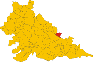
Castel d'Ario (Castel d'Ario)
- Italian comune
Castel d'Ario is a small town located in the province of Mantua, Italy. While it may not be widely known as a hiking destination, the surrounding areas offer beautiful landscapes and the opportunity for outdoor activities, including hiking.
Hiking Opportunities:
-
Nature Trails: The countryside around Castel d'Ario features various dirt paths and trails that can be explored. These trails might not be well-marked, but they provide a chance to experience the local flora and fauna.
-
Po Delta Park: A short drive from Castel d'Ario is the Po Delta Regional Park, which offers more structured hiking options. This park is known for its diverse ecosystems, including wetlands and agricultural landscapes, home to various bird species.
-
Mantuan Countryside: The Mantua region is flat and characterized by picturesque countryside, vineyards, and rice paddies. Walking or biking through these scenic areas can provide a serene hiking experience.
-
Cultural Routes: While hiking, you may also encounter historical sites and landmarks, such as rural churches and ancient towns. Incorporating some cultural exploration can enhance your hiking experience.
Practical Tips:
-
Equipment: Wear comfortable hiking shoes and bring water, snacks, and sun protection. Depending on the season, consider layering your clothing.
-
Navigation: Since some trails may not be well-marked, it can be helpful to carry a map or a GPS device.
-
Weather: Check the weather conditions before heading out, as they can vary widely, especially in spring and fall.
-
Local Guidance: If you're unsure about routes, consider reaching out to local hiking groups or guides who can provide insight into the best trails.
Conclusion
While Castel d'Ario isn't a major hiking hub, it offers lovely opportunities for those looking to enjoy a peaceful hike in a rural Italian setting. Exploring the nearby parks and countryside may lead to enjoyable adventures both in nature and culture.
- Country:

- Postal Code: 46033
- Local Dialing Code: 0376
- Licence Plate Code: MN
- Coordinates: 45° 11' 20" N, 10° 58' 32" E


- GPS tracks (wikiloc): [Link]
- AboveSeaLevel: 24 м m
- Area: 22.58 sq km
- Population: 4659
- Web site: http://www.comune.casteldario.mn.it/
- Wikipedia en: wiki(en)
- Wikipedia: wiki(it)
- Wikidata storage: Wikidata: Q42338
- Wikipedia Commons Category: [Link]
- Freebase ID: [/m/0gj_w5]
- GeoNames ID: Alt: [6536587]
- VIAF ID: Alt: [132989505]
- OSM relation ID: [44336]
- WOEID: [713208]
- UN/LOCODE: [ITDAX]
- ISTAT ID: 020014
- Italian cadastre code: C076
Shares border with regions:

Villimpenta
- Italian comune
Villimpenta is a small municipality located in the province of Mantua, in the Lombardy region of northern Italy. While it may not be a widely known hiking destination, the surrounding area offers scenic landscapes and a chance to experience nature in a more tranquil setting....
- Country:

- Postal Code: 46039
- Local Dialing Code: 0376
- Licence Plate Code: MN
- Coordinates: 45° 9' 0" N, 11° 2' 0" E


- GPS tracks (wikiloc): [Link]
- AboveSeaLevel: 18 м m
- Area: 14.85 sq km
- Population: 2167
- Web site: [Link]


Roncoferraro
- Italian comune
Roncoferraro is a small town located in the Lombardy region of northern Italy, near the city of Mantua. The area is known for its scenic landscapes, which can provide a lovely backdrop for hiking enthusiasts. While the town itself may not have extensive hiking trails, you can explore the surrounding countryside and waterways, offering a blend of natural beauty and cultural heritage....
- Country:

- Postal Code: 46037
- Local Dialing Code: 0376
- Licence Plate Code: MN
- Coordinates: 45° 8' 3" N, 10° 57' 9" E


- GPS tracks (wikiloc): [Link]
- AboveSeaLevel: 25 м m
- Area: 63.43 sq km
- Population: 6982
- Web site: [Link]
Sorgà
- Italian comune
Sorgà, located in the Veneto region of Italy, is a charming area known more for its agricultural landscape than for extensive hiking trails. However, there are opportunities for pleasant walks and hikes nearby. Here are some insights if you're looking to explore hiking around Sorgà:...
- Country:

- Postal Code: 37060
- Local Dialing Code: 045
- Licence Plate Code: VR
- Coordinates: 45° 13' 0" N, 10° 59' 0" E


- GPS tracks (wikiloc): [Link]
- AboveSeaLevel: 25 м m
- Area: 31.54 sq km
- Population: 3019
- Web site: [Link]

