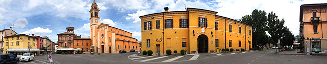
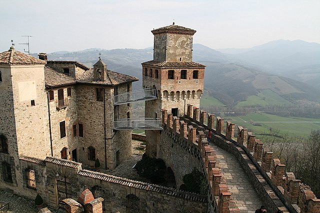
Castell'Arquato (Castell'Arquato)
.svg)
- Italian comune
 Hiking in Castell'Arquato
Castell'Arquato is a picturesque medieval village located in the Emilia-Romagna region of Italy, surrounded by rolling hills and stunning landscapes, making it a fantastic destination for hiking enthusiasts. The area around Castell'Arquato offers a variety of hiking trails that cater to different skill levels, from easy walks suitable for families to more challenging routes for experienced hikers.
Hiking Trails
-
Pathways through the Vineyards: Many trails meander through the vineyards that the region is famous for. These paths often offer beautiful views of the countryside, and you can learn about local wine production as you hike.
-
The Ghiara Trail: This trail provides an opportunity to explore the natural beauty of the surroundings and often features panoramic views of the valley below.
-
Forest Trails: There are also trails that wind through wooded areas, where you can enjoy the local flora and fauna, especially vibrant in spring and summer.
-
Heritage Walks: Some trails are integrated with historical routes, allowing hikers to experience the local culture and history, exploring ancient churches and ruins along the way.
Preparation and Tips
- Footwear: Ensure you wear sturdy hiking boots for good support, especially if you plan on tackling uneven or rocky terrain.
- Water and Snacks: Carry sufficient water and snacks to keep your energy up during your hike.
- Navigation: It can be helpful to have a map or a trail app to keep you oriented, as trail markers can vary in visibility.
- Weather: Check the weather forecast before heading out, as conditions can change rapidly in mountainous areas.
Best Seasons to Hike
- Spring (March to May): Ideal for wildflowers and mild temperatures.
- Fall (September to November): Offers beautiful autumn colors and a more pleasant hiking experience with cooler temperatures.
Local Attractions
While hiking in Castell'Arquato, you might also want to take some time to explore the village itself. The medieval architecture, including the Castle, the Collegiate Church of San Giovanni, and various viewpoints offer enriching experiences after a day on the trails.
In summary, hiking in Castell'Arquato provides not only physical activity and enjoyment of nature but also an opportunity to engage with the local culture and history of this enchanting region. Enjoy your adventure!
- Country:

- Postal Code: 29014
- Local Dialing Code: 0523
- Licence Plate Code: PC
- Coordinates: 44° 51' 0" N, 9° 52' 0" E


- GPS tracks (wikiloc): [Link]
- AboveSeaLevel: 224 м m
- Area: 52.75 sq km
- Population: 4621
- Web site: http://www.comune.castellarquato.pc.it/
- Wikipedia en: wiki(en)
- Wikipedia: wiki(it)
- Wikidata storage: Wikidata: Q102631
- Wikipedia Commons Gallery: [Link]
- Wikipedia Commons Category: [Link]
- Freebase ID: [/m/09wgvb]
- GeoNames ID: Alt: [6536333]
- VIAF ID: Alt: [138047926]
- OSM relation ID: [43739]
- MusicBrainz area ID: [ef0c5546-3af4-4174-8f61-9cf0ef31953b]
- UN/LOCODE: [ITZGV]
- ISTAT ID: 033012
- Italian cadastre code: C145
Shares border with regions:
Alseno
- Italian comune
Hiking in Alseno
Alseno, a charming town in the Emilia-Romagna region of Italy, is surrounded by beautiful landscapes that offer a variety of hiking opportunities. While Alseno itself is more rural and is known for its traditional Italian countryside charm, nearby areas provide access to scenic trails....
- Country:
- Postal Code: 29010
- Local Dialing Code: 0523
- Licence Plate Code: PC
- Coordinates: 44° 54' 0" N, 9° 58' 0" E
- GPS tracks (wikiloc): [Link]
- AboveSeaLevel: 79 м m
- Area: 55.27 sq km
- Population: 4695
- Web site: [Link]

Carpaneto Piacentino
- Italian comune
Hiking in Carpaneto Piacentino
Carpaneto Piacentino is a charming town located in the Piacenza province of Emilia-Romagna, Italy. It is surrounded by beautiful landscapes, rolling hills, and vineyards, making it a delightful destination for hiking enthusiasts. Here are some highlights to consider if you're planning a hiking trip in and around Carpaneto Piacentino:...
- Country:
- Postal Code: 29013
- Local Dialing Code: 0523
- Licence Plate Code: PC
- Coordinates: 44° 55' 0" N, 9° 47' 0" E
- GPS tracks (wikiloc): [Link]
- AboveSeaLevel: 400 м m
- Area: 63.08 sq km
- Population: 7733
- Web site: [Link]


Fiorenzuola d'Arda
- Italian comune
Hiking in Fiorenzuola d'Arda
Fiorenzuola d'Arda is a charming town located in the Emilia-Romagna region of Italy, offering a mix of historical attractions and access to beautiful natural landscapes. While it may not be as well-known as some other hiking destinations, it’s a great starting point for exploring the surrounding areas, including the nearby hills and countryside that are ideal for hiking....
- Country:
- Postal Code: 29017
- Local Dialing Code: 0523
- Licence Plate Code: PC
- Coordinates: 44° 56' 0" N, 9° 54' 0" E
- GPS tracks (wikiloc): [Link]
- AboveSeaLevel: 82 м m
- Area: 59.77 sq km
- Population: 15276
- Web site: [Link]


Lugagnano Val d'Arda
- Italian comune
Hiking in Lugagnano Val d'Arda
Lugagnano Val d'Arda is a charming village located in the Piacenza province of Emilia-Romagna, Italy. The surrounding area offers a mix of scenic landscapes, rolling hills, and rural charm, making it an attractive destination for hiking enthusiasts. Here are some highlights and tips for hiking in this area:...
- Country:
- Postal Code: 29018
- Local Dialing Code: 0523
- Licence Plate Code: PC
- Coordinates: 44° 49' 0" N, 9° 49' 0" E
- GPS tracks (wikiloc): [Link]
- AboveSeaLevel: 229 м m
- Area: 54.4 sq km
- Population: 3976
- Web site: [Link]

Vernasca
- Italian comune
Hiking in Vernasca
Vernasca is a small town in the Emilia-Romagna region of Italy, located within the picturesque landscape of the Apennines. It offers a range of hiking opportunities for those looking to explore the natural beauty of the area....
- Country:
- Postal Code: 29010
- Local Dialing Code: 0523
- Licence Plate Code: PC
- Coordinates: 44° 48' 0" N, 9° 50' 0" E
- GPS tracks (wikiloc): [Link]
- AboveSeaLevel: 457 м m
- Area: 72.57 sq km
- Population: 2079
- Web site: [Link]