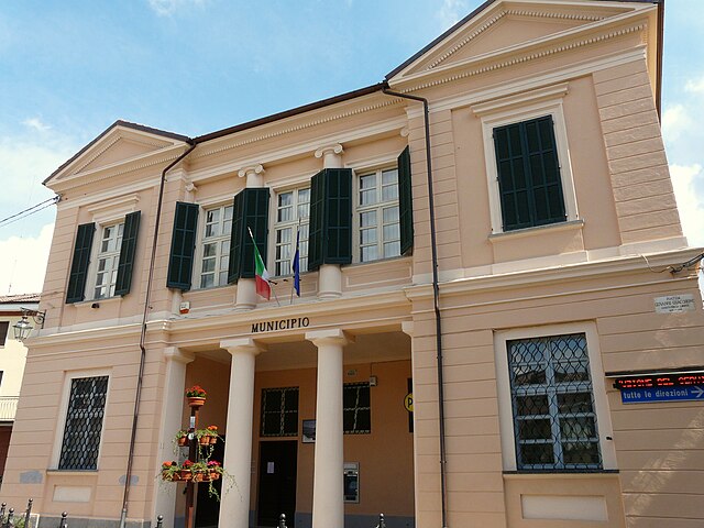
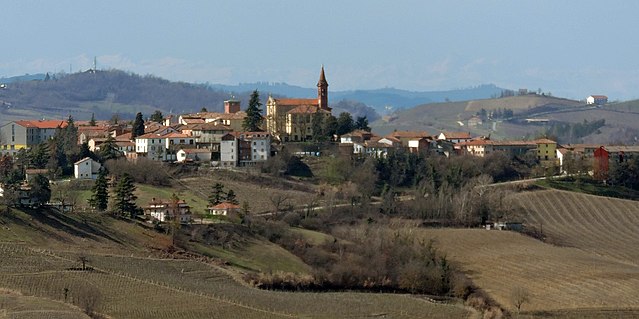
Castelletto Molina (Castelletto Molina)

- Italian comune
 Hiking in Castelletto Molina
Castelletto Molina, a small village in the Piedmont region of Italy, is surrounded by stunning natural landscapes that offer a variety of hiking opportunities. Nestled in the Monferrato hills, this area features rolling hills, vineyards, and scenic views, making it a delightful spot for outdoor enthusiasts.
Hiking Trails
-
Sentiero dei Fiori (Flower Trail): This scenic trail takes you through lush vegetation and showcases local flora. It's a moderate hike, ideal for families and casual hikers.
-
Panoramic Trails: Several paths offer breathtaking views of the Monferrato area and the surrounding vineyards. These trails vary in difficulty and length, making them suitable for different skill levels.
-
Historical Routes: Some trails connect to historical landmarks, allowing hikers to explore ancient villages, churches, and castles while enjoying the natural beauty.
Best Time to Hike
The best seasons for hiking in Castelletto Molina are spring and autumn. During these times, the weather is mild, and the landscapes are particularly beautiful with blooming flowers in spring and colorful foliage in autumn.
Essential Tips
- Proper Footwear: Wear sturdy hiking boots as some trails may be uneven or rocky.
- Weather Check: Always check the weather forecast before heading out, as conditions can change quickly in hilly areas.
- Stay Hydrated: Bring sufficient water, especially during warmer months.
- Local Guidelines: Respect local regulations, stay on marked trails, and be mindful of wildlife.
Additional Activities
Aside from hiking, Castelletto Molina is also known for its excellent wine production, so consider visiting local wineries or engaging in wine tasting tours after your hike.
Overall, Castelletto Molina offers a fantastic blend of nature, culture, and adventure, making it a charming destination for hikers of all levels. Enjoy your time exploring this picturesque corner of Italy!
- Country:

- Postal Code: 14040
- Local Dialing Code: 0141
- Licence Plate Code: AT
- Coordinates: 44° 45' 8" N, 8° 26' 3" E


- GPS tracks (wikiloc): [Link]
- AboveSeaLevel: 227 м m
- Area: 3.07 sq km
- Population: 162
- Web site: http://www.comune.castellettomolina.at.it
- Wikipedia en: wiki(en)
- Wikipedia: wiki(it)
- Wikidata storage: Wikidata: Q17780
- Wikipedia Commons Gallery: [Link]
- Wikipedia Commons Category: [Link]
- Freebase ID: [/m/0gbg75]
- GeoNames ID: Alt: [6542386]
- OSM relation ID: [43548]
- ISTAT ID: 005027
- Italian cadastre code: C161
Shares border with regions:

Alice Bel Colle
- Italian comune
Hiking in Alice Bel Colle
Alice Bel Colle, located in the Piedmont region of Italy, is a charming destination for hiking enthusiasts. It's situated near the town of the same name and is surrounded by beautiful landscapes characterized by rolling hills, vineyards, and lush woodlands. Here’s what you can expect when hiking in this area:...
- Country:
- Postal Code: 15010
- Local Dialing Code: 0144
- Licence Plate Code: AL
- Coordinates: 44° 43' 37" N, 8° 27' 6" E
- GPS tracks (wikiloc): [Link]
- AboveSeaLevel: 418 м m
- Area: 12.21 sq km
- Population: 754
- Web site: [Link]

Castel Rocchero
- Italian comune
Hiking in Castel Rocchero
Castel Rocchero is a beautiful area located in the Piedmont region of Italy, known for its stunning landscapes, rolling hills, and vineyards. Hiking in Castel Rocchero is a fantastic way to explore the natural beauty of this region. Here are some key points to consider when planning your hike:...
- Country:
- Postal Code: 14040
- Local Dialing Code: 0141
- Licence Plate Code: AT
- Coordinates: 44° 43' 9" N, 8° 24' 59" E
- GPS tracks (wikiloc): [Link]
- AboveSeaLevel: 414 м m
- Area: 5.63 sq km
- Population: 396
- Web site: [Link]


Fontanile
- Italian comune
Hiking in Fontanile
Fontanile is a small area located in Italy, often characterized by its picturesque landscapes and natural beauty. While specific hiking trails may not be extensively documented, the surrounding regions, like the hills and countryside of Italy, offer fantastic opportunities for hikers....
- Country:
- Postal Code: 14044
- Local Dialing Code: 0141
- Licence Plate Code: AT
- Coordinates: 44° 45' 11" N, 8° 25' 17" E
- GPS tracks (wikiloc): [Link]
- AboveSeaLevel: 276 м m
- Area: 8.13 sq km
- Population: 560
- Web site: [Link]


Quaranti
- Italian comune
Hiking in Quaranti
Quaranti, often referred to as Quarantine in some contexts, is not widely recognized as a prominent hiking destination. However, if you may be referring to a specific region or area with hiking opportunities, please provide more context or clarify the location....
- Country:
- Postal Code: 14040
- Local Dialing Code: 0141
- Licence Plate Code: AT
- Coordinates: 44° 45' 7" N, 8° 27' 1" E
- GPS tracks (wikiloc): [Link]
- AboveSeaLevel: 273 м m
- Area: 2.86 sq km
- Population: 173
- Web site: [Link]