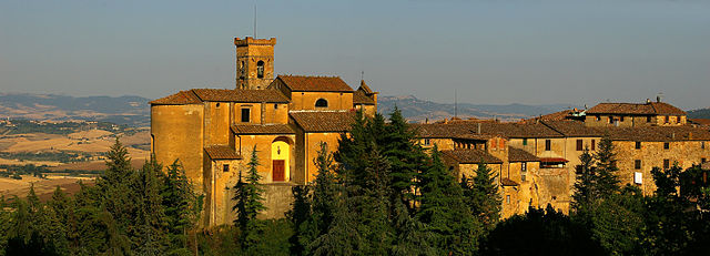
Castellina Marittima (Castellina Marittima)
.svg)
- Italian comune
 Hiking in Castellina Marittima
Castellina Marittima is a beautiful village located in the Tuscany region of Italy, particularly near the Tyrrhenian Sea. Nestled among the hills, this area is known for its stunning landscapes, rich history, and various hiking opportunities. If you're planning to hike in Castellina Marittima, here are some insights to help you make the most of your experience:
Highlights of Hiking in Castellina Marittima
-
Scenic Views: The trails around Castellina Marittima offer breathtaking views of the Tuscan countryside, vineyards, and olive groves, as well as glimpses of the coastline.
-
Diverse Trails: There are various hiking routes available, ranging from easy walks suitable for families to more challenging hikes for experienced trekkers. The terrain often includes forested areas, hills, and agricultural lands.
-
Historical Sites: As you hike, you may encounter historical landmarks, including ancient churches and ruins that tell the story of the region's past.
-
Wildlife: The area is home to diverse wildlife. Keep an eye out for local flora and fauna, including birds, deer, and various plant species.
-
Local Culture: Experience the local culture through small farms, vineyards, and traditional Tuscan cuisine available in nearby villages or at the end of your hike.
Recommended Hiking Trails
-
Trail to the Sea: A popular route leads from Castellina Marittima down to the nearby beaches. This trail typically offers a mix of forest paths and panoramic views.
-
Vineyard Routes: Some trails wind through local vineyards, allowing hikers to experience the rich agricultural heritage of the region.
-
Loop Trails: Several smaller loop trails can be found in the surrounding hills, ideal for short hikes that allow you to enjoy the local scenery without going too far.
Practical Tips
-
Weather: Check the weather before you go. Spring and early autumn are generally the best times to hike in this region due to milder temperatures.
-
Local Maps and Guides: It can be helpful to obtain a local hiking map or guide, as some trails may not be well-signed.
-
Hydration and Supplies: Always carry enough water and snacks, especially if you're planning a longer hike.
-
Footwear: Wear appropriate hiking footwear. Trails can be uneven, so sturdy shoes or boots are recommended.
-
Respect Nature: Follow Leave No Trace principles by staying on marked trails and not disturbing wildlife.
Additional Activities
After a day of hiking, consider exploring the local cuisine in Castellina Marittima. Enjoying traditional Tuscan dishes and wines at local trattorias can be a perfect way to unwind.
Overall, hiking in Castellina Marittima provides a wonderful opportunity to immerse yourself in the natural beauty and cultural richness of Tuscany. Whether you're an experienced hiker or just looking for a leisurely stroll, the area has something to offer for everyone.
- Country:

- Postal Code: 56040
- Local Dialing Code: 050
- Licence Plate Code: PI
- Coordinates: 43° 24' 46" N, 10° 34' 38" E


- GPS tracks (wikiloc): [Link]
- AboveSeaLevel: 375 м m
- Area: 45.52 sq km
- Population: 1961
- Web site: http://www.comunecastellina.it/
- Wikipedia en: wiki(en)
- Wikipedia: wiki(it)
- Wikidata storage: Wikidata: Q103058
- Wikipedia Commons Category: [Link]
- Freebase ID: [/m/0glfdg]
- GeoNames ID: Alt: [6536834]
- VIAF ID: Alt: [130027662]
- OSM relation ID: [42432]
- GND ID: Alt: [10158625-5]
- WOEID: [713361]
- TGN ID: [7006304]
- UN/LOCODE: [ITMTM]
- Digital Atlas of the Roman Empire ID: [38275]
- Pleiades ID: [403194]
- ISTAT ID: 050010
- Italian cadastre code: C174
Shares border with regions:
Chianni
- Italian comune
Hiking in Chianni
Chianni is a picturesque village located in the Tuscany region of Italy, surrounded by beautiful landscapes that are perfect for hiking enthusiasts. Here’s what you should know about hiking in and around Chianni:...
- Country:
- Postal Code: 56034
- Local Dialing Code: 0587
- Licence Plate Code: PI
- Coordinates: 43° 28' 55" N, 10° 38' 34" E
- GPS tracks (wikiloc): [Link]
- AboveSeaLevel: 284 м m
- Area: 61.99 sq km
- Population: 1347
- Web site: [Link]

Riparbella
- Italian comune
Hiking in Riparbella
Riparbella is a charming town in Tuscany, Italy, surrounded by beautiful landscapes that make it an excellent spot for hiking enthusiasts. Here are some highlights for hiking in and around Riparbella:...
- Country:
- Postal Code: 56046
- Local Dialing Code: 0586
- Licence Plate Code: PI
- Coordinates: 43° 22' 0" N, 10° 36' 0" E
- GPS tracks (wikiloc): [Link]
- AboveSeaLevel: 216 м m
- Area: 58.84 sq km
- Population: 1630
- Web site: [Link]

Santa Luce
- Italian comune
Hiking in Santa Luce
Santa Luce, located in the picturesque Tuscany region of Italy, is a wonderful destination for hiking and outdoor activities. The area is characterized by its rolling hills, vineyards, olive groves, and charming villages, making it an ideal spot for nature enthusiasts and hikers....
- Country:
- Postal Code: 56040
- Local Dialing Code: 050
- Licence Plate Code: PI
- Coordinates: 43° 28' 17" N, 10° 33' 46" E
- GPS tracks (wikiloc): [Link]
- AboveSeaLevel: 200 м m
- Area: 66.62 sq km
- Population: 1675
- Web site: [Link]


Cecina
- Italian comune
Hiking in Cecina
Cecina, located in the heart of Tuscany along the Etruscan Coast, offers a variety of hiking experiences that showcase the region's beautiful landscapes, rich history, and vibrant scenery. Here are some key points to consider when hiking in Cecina:...
- Country:
- Postal Code: 57023
- Local Dialing Code: 0586
- Licence Plate Code: LI
- Coordinates: 43° 18' 50" N, 10° 31' 30" E
- GPS tracks (wikiloc): [Link]
- AboveSeaLevel: 15 м m
- Area: 42.52 sq km
- Population: 28112
- Web site: [Link]


Rosignano Marittimo
- Italian comune
Hiking in Rosignano Marittimo
Rosignano Marittimo is a charming town in Tuscany, Italy, known for its picturesque landscapes and proximity to both the Mediterranean Sea and the beautiful rolling hills of the Tuscan countryside. Here are some key points to consider if you’re looking to hike in the area:...
- Country:
- Postal Code: 57016
- Local Dialing Code: 0586
- Licence Plate Code: LI
- Coordinates: 43° 24' 0" N, 10° 28' 0" E
- GPS tracks (wikiloc): [Link]
- AboveSeaLevel: 147 м m
- Area: 120.82 sq km
- Population: 31039
- Web site: [Link]