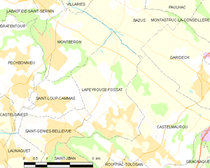
Castelmaurou (Castelmaurou)


- commune in Haute-Garonne, France
- Country:

- Postal Code: 31180
- Coordinates: 43° 40' 36" N, 1° 31' 53" E


- GPS tracks (wikiloc): [Link]
- AboveSeaLevel: 223 м m
- Area: 16.77 sq km
- Population: 4168
- Web site: http://www.mairie-castelmaurou.fr
- Wikipedia en: wiki(en)
- Wikipedia: wiki(fr)
- Wikidata storage: Wikidata: Q629912
- Wikipedia Commons Category: [Link]
- Freebase ID: [/m/03nq365]
- Freebase ID: [/m/03nq365]
- GeoNames ID: Alt: [6615509]
- GeoNames ID: Alt: [6615509]
- SIREN number: [213101173]
- SIREN number: [213101173]
- BnF ID: [152551132]
- BnF ID: [152551132]
- INSEE municipality code: 31117
- INSEE municipality code: 31117
Shares border with regions:


Saint-Jean
- commune in Haute-Garonne, France
- Country:
- Postal Code: 31240
- Coordinates: 43° 39' 55" N, 1° 30' 18" E
- GPS tracks (wikiloc): [Link]
- Area: 5.94 sq km
- Population: 10596
- Web site: [Link]


Saint-Geniès-Bellevue
- commune in Haute-Garonne, France
- Country:
- Postal Code: 31180
- Coordinates: 43° 40' 59" N, 1° 29' 9" E
- GPS tracks (wikiloc): [Link]
- Area: 3.78 sq km
- Population: 2342
- Web site: [Link]

Rouffiac-Tolosan
- commune in Haute-Garonne, France
- Country:
- Postal Code: 31180
- Coordinates: 43° 39' 51" N, 1° 31' 29" E
- GPS tracks (wikiloc): [Link]
- Area: 4.67 sq km
- Population: 2013

Lapeyrouse-Fossat
- commune in Haute-Garonne, France
- Country:
- Postal Code: 31180
- Coordinates: 43° 41' 31" N, 1° 30' 59" E
- GPS tracks (wikiloc): [Link]
- Area: 9.49 sq km
- Population: 2753
- Web site: [Link]


Gragnague
- commune in Haute-Garonne, France
- Country:
- Postal Code: 31380
- Coordinates: 43° 40' 57" N, 1° 34' 59" E
- GPS tracks (wikiloc): [Link]
- Area: 13.04 sq km
- Population: 1746
- Web site: [Link]


Garidech
- commune in Haute-Garonne, France
- Country:
- Postal Code: 31380
- Coordinates: 43° 42' 29" N, 1° 33' 39" E
- GPS tracks (wikiloc): [Link]
- AboveSeaLevel: 173.0 м m
- Area: 7.11 sq km
- Population: 1741
- Web site: [Link]


Bazus
- commune in Haute-Garonne, France
- Country:
- Postal Code: 31380
- Coordinates: 43° 44' 8" N, 1° 31' 3" E
- GPS tracks (wikiloc): [Link]
- Area: 9.13 sq km
- Population: 564
- Web site: [Link]

Beaupuy
- commune in Haute-Garonne, France
- Country:
- Postal Code: 31850
- Coordinates: 43° 38' 50" N, 1° 33' 16" E
- GPS tracks (wikiloc): [Link]
- Area: 5.84 sq km
- Population: 1308
- Web site: [Link]