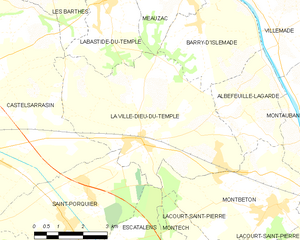
Castelsarrasin (Castelsarrasin)
- commune in Tarn-et-Garonne, France
- Country:

- Postal Code: 82100
- Coordinates: 44° 2' 24" N, 1° 6' 25" E


- GPS tracks (wikiloc): [Link]
- Area: 76.77 sq km
- Population: 13886
- Web site: http://www.ville-castelsarrasin.fr
- Wikipedia en: wiki(en)
- Wikipedia: wiki(fr)
- Wikidata storage: Wikidata: Q213285
- Wikipedia Commons Category: [Link]
- Freebase ID: [/m/06llds]
- Freebase ID: [/m/06llds]
- Freebase ID: [/m/06llds]
- GeoNames ID: Alt: [3028322]
- GeoNames ID: Alt: [3028322]
- GeoNames ID: Alt: [3028322]
- SIREN number: [218200335]
- SIREN number: [218200335]
- SIREN number: [218200335]
- BnF ID: [15277665k]
- BnF ID: [15277665k]
- BnF ID: [15277665k]
- VIAF ID: Alt: [140714856]
- VIAF ID: Alt: [140714856]
- VIAF ID: Alt: [140714856]
- GND ID: Alt: [4256832-8]
- GND ID: Alt: [4256832-8]
- GND ID: Alt: [4256832-8]
- Library of Congress authority ID: Alt: [n80036977]
- Library of Congress authority ID: Alt: [n80036977]
- Library of Congress authority ID: Alt: [n80036977]
- MusicBrainz area ID: [6ab96ff4-ff39-4f4b-85a5-bb29473efcdb]
- MusicBrainz area ID: [6ab96ff4-ff39-4f4b-85a5-bb29473efcdb]
- MusicBrainz area ID: [6ab96ff4-ff39-4f4b-85a5-bb29473efcdb]
- WOEID: [583290]
- WOEID: [583290]
- WOEID: [583290]
- INSEE municipality code: 82033
- INSEE municipality code: 82033
- INSEE municipality code: 82033
Shares border with regions:
Les Barthes
- commune in Tarn-et-Garonne, France
- Country:

- Postal Code: 82100
- Coordinates: 44° 5' 48" N, 1° 10' 12" E


- GPS tracks (wikiloc): [Link]
- Area: 8.2 sq km
- Population: 553


Castelmayran
- commune in Tarn-et-Garonne, France
- Country:

- Postal Code: 82210
- Coordinates: 44° 1' 43" N, 1° 2' 20" E


- GPS tracks (wikiloc): [Link]
- Area: 15.96 sq km
- Population: 1189


Saint-Porquier
- commune in Tarn-et-Garonne, France
- Country:

- Postal Code: 82700
- Coordinates: 44° 0' 17" N, 1° 10' 38" E


- GPS tracks (wikiloc): [Link]
- Area: 15.7 sq km
- Population: 1410


Saint-Aignan
- commune in Tarn-et-Garonne, France
- Country:

- Postal Code: 82100
- Coordinates: 44° 1' 5" N, 1° 4' 28" E


- GPS tracks (wikiloc): [Link]
- Area: 4.85 sq km
- Population: 414


La Ville-Dieu-du-Temple
- commune in Tarn-et-Garonne, France
- Country:

- Postal Code: 82290
- Coordinates: 44° 2' 5" N, 1° 13' 1" E


- GPS tracks (wikiloc): [Link]
- Area: 26.16 sq km
- Population: 3187
- Web site: [Link]


Moissac
- commune in Tarn-et-Garonne, France
- Country:

- Postal Code: 82200
- Coordinates: 44° 6' 17" N, 1° 5' 7" E


- GPS tracks (wikiloc): [Link]
- Area: 85.95 sq km
- Population: 12581
- Web site: [Link]


Saint-Nicolas-de-la-Grave
- commune in Tarn-et-Garonne, France
- Country:

- Postal Code: 82210
- Coordinates: 44° 3' 49" N, 1° 1' 22" E


- GPS tracks (wikiloc): [Link]
- Area: 29.34 sq km
- Population: 2217
- Web site: [Link]


Labastide-du-Temple
- commune in Tarn-et-Garonne, France
- Country:

- Postal Code: 82100
- Coordinates: 44° 5' 5" N, 1° 11' 42" E


- GPS tracks (wikiloc): [Link]
- Area: 10.92 sq km
- Population: 1159
- Web site: [Link]


Castelferrus
- commune in Tarn-et-Garonne, France
- Country:

- Postal Code: 82100
- Coordinates: 44° 0' 34" N, 1° 5' 15" E


- GPS tracks (wikiloc): [Link]
- AboveSeaLevel: 83 м m
- Area: 8.39 sq km
- Population: 452


Cordes-Tolosannes
- commune in Tarn-et-Garonne, France
- Country:

- Postal Code: 82700
- Coordinates: 43° 59' 9" N, 1° 8' 55" E


- GPS tracks (wikiloc): [Link]
- Area: 15.77 sq km
- Population: 354
