Caudrot (Caudrot)

- commune in Gironde, France
- Country:

- Postal Code: 33490
- Coordinates: 44° 34' 36" N, 0° 8' 37" E


- GPS tracks (wikiloc): [Link]
- Area: 6.12 sq km
- Population: 1194
- Web site: http://www.caudrot.fr
- Wikipedia en: wiki(en)
- Wikipedia: wiki(fr)
- Wikidata storage: Wikidata: Q861943
- Wikipedia Commons Category: [Link]
- Freebase ID: [/m/03nry5q]
- GeoNames ID: Alt: [6432180]
- SIREN number: [213301112]
- BnF ID: [15256163v]
- BabelNet ID: [00800928n]
- INSEE municipality code: 33111
Shares border with regions:

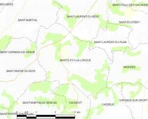
Sainte-Foy-la-Longue
- commune in Gironde, France
- Country:
- Postal Code: 33490
- Coordinates: 44° 36' 35" N, 0° 8' 44" E
- GPS tracks (wikiloc): [Link]
- Area: 9.37 sq km
- Population: 120


Saint-Martin-de-Sescas
- commune in Gironde, France
- Country:
- Postal Code: 33490
- Coordinates: 44° 34' 30" N, 0° 9' 45" E
- GPS tracks (wikiloc): [Link]
- Area: 8.19 sq km
- Population: 618

Castets-en-Dorthe
- former French commune of the department of Gironde, France
- Country:
- Postal Code: 33210
- Coordinates: 44° 33' 42" N, 0° 9' 11" E
- GPS tracks (wikiloc): [Link]
- Area: 8.69 sq km
- Population: 1164
- Web site: [Link]


Casseuil
- commune in Gironde, France
- Country:
- Postal Code: 33190
- Coordinates: 44° 35' 7" N, 0° 6' 52" E
- GPS tracks (wikiloc): [Link]
- Area: 6.34 sq km
- Population: 399


Barie
- commune in Gironde, France
- Country:
- Postal Code: 33190
- Coordinates: 44° 34' 12" N, 0° 6' 53" E
- GPS tracks (wikiloc): [Link]
- Area: 5.33 sq km
- Population: 296
- Web site: [Link]