Ceresole Reale (Ceresole Reale)

- Italian comune
 Hiking in Ceresole Reale
Ceresole Reale is a stunning area located in the Italian Piedmont region, within the Gran Paradiso National Park. It's a fantastic destination for hiking enthusiasts, offering a combination of breathtaking landscapes, diverse flora and fauna, and a variety of trails suitable for different skill levels.
Key Features of Hiking in Ceresole Reale:
-
Scenic Trails: Ceresole Reale boasts numerous hiking trails that cater to varying degrees of difficulty, from easy walks suitable for families to more challenging treks for experienced hikers.
-
Gran Paradiso National Park: This park is the first national park established in Italy and is home to the iconic Gran Paradiso mountain. Hiking here provides stunning views of rugged peaks, valleys, and glacial lakes. Trails here allow you to experience the natural beauty of unspoiled landscapes and alpine ecosystems.
-
Lakes: Near Ceresole Reale are beautiful lakes like Lago di Ceresole, which is a great spot for hiking around and offers opportunities for fishing and relaxing by the water.
-
Flora and Fauna: The area is rich in biodiversity, and hikers may encounter a variety of wildlife, including ibex, chamois, and various bird species. The diverse ecosystems also present a variety of plant life, including unique alpine flowers.
-
Access and Facilities: Ceresole Reale is accessible by road, and there are facilities such as mountain huts (rifugi) along many trails, where hikers can rest or enjoy local cuisine.
-
Guided Tours: For those who prefer a structured experience, guided hikes are available. Local guides can provide insights into the area’s natural history, geology, and cultural heritage.
Popular Hiking Routes:
-
Sentiero degli Alpeggi: A moderate trail offering spectacular views and the opportunity to see traditional alpine pastures.
-
Laghi di Ceresole: This is an easier hike that takes you around the lovely lakes, perfect for a leisurely day out.
-
Refuge Brianza: A more challenging hike that rewards you with stunning panoramic views and an opportunity to experience high-altitude environments.
Tips for Hiking in Ceresole Reale:
-
Weather Prep: The weather can change rapidly in the mountains, so check the forecast before your hike and dress in layers.
-
Familiarize Yourself with the Trails: Study maps and trail signs beforehand. Some trails may have varying levels of difficulty, so choose according to your fitness and experience.
-
Stay Hydrated and Bring Snacks: Always carry enough water and snacks, especially if you are embarking on longer hikes.
-
Respect Nature: Practice Leave No Trace principles by staying on marked trails and packing out everything you bring in.
Whether you're looking for a leisurely hike or an adventurous trek, Ceresole Reale offers something for everyone to enjoy!
- Country:

- Postal Code: 10080
- Local Dialing Code: 0124
- Licence Plate Code: TO
- Coordinates: 45° 26' 0" N, 7° 14' 0" E


- GPS tracks (wikiloc): [Link]
- AboveSeaLevel: 1620 м m
- Area: 99.82 sq km
- Population: 164
- Web site: http://www.comune.ceresolereale.to.it
- Wikipedia en: wiki(en)
- Wikipedia: wiki(it)
- Wikidata storage: Wikidata: Q9245
- Wikipedia Commons Gallery: [Link]
- Wikipedia Commons Category: [Link]
- Freebase ID: [/m/0g6vbf]
- GeoNames ID: Alt: [6540661]
- VIAF ID: Alt: [316388626]
- OSM relation ID: [44958]
- TGN ID: [1044157]
- ISTAT ID: 001073
- Italian cadastre code: C505
Shares border with regions:


Val-d'Isère
- commune in Savoie, France
Hiking in Val-d'Isère
Val-d'Isère, located in the French Alps, is a renowned ski resort that also offers spectacular hiking opportunities during the summer months. The area is known for its breathtaking mountain scenery, alpine meadows, and a variety of hiking trails suitable for different skill levels. Here are some highlights to consider if you plan to hike in Val-d'Isère:...
- Country:

- Postal Code: 73150
- Coordinates: 45° 26' 59" N, 6° 58' 38" E
- GPS tracks (wikiloc): [Link]
- AboveSeaLevel: 1850 м m
- Area: 94.39 sq km
- Population: 1583
- Web site: [Link]


Rhêmes-Notre-Dame
- Italian comune
Hiking in Rhêmes-Notre-Dame
Rhêmes-Notre-Dame is a charming village located in the Aosta Valley of Italy, nestled in the heart of the Gran Paradiso National Park. This picturesque area is known for its stunning landscapes, diverse wildlife, and an extensive network of hiking trails that cater to all levels of experience....
- Country:
- Postal Code: 11010
- Local Dialing Code: 0165
- Licence Plate Code: AO
- Coordinates: 45° 34' 11" N, 7° 7' 7" E
- GPS tracks (wikiloc): [Link]
- AboveSeaLevel: 1725 м m
- Area: 86.84 sq km
- Population: 82
- Web site: [Link]

Valsavarenche
- Italian comune
Hiking in Valsavarenche
Valsavarenche is a picturesque valley located in the Aosta Valley region of the Italian Alps, and it is part of the Gran Paradiso National Park. This area is known for its stunning natural beauty, diverse wildlife, and well-maintained trails, making it an excellent destination for hiking enthusiasts....
- Country:
- Postal Code: 11010
- Local Dialing Code: 0165
- Licence Plate Code: AO
- Coordinates: 45° 35' 32" N, 7° 12' 28" E
- GPS tracks (wikiloc): [Link]
- AboveSeaLevel: 1541 м m
- Area: 138.21 sq km
- Population: 164
- Web site: [Link]
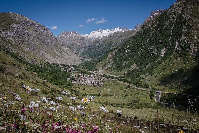
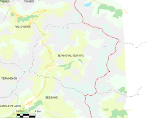
Bonneval-sur-Arc
- commune in Savoie, France
Hiking in Bonneval-sur-Arc
Bonneval-sur-Arc is a stunning location for hiking, situated in the French Alps within the Vanoise National Park. Known for its picturesque landscapes, high peaks, and well-preserved alpine environment, it offers a range of trails suitable for different levels of hikers....
- Country:
- Postal Code: 73480
- Coordinates: 45° 22' 16" N, 7° 2' 47" E
- GPS tracks (wikiloc): [Link]
- Area: 82.72 sq km
- Population: 255
- Web site: [Link]


Groscavallo
- Italian comune
Hiking in Groscavallo
Groscavallo is a beautiful area located in the Piedmont region of Italy, nestled in the Alps. Known for its stunning landscapes and natural beauty, it offers a variety of hiking opportunities for both beginners and experienced hikers....
- Country:
- Postal Code: 10070
- Local Dialing Code: 0123
- Licence Plate Code: TO
- Coordinates: 45° 22' 0" N, 7° 16' 0" E
- GPS tracks (wikiloc): [Link]
- AboveSeaLevel: 1110 м m
- Area: 92.09 sq km
- Population: 204
- Web site: [Link]
Noasca
- Italian comune
Hiking in Noasca
Noasca is a picturesque village located in the Aosta Valley region of Italy, nestled in the heart of the Gran Paradiso National Park. It's a great destination for hikers of all experience levels, offering stunning landscapes, varied trails, and a rich natural environment....
- Country:
- Postal Code: 10080
- Local Dialing Code: 0124
- Licence Plate Code: TO
- Coordinates: 45° 27' 0" N, 7° 19' 0" E
- GPS tracks (wikiloc): [Link]
- AboveSeaLevel: 1065 м m
- Area: 78.05 sq km
- Population: 120
- Web site: [Link]