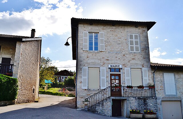
Ceyzériat (Ceyzériat)
- commune in Ain, France
 Hiking in Ceyzériat
Ceyzériat is a small commune located in the Ain department of the Auvergne-Rhône-Alpes region in eastern France. While it may not be a well-known hiking destination compared to national parks or famous mountain ranges, there are opportunities for enjoying nature walks and exploring the surrounding area.
Hiking Opportunities
-
Local Trails: Ceyzériat and its surroundings offer a variety of local hiking trails that range from easy walks to more challenging routes. These trails can take you through scenic rural landscapes, forests, and along rivers.
-
Nearby Natural Areas: Explore the nearby Dombes region, which consists of numerous lakes and wetlands. The area is known for its rich biodiversity, making it a great spot for both hiking and birdwatching.
-
Regional Parks: The Parc naturel régional du Haut-Jura is not too far from Ceyzériat. This regional park offers extensive hiking opportunities with clearly marked trails that allow hikers to experience the diverse flora and fauna of the Jura mountain range.
Tips for Hiking in Ceyzériat
-
Check the Weather: Always check the local weather before heading out, as conditions can change rapidly, especially in the cooler months.
-
Trail Maps: Bring a trail map or download a hiking app to help navigate the routes. This can be especially useful if you're exploring unfamiliar trails.
-
Footwear: Wear sturdy hiking shoes or boots to provide support for your feet, particularly if you plan on tackling rocky or uneven terrain.
-
Hydration and Snacks: Carry enough water and some snacks, especially if you plan on hiking for several hours.
-
Respect Nature: Follow the Leave No Trace principles to minimize your impact on the environment and preserve the natural beauty for future hikers.
Conclusion
While Ceyzériat may not have the most extensive hiking ecosystem, it offers a peaceful setting where you can enjoy nature. If you seek more extensive hiking adventures, consider exploring nearby regions or national parks for varied terrain and scenic vistas. Always prioritize safety and enjoy immersing yourself in the beauty of the outdoors!
- Country:

- Postal Code: 01250
- Coordinates: 46° 10' 42" N, 5° 19' 26" E


- GPS tracks (wikiloc): [Link]
- Area: 9.36 sq km
- Population: 3118
- Web site: http://www.ceyzeriat.com
- Wikipedia en: wiki(en)
- Wikipedia: wiki(fr)
- Wikidata storage: Wikidata: Q210104
- Wikipedia Commons Category: [Link]
- Wikipedia Commons Maps Category: [Link]
- Freebase ID: [/m/08142v]
- Freebase ID: [/m/08142v]
- GeoNames ID: Alt: [3027740]
- GeoNames ID: Alt: [3027740]
- SIREN number: [210100723]
- SIREN number: [210100723]
- BnF ID: [123017484]
- BnF ID: [123017484]
- VIAF ID: Alt: [237427874]
- VIAF ID: Alt: [237427874]
- WOEID: [583754]
- WOEID: [583754]
- INSEE municipality code: 01072
- INSEE municipality code: 01072
Shares border with regions:

Jasseron
- commune in Ain, France
Hiking in Jasseron
Jasseron, located in the Ain department of the Auvergne-Rhône-Alpes region in eastern France, offers beautiful landscapes for hiking enthusiasts. The area is characterized by rolling hills, lush greenery, and scenic views, making it an excellent destination for hikers of all levels....
- Country:
- Postal Code: 01250
- Coordinates: 46° 12' 45" N, 5° 19' 28" E
- GPS tracks (wikiloc): [Link]
- Area: 18.93 sq km
- Population: 1735
- Web site: [Link]

Montagnat
- commune in Ain, France
Hiking in Montagnat
Montagnat is a commune located in the Ain department in the Auvergne-Rhône-Alpes region of France. While Montagnat itself may not be widely recognized as a major hiking destination, it offers access to the beautiful surrounding landscapes and trails in the region....
- Country:
- Postal Code: 01250
- Coordinates: 46° 10' 15" N, 5° 17' 3" E
- GPS tracks (wikiloc): [Link]
- Area: 13.75 sq km
- Population: 1921
- Web site: [Link]

Revonnas
- commune in Ain, France
Hiking in Revonnas
Revonnas, located in the Auvergne-Rhône-Alpes region of France, offers beautiful hiking opportunities for outdoor enthusiasts. It’s known for its picturesque landscapes, diverse flora and fauna, and proximity to the Bugey mountains....
- Country:
- Postal Code: 01250
- Coordinates: 46° 9' 44" N, 5° 19' 49" E
- GPS tracks (wikiloc): [Link]
- Area: 7.75 sq km
- Population: 938
- Web site: [Link]
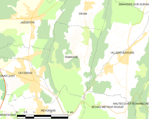
Ramasse
- commune in Ain, France
Hiking in Ramasse
Ramasse is located in the Auvergne region of France, in the department of Puy-de-Dôme. This area offers beautiful landscapes and a variety of hiking trails that cater to different skill levels. The surrounding volcanic terrain, rolling hills, and lush greenery make it an appealing destination for outdoor enthusiasts....
- Country:
- Postal Code: 01250
- Coordinates: 46° 11' 42" N, 5° 21' 19" E
- GPS tracks (wikiloc): [Link]
- Area: 9.86 sq km
- Population: 312
- Web site: [Link]

Saint-Just
- commune in Ain, France
Hiking in Saint-Just
Saint-Just, located in the Ain department of France, is a charming village not far from the larger town of Bourg-en-Bresse. This area offers a variety of hiking opportunities, thanks to its picturesque landscapes, rolling hills, and proximity to the natural beauty of the surrounding region....
- Country:
- Postal Code: 01250
- Coordinates: 46° 11' 25" N, 5° 16' 48" E
- GPS tracks (wikiloc): [Link]
- Area: 3.38 sq km
- Population: 907
- Web site: [Link]