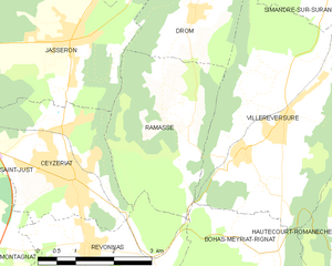
Ramasse (Ramasse)
- commune in Ain, France
Ramasse is located in the Auvergne region of France, in the department of Puy-de-Dôme. This area offers beautiful landscapes and a variety of hiking trails that cater to different skill levels. The surrounding volcanic terrain, rolling hills, and lush greenery make it an appealing destination for outdoor enthusiasts.
Hiking Highlights in Ramasse:
-
Trail Variety: There are multiple trails ranging from easy walks suited for families to more challenging hikes for experienced hikers. The trails often lead through scenic natural parks and offer views of the lush countryside.
-
Volcanic Landscape: The Auvergne region is known for its volcanic features, including dormant volcanoes and craters. Hiking in this area provides unique geological insights as well as stunning panoramic views.
-
Flora and Fauna: The hikes around Ramasse can give you the opportunity to encounter diverse plant species and wildlife, particularly in the protected areas. Be on the lookout for local bird species and unique plant life.
-
Local Culture: In addition to nature, hiking in Ramasse allows you to experience the local culture. You might find small villages along the trails where you can sample regional cuisine and visit charming local markets.
-
Accessibility: The trailheads are generally accessible by car, making it easy to reach various hiking starting points. However, it's essential to check local conditions and any necessary permissions or guidelines that may be in place.
-
Safety Tips:
- Always check the weather forecast before heading out.
- Bring plenty of water and snacks.
- Wear appropriate footwear and clothing for hiking.
- Consider informing someone about your hiking plans, particularly if you are hiking in more remote areas.
Make sure to check local hiking guides or maps for detailed trail information and seek advice from local hiking groups or tourist information centers for the best hiking experiences in Ramasse. Happy hiking!
- Country:

- Postal Code: 01250
- Coordinates: 46° 11' 42" N, 5° 21' 19" E


- GPS tracks (wikiloc): [Link]
- Area: 9.86 sq km
- Population: 312
- Web site: https://ramasse.fr
- Wikipedia en: wiki(en)
- Wikipedia: wiki(fr)
- Wikidata storage: Wikidata: Q777019
- Wikipedia Commons Category: [Link]
- Wikipedia Commons Maps Category: [Link]
- Freebase ID: [/m/081n7b]
- Freebase ID: [/m/081n7b]
- Freebase ID: [/m/081n7b]
- GeoNames ID: Alt: [6424639]
- GeoNames ID: Alt: [6424639]
- GeoNames ID: Alt: [6424639]
- SIREN number: [210103172]
- SIREN number: [210103172]
- SIREN number: [210103172]
- INSEE municipality code: 01317
- INSEE municipality code: 01317
- INSEE municipality code: 01317
Shares border with regions:

Bohas-Meyriat-Rignat
- commune in Ain, France
 Hiking in Bohas-Meyriat-Rignat
Bohas-Meyriat-Rignat is a scenic area located in France, particularly suitable for hikers looking for a mix of natural beauty and tranquility. Nestled in the Jura region, this area features diverse landscapes including rolling hills, forests, and picturesque countryside....
- Country:

- Postal Code: 01250
- Coordinates: 46° 8' 13" N, 5° 23' 28" E


- GPS tracks (wikiloc): [Link]
- Area: 23.51 sq km
- Population: 878
- Web site: [Link]

Ceyzériat
- commune in Ain, France
Ceyzériat is a small commune located in the Ain department of the Auvergne-Rhône-Alpes region in eastern France. While it may not be a well-known hiking destination compared to national parks or famous mountain ranges, there are opportunities for enjoying nature walks and exploring the surrounding area....
- Country:

- Postal Code: 01250
- Coordinates: 46° 10' 42" N, 5° 19' 26" E


- GPS tracks (wikiloc): [Link]
- Area: 9.36 sq km
- Population: 3118
- Web site: [Link]

Jasseron
- commune in Ain, France
Jasseron, located in the Ain department of the Auvergne-Rhône-Alpes region in eastern France, offers beautiful landscapes for hiking enthusiasts. The area is characterized by rolling hills, lush greenery, and scenic views, making it an excellent destination for hikers of all levels....
- Country:

- Postal Code: 01250
- Coordinates: 46° 12' 45" N, 5° 19' 28" E


- GPS tracks (wikiloc): [Link]
- Area: 18.93 sq km
- Population: 1735
- Web site: [Link]

Revonnas
- commune in Ain, France
Revonnas, located in the Auvergne-Rhône-Alpes region of France, offers beautiful hiking opportunities for outdoor enthusiasts. It’s known for its picturesque landscapes, diverse flora and fauna, and proximity to the Bugey mountains....
- Country:

- Postal Code: 01250
- Coordinates: 46° 9' 44" N, 5° 19' 49" E


- GPS tracks (wikiloc): [Link]
- Area: 7.75 sq km
- Population: 938
- Web site: [Link]

Villereversure
- commune in Ain, France
Villereversure is a small commune in the Jura department of France, located in a picturesque area characterized by rolling hills, forests, and panoramic views of the surrounding landscapes. Hiking in this region offers a great escape into nature, with options ranging from easy walks to more challenging trails....
- Country:

- Postal Code: 01250
- Coordinates: 46° 11' 31" N, 5° 23' 46" E


- GPS tracks (wikiloc): [Link]
- Area: 17.45 sq km
- Population: 1262
- Web site: [Link]

Drom
- commune in Ain, France
Drom is a location in Ireland, known for its scenic beauty and diverse hiking opportunities. While it may not be as widely recognized as some of the more famous trails in the country, Drom and its surroundings offer a variety of hiking experiences suitable for different skill levels. Here are some highlights for hiking in the Drom area:...
- Country:

- Postal Code: 01250
- Coordinates: 46° 13' 3" N, 5° 22' 7" E


- GPS tracks (wikiloc): [Link]
- Area: 7.78 sq km
- Population: 219
- Web site: [Link]
