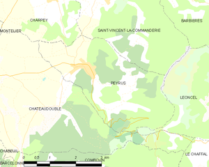
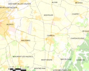
Châteaudouble (Châteaudouble)

- commune in Drôme, France
 Hiking in Châteaudouble
Châteaudouble, located in the Drôme department of southeastern France, is an excellent destination for hiking enthusiasts. This charming village is nestled amidst stunning natural scenery, characterized by picturesque hills and sweeping valleys.
Hiking Trails
-
Local Trails: The area around Châteaudouble offers various hiking trails that cater to different skill levels. Many trails meander through forests, vineyards, and along the cliffs, providing unique viewpoints of the surrounding landscapes.
-
Via Ferrata: For those seeking a bit of adventure, you can find via ferrata routes nearby. These routes combine hiking with climbing, offering a thrilling experience for more adventurous hikers.
-
The GR Trails: Châteaudouble is also situated near the GR (Grande Randonnée) trails that crisscross the region. These long-distance hiking paths allow for multi-day hikes through the beautiful landscapes of the Drôme Provençale.
Highlights
- Views: Many hiking routes offer spectacular vistas over the Drôme Valley and the distant Alps, making them perfect for photography enthusiasts.
- Flora and Fauna: The region is rich in biodiversity, so keep an eye out for unique plant species and local wildlife during your hikes.
- Historical Sites: Some trails may lead you to ancient ruins or historical landmarks, adding a cultural aspect to your hiking experience.
Practical Information
- Season: Spring and autumn are ideal times to hike in this region, as temperatures are mild and the landscapes are particularly vibrant.
- Equipment: Good hiking boots, plenty of water, and a map or GPS device are essential for a safe and enjoyable experience.
- Local Regulations: Always check for any local guidelines or required permits, especially for more challenging routes or when entering protected areas.
Overall, hiking in Châteaudouble offers a wonderful blend of natural beauty, adventure, and cultural exploration, making it a must-visit for outdoor lovers.
- Country:

- Postal Code: 26120
- Coordinates: 44° 53' 59" N, 5° 5' 43" E


- GPS tracks (wikiloc): [Link]
- Area: 17.37 sq km
- Population: 583
- Wikipedia en: wiki(en)
- Wikipedia: wiki(fr)
- Wikidata storage: Wikidata: Q664270
- Wikipedia Commons Category: [Link]
- Freebase ID: [/m/03mhfq5]
- GeoNames ID: Alt: [6447912]
- SIREN number: [212600811]
- BnF ID: [152529424]
- VIAF ID: Alt: [243200370]
- PACTOLS thesaurus ID: [pcrt91XPgJLDzF]
- INSEE municipality code: 26081
Shares border with regions:

Peyrus
- commune in Drôme, France
Hiking in Peyrus
Peyrus is a charming town located in the Auvergne-Rhône-Alpes region of France, near the foothills of the Vercors Massif. It offers a variety of hiking opportunities that cater to different skill levels, showcasing beautiful landscapes, rich biodiversity, and cultural heritage....
- Country:
- Postal Code: 26120
- Coordinates: 44° 54' 46" N, 5° 6' 30" E
- GPS tracks (wikiloc): [Link]
- Area: 10.48 sq km
- Population: 607

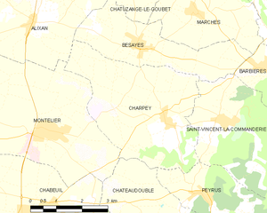
Charpey
- commune in Drôme, France
Hiking in Charpey
Charpey is a small commune in the Drôme department in southeastern France, known for its beautiful natural surroundings and access to hiking trails. While it may not be as widely recognized as some other hiking destinations, it offers a peaceful and picturesque setting for outdoor enthusiasts....
- Country:
- Postal Code: 26300
- Coordinates: 44° 56' 18" N, 5° 5' 34" E
- GPS tracks (wikiloc): [Link]
- Area: 15.48 sq km
- Population: 1316
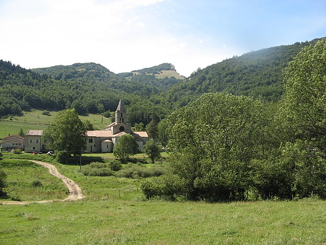

Léoncel
- commune in Drôme, France
Hiking in Léoncel
Léoncel is a beautiful village located in the Drôme department of the Auvergne-Rhône-Alpes region in southeastern France. It is situated in the Vercors Massif, which offers diverse landscapes and rich natural beauty, making it an excellent destination for hiking enthusiasts....
- Country:
- Postal Code: 26190
- Coordinates: 44° 54' 39" N, 5° 11' 34" E
- GPS tracks (wikiloc): [Link]
- Area: 43.01 sq km
- Population: 58


Le Chaffal
- commune in Drôme, France
Hiking in Le Chaffal
Le Chaffal is a picturesque region located in the French Alps, known for its stunning landscapes, diverse terrain, and rich natural beauty. While it may not be as famous as some of the larger national parks or summits in the Alps, it offers a range of hiking opportunities suitable for various skill levels....
- Country:
- Postal Code: 26190
- Coordinates: 44° 53' 13" N, 5° 10' 57" E
- GPS tracks (wikiloc): [Link]
- Area: 11.58 sq km
- Population: 44

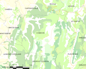
Combovin
- commune in Drôme, France
Hiking in Combovin
Combovin is a charming village located in the Drôme department of the Auvergne-Rhône-Alpes region in southeastern France. It is known for its picturesque landscapes, making it a delightful destination for hiking enthusiasts. Here are some key points about hiking in and around Combovin:...
- Country:
- Postal Code: 26120
- Coordinates: 44° 52' 26" N, 5° 4' 41" E
- GPS tracks (wikiloc): [Link]
- Area: 35.86 sq km
- Population: 405

Chabeuil
- commune in Drôme, France
Hiking in Chabeuil
Chabeuil is a charming commune located in the Drôme department in southeastern France, near the city of Valence. It offers a variety of hiking opportunities, showcasing the stunning landscapes of the Rhône-Alpes region. Here are some highlights about hiking in Chabeuil:...
- Country:
- Postal Code: 26120
- Coordinates: 44° 53' 59" N, 5° 1' 12" E
- GPS tracks (wikiloc): [Link]
- Area: 41.07 sq km
- Population: 6896
- Web site: [Link]


Montélier
- commune in Drôme, France
Hiking in Montélier
Montélier, located in the Drôme department of southeastern France, is a charming village that provides access to beautiful hiking opportunities, particularly within the surrounding regions of the Vercors and the Col de la Machine. Here are some highlights for hiking in and around Montélier:...
- Country:
- Postal Code: 26120
- Coordinates: 44° 56' 15" N, 5° 1' 52" E
- GPS tracks (wikiloc): [Link]
- Area: 24.76 sq km
- Population: 4074