
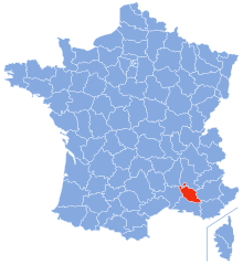
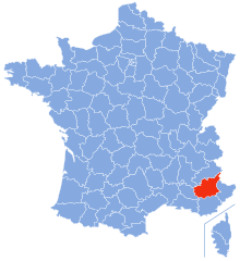
Drôme (Drôme)


- French department
 Hiking in Drôme
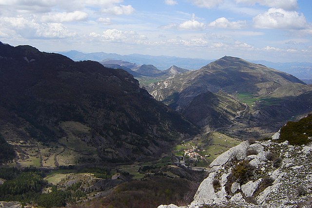
Hiking in the Drôme department in southeastern France is a fantastic experience, known for its diverse landscapes, charming villages, and rich natural heritage. The area offers a variety of trails suitable for all levels of hikers, from beginners to advanced.
Key Highlights of Hiking in Drôme:
-
Scenic Diversity: The Drôme features a range of terrains, including vineyards, lavender fields, rolling hills, and dramatic cliffs. The landscape is part of the Rhône-Alpes region, and it also includes sections of the Vercors Regional Natural Park, providing stunning views and varied terrains.
-
Vercors Massif: This mountain range is particularly popular for hiking. There are numerous trails here, with routes leading through deep gorges, pine forests, and along the cliffs. The famous GR91 (Grande Randonnée) trail runs through the Vercors, offering both challenging and easier segments.
-
Druent Valley: Located near the town of Die, this valley is known for its beautiful hiking paths that meander through the countryside, often with vineyard views and opportunities for spotting local wildlife.
-
Historical Trails: The region is dotted with historical sites, including ancient ruins and picturesque villages like Nyons, Grignan, and Dieulefit. Many hiking trails lead to or pass by these charming locations, making them great stops along your journey.
-
Lavender Routes: In the summer months, the lavender fields in Drôme offer a spectacular sight. There are specific trails that allow you to experience the stunning colors and scents of blooming lavender, particularly around July.
-
Practical Considerations:
- Weather: The best time to hike in Drôme is typically from spring to early autumn. The weather can be quite hot in the summer, so early morning hikes are advisable.
- Preparation: Ensure you have proper gear, including good hiking shoes, plenty of water, and maps or GPS devices, as some trails can be less marked than in more popular hiking areas.
- Local Resources: The local tourism offices can provide maps, recommended trails, and additional information about safety and etiquette in the natural areas.
-
Accessibility: The Drôme is relatively easy to access from major cities like Lyon or Grenoble, making it a great option for a day hike or a longer hiking trip.
Whether you're interested in a peaceful stroll through vineyards or a challenging ascent in the Vercors, Drôme offers something for every hiking enthusiast!
- Country:

- Capital: Valence
- Coordinates: 44° 45' 0" N, 5° 10' 0" E


- GPS tracks (wikiloc): [Link]
- Area: 6530 sq km
- Population: 504637
- Web site: http://www.drome.gouv.fr/
- Wikipedia en: wiki(en)
- Wikipedia: wiki(fr)
- Wikidata storage: Wikidata: Q3364
- Wikipedia Commons Gallery: [Link]
- Wikipedia Commons Category: [Link]
- Wikipedia Commons Maps Category: [Link]
- Freebase ID: [/m/0lgyh]
- GeoNames ID: Alt: [3020781]
- SIREN number: [222600017]
- BnF ID: [11931331t]
- VIAF ID: Alt: [133623905]
- OSM relation ID: [7434]
- GND ID: Alt: [4085493-0]
- archINFORM location ID: [100]
- Library of Congress authority ID: Alt: [n81022472]
- MusicBrainz area ID: [475d8350-a598-4da8-ada4-b4c2dd1d93fe]
- TGN ID: [7002934]
- Encyclopædia Britannica Online ID: [place/Drome]
- Gran Enciclopèdia Catalana ID: [0022997]
- Twitter username: Alt: [La_drome]
- National Library of Israel ID: [000983706]
- NUTS code: [FR713]
- INSEE department code: [26]
- ISO 3166-2 code: FR-26
Includes regions:

arrondissement of Montélimar
- former arrondissement of Drôme, France
- Country:
- Capital: Montélimar

arrondissement of Nyons
- arrondissement of France
Hiking in arrondissement of Nyons
Hiking in the Arrondissement of Nyons, located in the Drôme department in the Auvergne-Rhône-Alpes region of France, offers a variety of scenic trails set amidst beautiful landscapes. This area is known for its Mediterranean climate, picturesque vineyards, and olive groves, as well as its mountainous terrain, making it a fantastic destination for outdoor enthusiasts....
- Country:
- Capital: Nyons
- Coordinates: 44° 20' 0" N, 5° 10' 0" E
- GPS tracks (wikiloc): [Link]
- Area: 1722 sq km
- Population: 146763


arrondissement of Die
- arrondissement of France
Hiking in arrondissement of Die
The Arrondissement of Die, located in the Drôme department of southeastern France, offers beautiful and varied landscapes that are perfect for hiking enthusiasts. Nestled in the Rhône-Alpes region, Die is surrounded by the stunning Vercors and Diois mountains, providing a range of trails suitable for different skill levels and experiences....
- Country:
- Capital: Die
- Coordinates: 44° 40' 0" N, 5° 15' 0" E
- GPS tracks (wikiloc): [Link]
- Area: 2287 sq km
- Population: 66375


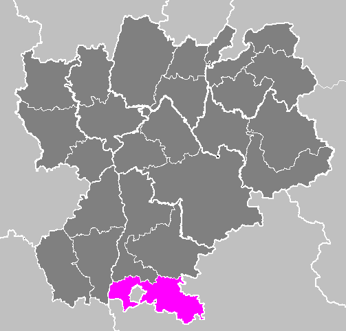
arrondissement of Valence
- arrondissement of France
Hiking in arrondissement of Valence
The Arrondissement of Valence, located in the Drôme department in southeastern France, is known for its stunning landscapes and diverse hiking opportunities. Here are some highlights for hiking in this region:...
- Country:
- Capital: Valence
- Coordinates: 45° 0' 0" N, 5° 0' 0" E
- GPS tracks (wikiloc): [Link]
- Area: 2521 sq km
- Population: 291499
Shares border with regions:


Isère
- French department
Hiking in Isère
Isère, located in the Auvergne-Rhône-Alpes region of France, offers some of the most beautiful and diverse hiking opportunities in the French Alps. Known for its stunning mountain scenery, charming villages, and rich cultural heritage, Isère is a fantastic destination for hikers of all levels. Here are some highlights of hiking in Isère:...
- Country:
- Capital: Grenoble
- Coordinates: 45° 20' 0" N, 5° 30' 0" E
- GPS tracks (wikiloc): [Link]
- AboveSeaLevel: 846 м m
- Area: 7431 sq km
- Population: 1251060
- Web site: [Link]
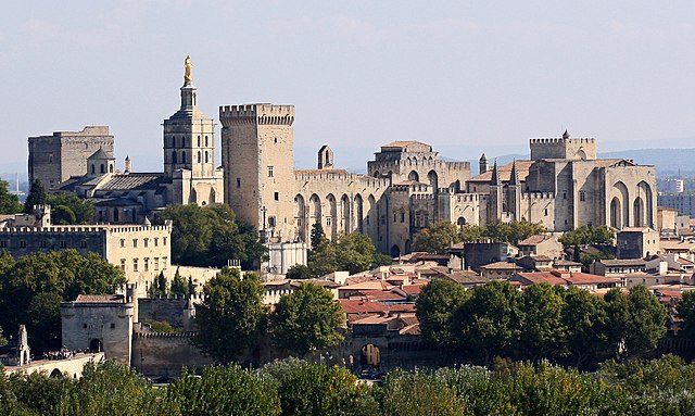
Vaucluse
- French department
Hiking in Vaucluse
Vaucluse, located in the Provence-Alpes-Côte d'Azur region of southeastern France, offers a diverse range of hiking opportunities, combining stunning landscapes, historical sites, and charming villages. Here are some highlights for hiking in Vaucluse:...
- Country:
- Capital: Avignon
- Licence Plate Code: 84
- Coordinates: 44° 0' 0" N, 5° 10' 0" E
- GPS tracks (wikiloc): [Link]
- Area: 3567 sq km
- Population: 557548
- Web site: [Link]

Hautes-Alpes
- department in southeastern France named after the Alps mountain range
Hiking in Hautes-Alpes
The Hautes-Alpes region in southeastern France is a spectacular destination for hiking enthusiasts, known for its stunning landscapes, diverse terrain, and rich biodiversity. The region is part of the French Alps and offers a variety of hiking trails suitable for different skill levels....
- Country:
- Capital: Gap
- Coordinates: 44° 40' 0" N, 6° 20' 0" E
- GPS tracks (wikiloc): [Link]
- AboveSeaLevel: 1665 м m
- Area: 5549 sq km
- Population: 140916
- Web site: [Link]
Alpes-de-Haute-Provence
- French department
Hiking in Alpes-de-Haute-Provence
Hiking in the Alpes-de-Haute-Provence region of southeastern France offers a unique blend of stunning landscapes, diverse ecosystems, and charming villages. Here are some key points to consider if you’re planning a hiking trip in this area:...
- Country:
- Capital: Digne-les-Bains
- Coordinates: 44° 5' 43" N, 6° 14' 24" E
- GPS tracks (wikiloc): [Link]
- Area: 6925 sq km
- Population: 161799
- Web site: [Link]


Ardèche
- French department
Hiking in Ardèche
Hiking in the Ardèche region of France offers a remarkable experience for outdoor enthusiasts, with diverse landscapes ranging from dramatic gorges to tranquil forests. Here are some key aspects to consider when hiking in Ardèche:...
- Country:
- Capital: Privas
- Coordinates: 44° 40' 0" N, 4° 25' 0" E
- GPS tracks (wikiloc): [Link]
- Area: 5529 sq km
- Population: 324209
- Web site: [Link]