Chérancé (Chérancé)

- commune in Mayenne, France
- Country:

- Postal Code: 53400
- Coordinates: 47° 47' 43" N, 0° 56' 8" E


- GPS tracks (wikiloc): [Link]
- AboveSeaLevel: 54 м m
- Area: 8.73 sq km
- Population: 160
- Wikipedia en: wiki(en)
- Wikipedia: wiki(fr)
- Wikidata storage: Wikidata: Q1060394
- Wikipedia Commons Category: [Link]
- Freebase ID: [/m/03qdd27]
- Freebase ID: [/m/03qdd27]
- GeoNames ID: Alt: [6617021]
- GeoNames ID: Alt: [6617021]
- SIREN number: [215300682]
- SIREN number: [215300682]
- INSEE municipality code: 53068
- INSEE municipality code: 53068
Shares border with regions:


Châtelais
- former commune in Maine-et-Loire, France
- Country:
- Postal Code: 49520
- Coordinates: 47° 45' 27" N, 0° 55' 38" E
- GPS tracks (wikiloc): [Link]
- Area: 23.68 sq km
- Population: 664


Mée
- commune in Mayenne, France
- Country:
- Postal Code: 53400
- Coordinates: 47° 47' 50" N, 0° 51' 38" E
- GPS tracks (wikiloc): [Link]
- Area: 8.75 sq km
- Population: 216
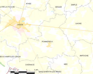
Pommerieux
- commune in Mayenne, France
- Country:
- Postal Code: 53400
- Coordinates: 47° 49' 24" N, 0° 53' 54" E
- GPS tracks (wikiloc): [Link]
- Area: 23.2 sq km
- Population: 671
- Web site: [Link]


Bouchamps-lès-Craon
- commune in Mayenne, France
- Country:
- Postal Code: 53800
- Coordinates: 47° 48' 53" N, 0° 59' 32" E
- GPS tracks (wikiloc): [Link]
- Area: 18.15 sq km
- Population: 556
- Web site: [Link]


Craon
- commune in Mayenne, France
- Country:
- Postal Code: 53400
- Coordinates: 47° 50' 53" N, 0° 56' 59" E
- GPS tracks (wikiloc): [Link]
- Area: 24.56 sq km
- Population: 4509
- Web site: [Link]

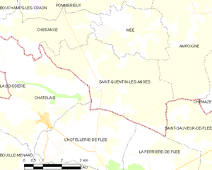
Saint-Quentin-les-Anges
- commune in Mayenne, France
- Country:
- Postal Code: 53400
- Coordinates: 47° 46' 23" N, 0° 53' 10" E
- GPS tracks (wikiloc): [Link]
- Area: 17.81 sq km
- Population: 419
- Web site: [Link]