Chammes (Chammes)
- former commune in Mayenne, France
- Country:

- Postal Code: 53270
- Coordinates: 48° 4' 36" N, 0° 22' 40" E


- GPS tracks (wikiloc): [Link]
- Area: 21.06 sq km
- Population: 349
- Wikipedia en: wiki(en)
- Wikipedia: wiki(fr)
- Wikidata storage: Wikidata: Q743762
- Wikipedia Commons Category: [Link]
- Freebase ID: [/m/03nq0zb]
- GeoNames ID: Alt: [3027305]
- BnF ID: [152638440]
- INSEE municipality code: 53050
Shares border with regions:

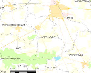
Châtres-la-Forêt
- commune in Mayenne, France
- Country:
- Postal Code: 53600
- Coordinates: 48° 8' 1" N, 0° 25' 54" E
- GPS tracks (wikiloc): [Link]
- Area: 13.6 sq km
- Population: 787
- Web site: [Link]


Saint-Jean-sur-Erve
- former commune in Mayenne, France
- Country:
- Postal Code: 53270
- Coordinates: 48° 2' 4" N, 0° 23' 30" E
- GPS tracks (wikiloc): [Link]
- Area: 25.39 sq km
- Population: 438
- Web site: [Link]


Saint-Léger
- commune in Mayenne, France
- Country:
- Postal Code: 53480
- Coordinates: 48° 4' 57" N, 0° 27' 21" E
- GPS tracks (wikiloc): [Link]
- AboveSeaLevel: 112 м m
- Area: 17.22 sq km
- Population: 309


Blandouet
- former commune in Mayenne, France
- Country:
- Postal Code: 53270
- Coordinates: 48° 3' 4" N, 0° 19' 41" E
- GPS tracks (wikiloc): [Link]
- Area: 11.33 sq km
- Population: 188
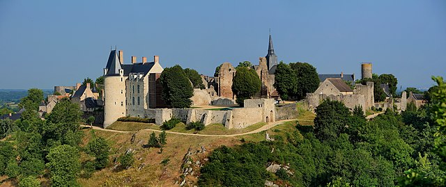
Sainte-Suzanne
- former commune in Mayenne, France
- Country:
- Postal Code: 53270
- Coordinates: 48° 5' 51" N, 0° 21' 11" E
- GPS tracks (wikiloc): [Link]
- Area: 23.14 sq km
- Population: 974
- Web site: [Link]