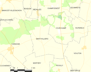
Champcenest (Champcenest)
- commune in Seine-et-Marne, France
- Country:

- Postal Code: 77560
- Coordinates: 48° 40' 11" N, 3° 16' 55" E


- GPS tracks (wikiloc): [Link]
- Area: 12.46 sq km
- Population: 210
- Web site: http://www.champcenest.fr
- Wikipedia en: wiki(en)
- Wikipedia: wiki(fr)
- Wikidata storage: Wikidata: Q1418637
- Wikipedia Commons Category: [Link]
- Freebase ID: [/m/02pt405]
- Freebase ID: [/m/02pt405]
- GeoNames ID: Alt: [6451184]
- GeoNames ID: Alt: [6451184]
- SIREN number: [217700806]
- SIREN number: [217700806]
- BnF ID: [15275421x]
- BnF ID: [15275421x]
- PACTOLS thesaurus ID: [pcrtgk7T3Hl6qv]
- PACTOLS thesaurus ID: [pcrtgk7T3Hl6qv]
- INSEE municipality code: 77080
- INSEE municipality code: 77080
Shares border with regions:


Beton-Bazoches
- commune in Seine-et-Marne, France
- Country:

- Postal Code: 77320
- Coordinates: 48° 42' 5" N, 3° 14' 39" E


- GPS tracks (wikiloc): [Link]
- Area: 18.32 sq km
- Population: 883
- Web site: [Link]


Bezalles
- commune in Seine-et-Marne, France
- Country:

- Postal Code: 77970
- Coordinates: 48° 40' 42" N, 3° 14' 34" E


- GPS tracks (wikiloc): [Link]
- Area: 2.66 sq km
- Population: 254


Rupéreux
- commune in Seine-et-Marne, France
- Country:

- Postal Code: 77560
- Coordinates: 48° 38' 9" N, 3° 19' 55" E


- GPS tracks (wikiloc): [Link]
- Area: 6.33 sq km
- Population: 102


Courtacon
- commune in Seine-et-Marne, France
- Country:

- Postal Code: 77560
- Coordinates: 48° 41' 44" N, 3° 17' 28" E


- GPS tracks (wikiloc): [Link]
- Area: 11.88 sq km
- Population: 258
- Web site: [Link]


Saint-Hilliers
- commune in Seine-et-Marne, France
- Country:

- Postal Code: 77160
- Coordinates: 48° 37' 16" N, 3° 15' 24" E


- GPS tracks (wikiloc): [Link]
- Area: 19.13 sq km
- Population: 468


Les Marêts
- commune in Seine-et-Marne, France
- Country:

- Postal Code: 77560
- Coordinates: 48° 40' 15" N, 3° 18' 50" E


- GPS tracks (wikiloc): [Link]
- Area: 5.38 sq km
- Population: 151


Courchamp
- commune in Seine-et-Marne, France
- Country:

- Postal Code: 77560
- Coordinates: 48° 38' 11" N, 3° 17' 13" E


- GPS tracks (wikiloc): [Link]
- Area: 12.41 sq km
- Population: 157
