Chantelouve (Chantelouve)
- commune in Isère, France
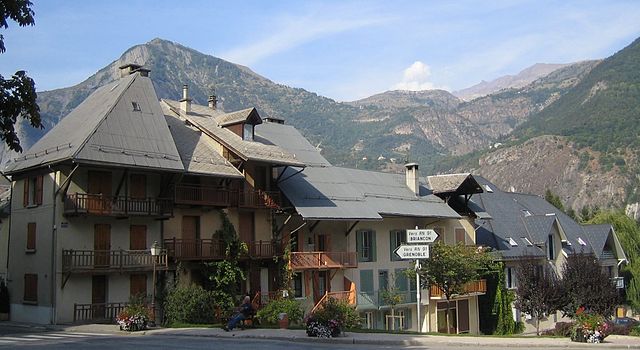
Chantelouve, located in the Isère department of France, is a wonderful destination for hiking enthusiasts, especially those looking to explore the stunning landscapes of the French Alps. Here are some highlights and tips for hiking in this area:
Scenic Trails
- Circuit de Chantelouve: This popular hiking route offers panoramic views of the Vercors range and the surrounding valleys. The trail is well-marked and can be enjoyed by hikers of various skill levels.
- Les Sentiers des Crêtes: This trail takes you along ridges with breathtaking views, perfect for both short excursions and longer day hikes. The paths can vary in difficulty, so check the route before you go.
Natural Beauty
Chantelouve is known for its beautiful alpine meadows, rugged cliffs, and diverse flora and fauna. Keep an eye out for local wildlife, including birds and possibly even deer. Spring and summer are particularly stunning times to visit, as wildflowers bloom brightly across the landscape.
Access and Facilities
- Getting There: Chantelouve is accessible by car, and there are often parking facilities available near trailheads.
- Amenities: Check for local accommodations if you plan to stay overnight. There may be gîtes (guesthouses) or camping options available in the vicinity.
Safety Tips
- Weather Preparedness: Mountain weather can change rapidly, so check forecasts and be prepared with appropriate clothing and gear.
- Stay Hydrated: Bring enough water, as some trails may lack reliable water sources.
- Trail Research: Familiarize yourself with the trail difficulties and length to choose a hike that matches your fitness level and schedule.
Local Regulations
Be aware of local regulations regarding wildlife and trail usage. Stick to marked paths to minimize impact on the environment and respect any guidelines provided.
Chantelouve offers a serene and beautiful hiking experience suitable for nature lovers, families, and adventure seekers alike. Enjoy your hike!
- Country:

- Postal Code: 38740
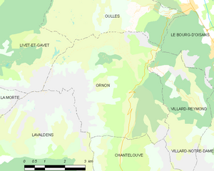
- Coordinates: 44° 59' 2" N, 5° 58' 6" E


- GPS tracks (wikiloc): [Link]
- Area: 33.41 sq km
- Population: 80
- Web site: http://www.mairie-chantelouve.fr
- Wikipedia en: wiki(en)
- Wikipedia: wiki(fr)
- Wikidata storage: Wikidata: Q1069620
- Wikipedia Commons Category: [Link]
- Freebase ID: [/m/03g_1gr]
- GeoNames ID: Alt: [6616651]
- SIREN number: [213800733]
- BnF ID: [152579023]
- INSEE municipality code: 38073
Shares border with regions:


Lavaldens
- commune in Isère, France
Lavaldens is a beautiful destination for hiking enthusiasts, located in the stunning region of the Italian Alps, specifically within the Province of Trento. The area is known for its picturesque landscapes, charming villages, and a variety of trails suitable for different levels of hikers. Here are some key points to consider when hiking in Lavaldens:...
- Country:

- Postal Code: 38350
- Coordinates: 44° 58' 58" N, 5° 53' 15" E


- GPS tracks (wikiloc): [Link]
- Area: 41.4 sq km
- Population: 163


Le Périer
- commune in Isère, France
Le Périer is a charming village located in the Isère department of the Auvergne-Rhône-Alpes region in southeastern France. It's situated near the Vercors Regional Natural Park, which offers a variety of hiking opportunities for outdoor enthusiasts....
- Country:

- Postal Code: 38740
- Coordinates: 44° 56' 13" N, 5° 58' 24" E


- GPS tracks (wikiloc): [Link]
- Area: 47.99 sq km
- Population: 137


Villard-Reymond
- commune in Isère, France
Villard-Reymond is a picturesque mountain village located in the French Alps, specifically in the Isère department. Known for its stunning scenery, the area offers a variety of hiking opportunities for all levels of experience. Here are some highlights of hiking in and around Villard-Reymond:...
- Country:

- Postal Code: 38520
- Coordinates: 45° 2' 2" N, 6° 1' 6" E


- GPS tracks (wikiloc): [Link]
- Area: 11.21 sq km
- Population: 43
- Web site: [Link]


Villard-Notre-Dame
- commune in Isère, France
Villard-Notre-Dame is a beautiful destination located in the French Alps, specifically in the Écrins National Park. This area is renowned for its stunning alpine landscapes, rich biodiversity, and a variety of outdoor activities, including hiking....
- Country:

- Postal Code: 38520
- Coordinates: 45° 1' 9" N, 6° 2' 38" E


- GPS tracks (wikiloc): [Link]
- Area: 14.06 sq km
- Population: 26
- Web site: [Link]


Ornon
- commune in Isère, France
Ornon is a lesser-known area that offers unique hiking opportunities, especially for those seeking a more tranquil outdoor experience. Located in the French Alps, the region is characterized by its stunning landscapes, dense forests, and diverse wildlife....
- Country:

- Postal Code: 38520
- Coordinates: 45° 2' 28" N, 5° 58' 40" E


- GPS tracks (wikiloc): [Link]
- Area: 11.6 sq km
- Population: 133


Le Bourg-d'Oisans
- commune in Isère, France
Le Bourg-d'Oisans is a charming commune located in the French Alps, nestled between the Oisans mountain range and the breathtaking Ecrins National Park. It's an excellent base for those who enjoy hiking, as it offers a variety of trails suitable for all experience levels, from beginner to advanced....
- Country:

- Postal Code: 38520
- Coordinates: 45° 3' 19" N, 6° 1' 46" E


- GPS tracks (wikiloc): [Link]
- Area: 35.75 sq km
- Population: 3239
- Web site: [Link]

