Charcé-Saint-Ellier-sur-Aubance (Charcé-Saint-Ellier-sur-Aubance)

- former commune in Maine-et-Loire, France
- Country:

- Postal Code: 49320
- Coordinates: 47° 21' 21" N, 0° 24' 37" E


- GPS tracks (wikiloc): [Link]
- AboveSeaLevel: 82 м m
- Area: 16.84 sq km
- Population: 772
- Web site: http://www.charce-saint-ellier-sur-aubance.fr
- Wikipedia en: wiki(en)
- Wikipedia: wiki(fr)
- Wikidata storage: Wikidata: Q761612
- Wikipedia Commons Category: [Link]
- Freebase ID: [/m/03qcpb6]
- GeoNames ID: Alt: [3026690]
- BnF ID: [15261680t]
- INSEE municipality code: 49078
Shares border with regions:

Saint-Saturnin-sur-Loire
- former commune in Maine-et-Loire, France
- Country:
- Postal Code: 49320
- Coordinates: 47° 23' 42" N, 0° 26' 9" E
- GPS tracks (wikiloc): [Link]
- Area: 11.94 sq km
- Population: 1389
- Web site: [Link]

Saulgé-l'Hôpital
- former commune in Maine-et-Loire, France
- Country:
- Postal Code: 49320
- Coordinates: 47° 17' 45" N, 0° 22' 57" E
- GPS tracks (wikiloc): [Link]
- Area: 6.6 sq km
- Population: 608
- Web site: [Link]


Les Alleuds
- former commune in Maine-et-Loire, France
- Country:
- Postal Code: 49320
- Coordinates: 47° 19' 10" N, 0° 24' 34" E
- GPS tracks (wikiloc): [Link]
- Area: 10.47 sq km
- Population: 886
- Web site: [Link]
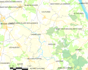
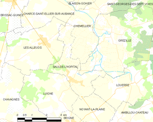
Chemellier
- former commune in Maine-et-Loire, France
- Country:
- Postal Code: 49320
- Coordinates: 47° 20' 27" N, 0° 21' 30" E
- GPS tracks (wikiloc): [Link]
- Area: 10.99 sq km
- Population: 821


Brissac-Quincé
- former commune in Maine-et-Loire, France
- Country:
- Postal Code: 49320
- Coordinates: 47° 21' 18" N, 0° 26' 56" E
- GPS tracks (wikiloc): [Link]
- AboveSeaLevel: 59 м m
- Area: 9.76 sq km
- Population: 3066
- Web site: [Link]