Chassignieu (Chassignieu)

- commune in Isère, France
 Hiking in Chassignieu
Chassignieu is a small commune located in the Auvergne-Rhône-Alpes region of France, which offers scenic trails and beautiful natural surroundings, making it an appealing destination for hiking enthusiasts. Here are some key points to consider if you're planning to hike in and around Chassignieu:
Scenic Trails
- Variety of Terrain: The region typically features rolling hills, scenic forests, and open fields, offering a variety of terrains that can suit different hiking levels, from easy walks to more challenging hikes.
- Views: Many trails provide stunning views of the surrounding landscape, including the Rhône Valley and the nearby mountains.
Wildlife and Flora
- The area is home to diverse plant and animal life, allowing hikers to enjoy the beauty of nature. Keep an eye out for local wildlife such as deer, birds, and various flora.
Local Hiking Routes
- While specific trails can vary, hiking routes are often well-marked. You may want to check local resources or maps for detailed trails. Some popular nearby hiking spots could be in the larger regional parks or nature reserves.
Recommendations
- Safety: Always wear appropriate footwear, check the weather forecast before you head out, and take essential gear such as water, snacks, and a first-aid kit.
- Local Guides: Consider hiring a local guide or joining a group if you’re unfamiliar with the area. This can enhance your experience and provide insights into the local environment.
- Respect Nature: Follow the Leave No Trace principles to keep the area pristine for future hikers.
Cultural Experience
- After hiking, take the opportunity to explore Chassignieu and its surroundings. You can enjoy local cuisine, visit historical sites, or meet the friendly locals.
Accessibility
- Chassignieu's location makes it accessible from major cities like Lyon, making it a suitable destination for day trips or weekend getaways.
When planning your hike, be sure to check local regulations, trail conditions, and any potential guided options available in the area. Happy hiking!
- Country:

- Postal Code: 38730
- Coordinates: 45° 30' 1" N, 5° 30' 16" E


- GPS tracks (wikiloc): [Link]
- Area: 5.17 sq km
- Population: 221
- Wikipedia en: wiki(en)
- Wikipedia: wiki(fr)
- Wikidata storage: Wikidata: Q573977
- Wikipedia Commons Category: [Link]
- Freebase ID: [/m/03nvglz]
- GeoNames ID: Alt: [6448754]
- SIREN number: [213800899]
- BnF ID: [15257916s]
- INSEE municipality code: 38089
Shares border with regions:


Valencogne
- commune in Isère, France
Hiking in Valencogne
Valencogne is a lesser-known but beautiful destination for hiking, located in the French Alps. Here are some highlights and tips for hiking in this area:...
- Country:
- Postal Code: 38730
- Coordinates: 45° 29' 57" N, 5° 32' 24" E
- GPS tracks (wikiloc): [Link]
- Area: 7.55 sq km
- Population: 662
- Web site: [Link]


Saint-Ondras
- commune in Isère, France
Hiking in Saint-Ondras
Saint-Ondras is a small commune located in the Isère department in the Auvergne-Rhône-Alpes region of France. While it may not be as well-known for hiking as some other areas in the region, it offers opportunities for outdoor enthusiasts seeking beautiful landscapes and tranquility....
- Country:
- Postal Code: 38490
- Coordinates: 45° 31' 4" N, 5° 32' 49" E
- GPS tracks (wikiloc): [Link]
- Area: 8.15 sq km
- Population: 621

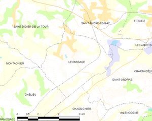
Le Passage
- commune in Isère, France
Hiking in Le Passage
Le Passage is a small village located in the Isère department of the Auvergne-Rhône-Alpes region in southeastern France. While it may not be as widely recognized as some larger hiking destinations, the surrounding Isère region offers a wealth of hiking opportunities, particularly in the nearby Vercors and Chartreuse mountain ranges....
- Country:
- Postal Code: 38490
- Coordinates: 45° 31' 58" N, 5° 30' 43" E
- GPS tracks (wikiloc): [Link]
- Area: 6.68 sq km
- Population: 783
- Web site: [Link]

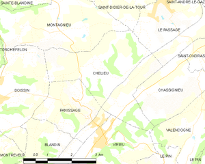
Chélieu
- commune in Isère, France
Hiking in Chélieu
Chélieu, located in the Isère department of the Auvergne-Rhône-Alpes region in France, offers beautiful landscapes and opportunities for hiking enthusiasts. The area is characterized by its stunning mountainous terrain, with the Chartreuse Mountains nearby providing a range of trails suitable for different skill levels....
- Country:
- Postal Code: 38730
- Coordinates: 45° 30' 44" N, 5° 28' 33" E
- GPS tracks (wikiloc): [Link]
- AboveSeaLevel: 607 м m
- Area: 10.13 sq km
- Population: 674
- Web site: [Link]