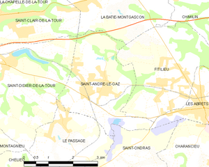
Le Passage (Le Passage)

- commune in Isère, France
 Hiking in Le Passage
Le Passage is a small village located in the Isère department of the Auvergne-Rhône-Alpes region in southeastern France. While it may not be as widely recognized as some larger hiking destinations, the surrounding Isère region offers a wealth of hiking opportunities, particularly in the nearby Vercors and Chartreuse mountain ranges.
Hiking Opportunities in and around Le Passage:
-
Scenic Trails: The Isère region boasts a variety of trails that cater to all levels of hikers. You can find gentle paths suitable for families, as well as more challenging routes for experienced hikers looking for a workout and stunning views.
-
Nearby Mountains: The Vercors Massif and Chartreuse Mountains are easily accessible. These ranges are known for their breathtaking landscapes, limestone cliffs, and diverse flora and fauna.
-
Natural Reserves: The Vercors Regional Natural Park offers many well-marked hiking trails. You can explore gorges, forests, and picturesque villages along the way. Look for trails leading to prominent landmarks, such as the Grand Veymont or the connected but distinct peaks of the Chartreuse Mountains.
-
Wildlife and Nature: While hiking, you may encounter various wildlife, including chamois, deer, and numerous bird species. The biodiversity in this region is quite impressive, making it an enriching experience for nature lovers.
-
Local Culture: If you're hiking in the area, take time to explore the local culture. You might find small mountain farms offering local delicacies, such as cheeses and cured meats, which are perfect for a scenic picnic.
Tips for Hiking in Le Passage:
- Prepare for Weather: Mountain weather can change rapidly, so it's essential to check the forecast before heading out and dress in layers.
- Trail Maps: Consider obtaining local trail maps or using smartphone apps that offer detailed hiking routes to stay oriented.
- Safety: Always inform someone of your hiking plans, especially if venturing into more remote areas. Carry a first aid kit, sufficient water, and snacks.
- Leave No Trace: Respect the natural environment by following Leave No Trace principles, ensuring that the area remains beautiful for future hikers.
If you're planning a hiking trip to Le Passage, take the opportunity to explore the natural beauty and culture of the Isère region!
- Country:

- Postal Code: 38490
- Coordinates: 45° 31' 58" N, 5° 30' 43" E


- GPS tracks (wikiloc): [Link]
- Area: 6.68 sq km
- Population: 783
- Web site: http://www.le-passage-en-dauphine.fr
- Wikipedia en: wiki(en)
- Wikipedia: wiki(fr)
- Wikidata storage: Wikidata: Q1068856
- Wikipedia Commons Category: [Link]
- Freebase ID: [/m/03nvkm6]
- GeoNames ID: Alt: [6455944]
- SIREN number: [213802960]
- BnF ID: [152581086]
- INSEE municipality code: 38296
Shares border with regions:


Saint-Didier-de-la-Tour
- commune in Isère, France
Hiking in Saint-Didier-de-la-Tour
Saint-Didier-de-la-Tour is a charming commune located in the Isère department of the Auvergne-Rhône-Alpes region in southeastern France. The area is characterized by its natural beauty, including rolling hills, lush greenery, and proximity to the mountains, making it a great spot for hiking enthusiasts....
- Country:
- Postal Code: 38110
- Coordinates: 45° 33' 19" N, 5° 28' 59" E
- GPS tracks (wikiloc): [Link]
- Area: 14.63 sq km
- Population: 2003
- Web site: [Link]


Saint-Ondras
- commune in Isère, France
Hiking in Saint-Ondras
Saint-Ondras is a small commune located in the Isère department in the Auvergne-Rhône-Alpes region of France. While it may not be as well-known for hiking as some other areas in the region, it offers opportunities for outdoor enthusiasts seeking beautiful landscapes and tranquility....
- Country:
- Postal Code: 38490
- Coordinates: 45° 31' 4" N, 5° 32' 49" E
- GPS tracks (wikiloc): [Link]
- Area: 8.15 sq km
- Population: 621

Saint-André-le-Gaz
- commune in Isère, France
Hiking in Saint-André-le-Gaz
Saint-André-le-Gaz, located in the Auvergne-Rhône-Alpes region of France, offers a delightful experience for hikers and outdoor enthusiasts. Nestled at the foothills of the Chartreuse Mountains and near the Rhône Valley, this area provides a range of trails suitable for various skill levels, from leisurely walks to more challenging hikes....
- Country:
- Postal Code: 38490
- Coordinates: 45° 32' 56" N, 5° 32' 3" E
- GPS tracks (wikiloc): [Link]
- Area: 8.89 sq km
- Population: 2783
- Web site: [Link]


Chassignieu
- commune in Isère, France
Hiking in Chassignieu
Chassignieu is a small commune located in the Auvergne-Rhône-Alpes region of France, which offers scenic trails and beautiful natural surroundings, making it an appealing destination for hiking enthusiasts. Here are some key points to consider if you're planning to hike in and around Chassignieu:...
- Country:
- Postal Code: 38730
- Coordinates: 45° 30' 1" N, 5° 30' 16" E
- GPS tracks (wikiloc): [Link]
- Area: 5.17 sq km
- Population: 221

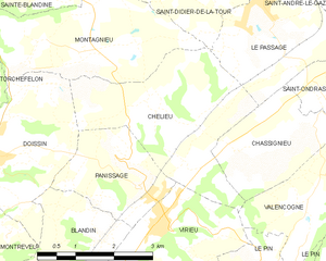
Chélieu
- commune in Isère, France
Hiking in Chélieu
Chélieu, located in the Isère department of the Auvergne-Rhône-Alpes region in France, offers beautiful landscapes and opportunities for hiking enthusiasts. The area is characterized by its stunning mountainous terrain, with the Chartreuse Mountains nearby providing a range of trails suitable for different skill levels....
- Country:
- Postal Code: 38730
- Coordinates: 45° 30' 44" N, 5° 28' 33" E
- GPS tracks (wikiloc): [Link]
- AboveSeaLevel: 607 м m
- Area: 10.13 sq km
- Population: 674
- Web site: [Link]