Chauvigné (Chauvigné)

- commune in Ille-et-Vilaine, France
- Country:

- Postal Code: 35490
- Coordinates: 48° 22' 33" N, 1° 27' 37" E


- GPS tracks (wikiloc): [Link]
- Area: 17.71 sq km
- Population: 854
- Wikipedia en: wiki(en)
- Wikipedia: wiki(fr)
- Wikidata storage: Wikidata: Q1011035
- Wikipedia Commons Category: [Link]
- Freebase ID: [/m/09hm8s]
- Freebase ID: [/m/09hm8s]
- GeoNames ID: Alt: [6448551]
- GeoNames ID: Alt: [6448551]
- SIREN number: [213500754]
- SIREN number: [213500754]
- VIAF ID: Alt: [247000907]
- VIAF ID: Alt: [247000907]
- OSM relation ID: [972691]
- OSM relation ID: [972691]
- MusicBrainz area ID: [847ce564-f46c-4388-b69a-3ec31c4963b6]
- MusicBrainz area ID: [847ce564-f46c-4388-b69a-3ec31c4963b6]
- INSEE municipality code: 35075
- INSEE municipality code: 35075
Shares border with regions:


Romazy
- commune in Ille-et-Vilaine, France
- Country:
- Postal Code: 35490
- Coordinates: 48° 22' 32" N, 1° 29' 49" E
- GPS tracks (wikiloc): [Link]
- Area: 7.18 sq km
- Population: 273

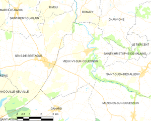
Vieux-Vy-sur-Couesnon
- commune in Ille-et-Vilaine, France
- Country:
- Postal Code: 35490
- Coordinates: 48° 20' 30" N, 1° 29' 22" E
- GPS tracks (wikiloc): [Link]
- AboveSeaLevel: 65 м m
- Area: 21.56 sq km
- Population: 1171
- Web site: [Link]


Saint-Marc-le-Blanc
- commune in Ille-et-Vilaine, France
- Country:
- Postal Code: 35460
- Coordinates: 48° 21' 52" N, 1° 24' 34" E
- GPS tracks (wikiloc): [Link]
- Area: 17.53 sq km
- Population: 1376


Tremblay
- commune in Ille-et-Vilaine, France
- Country:
- Postal Code: 35460
- Coordinates: 48° 25' 20" N, 1° 28' 33" E
- GPS tracks (wikiloc): [Link]
- Area: 36.22 sq km
- Population: 1566
- Web site: [Link]

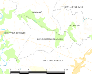
Saint-Christophe-de-Valains
- commune in Ille-et-Vilaine, France
- Country:
- Postal Code: 35140
- Coordinates: 48° 20' 34" N, 1° 26' 50" E
- GPS tracks (wikiloc): [Link]
- AboveSeaLevel: 75 м m
- Area: 3.27 sq km
- Population: 220
- Web site: [Link]

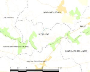
Le Tiercent
- commune in Ille-et-Vilaine, France
- Country:
- Postal Code: 35460
- Coordinates: 48° 20' 57" N, 1° 24' 23" E
- GPS tracks (wikiloc): [Link]
- Area: 3.7 sq km
- Population: 164