Chelun (Chelun)

- commune in Ille-et-Vilaine, France
- Country:

- Postal Code: 35640
- Coordinates: 47° 51' 18" N, 1° 13' 27" E


- GPS tracks (wikiloc): [Link]
- Area: 11.25 sq km
- Population: 348
- Web site: http://www.mairie-chelun.com
- Wikipedia en: wiki(en)
- Wikipedia: wiki(fr)
- Wikidata storage: Wikidata: Q1011143
- Wikipedia Commons Category: [Link]
- Freebase ID: [/m/03mdxhx]
- Freebase ID: [/m/03mdxhx]
- GeoNames ID: Alt: [6448553]
- GeoNames ID: Alt: [6448553]
- SIREN number: [213500770]
- SIREN number: [213500770]
- BnF ID: [15257021w]
- BnF ID: [15257021w]
- OSM relation ID: [108430]
- OSM relation ID: [108430]
- INSEE municipality code: 35077
- INSEE municipality code: 35077
Shares border with regions:


Rannée
- commune in Ille-et-Vilaine, France
- Country:
- Postal Code: 35130
- Coordinates: 47° 55' 26" N, 1° 14' 28" E
- GPS tracks (wikiloc): [Link]
- Area: 51.95 sq km
- Population: 1110

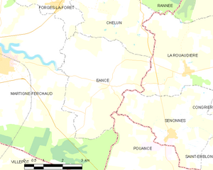
Eancé
- commune in Ille-et-Vilaine, France
- Country:
- Postal Code: 35640
- Coordinates: 47° 49' 19" N, 1° 14' 34" E
- GPS tracks (wikiloc): [Link]
- Area: 16.5 sq km
- Population: 405
- Web site: [Link]

Forges-la-Forêt
- commune in Ille-et-Vilaine, France
- Country:
- Postal Code: 35640
- Coordinates: 47° 51' 34" N, 1° 16' 53" E
- GPS tracks (wikiloc): [Link]
- Area: 6.04 sq km
- Population: 271


La Rouaudière
- commune in Mayenne, France
- Country:
- Postal Code: 53390
- Coordinates: 47° 49' 48" N, 1° 11' 31" E
- GPS tracks (wikiloc): [Link]
- Area: 19.02 sq km
- Population: 330