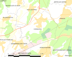
Chemaudin (Chemaudin)
- former commune in Doubs, France
Chemaudin is a picturesque area known for its beautiful landscapes and hiking trails. While it may not be as widely known as some other hiking destinations, it offers a variety of natural settings and trails suitable for different skill levels.
Hiking Trails
-
Beginner Trails:
- Easy, well-marked paths suitable for families and novice hikers. These trails often take you through scenic areas with gentle elevation changes.
-
Moderate Trails:
- These trails may include some elevation and varied terrain. They are suitable for those with a basic level of hiking experience and often lead to viewpoints or points of interest.
-
Challenging Trails:
- For seasoned hikers, there may be more strenuous routes that take you into rugged terrains. Always be prepared with proper gear and navigation skills if you choose this option.
Nature and Scenery
- Flora and Fauna: The area is typically abundant in local wildlife and flora, including various species of trees, plants, and birds. Keep an eye out for unique botanic aspects unique to the region.
- Scenic Views: Many trails will offer breathtaking views, especially if you venture to higher elevations. Sunrises and sunsets can be especially beautiful.
Tips for Hiking in Chemaudin
- Plan Ahead: Research the trails before your hike. Check for trail conditions and weather forecasts.
- Safety First: Always let someone know your hiking plans and estimated return time.
- Stay Hydrated: Carry enough water, especially on warmer days.
- Dress Appropriately: Wear suitable clothing and sturdy shoes designed for hiking. Layers are a good idea as temperatures can change.
- Leave No Trace: Follow local guidelines to protect the natural environment.
Local Amenities
- Look for nearby accommodations or facilities if you plan on a multi-day hike. There may also be local guiding services available if you prefer to have expert guidance.
Remember, hiking is not just about the destination but also about enjoying the journey and nature around you. Enjoy your time exploring Chemaudin!
- Country:

- Postal Code: 25320
- Coordinates: 47° 13' 26" N, 5° 53' 31" E


- GPS tracks (wikiloc): [Link]
- Area: 7.3 sq km
- Population: 1501
- Web site: http://www.chemaudin.fr
- Wikipedia en: wiki(en)
- Wikipedia: wiki(fr)
- Wikidata storage: Wikidata: Q837481
- Wikipedia Commons Category: [Link]
- Freebase ID: [/m/03mgs4m]
- Freebase ID: [/m/03mgs4m]
- GeoNames ID: Alt: [6429721]
- GeoNames ID: Alt: [6429721]
- BnF ID: [15252373r]
- BnF ID: [15252373r]
- INSEE municipality code: 25147
- INSEE municipality code: 25147
Shares border with regions:


Vaux-les-Prés
- former commune in Doubs, France
Vaux-les-Prés is a charming village located in the Vosges region of northeastern France, known for its picturesque landscapes and natural beauty. The area offers a variety of hiking opportunities suitable for different skill levels. Here are some highlights and tips for hiking in Vaux-les-Prés:...
- Country:

- Postal Code: 25770
- Coordinates: 47° 14' 10" N, 5° 53' 0" E


- GPS tracks (wikiloc): [Link]
- Area: 5.14 sq km
- Population: 362
- Web site: [Link]


Villers-Buzon
- commune in Doubs, France
Villers-Buzon is a small commune located in the Doubs department of the Bourgogne-Franche-Comté region in France. It is surrounded by beautiful natural landscapes that provide excellent hiking opportunities for various skill levels. Here are some key points regarding hiking in Villers-Buzon:...
- Country:

- Postal Code: 25170
- Coordinates: 47° 13' 39" N, 5° 51' 6" E


- GPS tracks (wikiloc): [Link]
- Area: 3.19 sq km
- Population: 250

