Chevaline (Chevaline)

- commune in Haute-Savoie, France
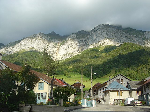
 Hiking in Chevaline
Chevaline, located in the Haute-Savoie region of France, is a picturesque village that lies at the edge of Lake Annecy, surrounded by stunning mountain scenery. It's an excellent destination for hiking enthusiasts, offering a variety of trails suitable for all levels of hikers. Here are some highlights and tips for hiking in Chevaline:
Scenic Trails
-
The Col de la Forclaz: This trail provides breathtaking views over Lake Annecy and the surrounding mountains. It's particularly popular for sunrise and sunset hikes. The trail can be quite steep but rewards you with stunning panoramic views.
-
Lac d'Annecy Circuit: For a more relaxed hike, consider the circuit around Lac d'Annecy. It's an easier path, perfect for families, with plenty of picnic spots and opportunities to enjoy the lake's beauty.
-
The Mont Veyrier Trail: A moderately challenging hike that offers spectacular views of the lake and the surrounding landscape. This trail intersects with various paths leading to the summit.
Tips for Hiking in Chevaline
- Seasonality: The best time for hiking in the area is during the spring (May to June) and fall (September to October), when the weather is mild, and the trails are less crowded.
- Prepare for Weather Changes: Mountain weather can be unpredictable. Always check the forecast, and dress in layers to accommodate temperature changes.
- Stay Hydrated: Carry plenty of water, especially on longer hikes, as some trails can be strenuous.
- Local Wildlife: Keep an eye out for local wildlife and respect their habitats. Avoid feeding animals and follow Leave No Trace principles.
- Maps and Guides: Consider bringing a hiking map or using a navigation app to help you stay on track, as some trails may not be well-marked.
Additional Activities
- Exploring Chevaline Village: Take some time to explore the charming village of Chevaline, enjoy local cuisine, or relax by the lake after your hike.
- Water Activities: Lake Annecy offers opportunities for swimming, kayaking, and paddleboarding if you're interested in combining hiking with water activities.
Hiking in Chevaline promises a rewarding experience with stunning scenery, a variety of trails, and the chance to connect with nature. Always make sure to check local resources for trail conditions and any specific regulations before heading out.
- Country:

- Postal Code: 74210
- Coordinates: 45° 45' 45" N, 6° 13' 11" E


- GPS tracks (wikiloc): [Link]
- Area: 14.16 sq km
- Population: 201
- Wikipedia en: wiki(en)
- Wikipedia: wiki(fr)
- Wikidata storage: Wikidata: Q818422
- Wikipedia Commons Category: [Link]
- Freebase ID: [/m/03ntytr]
- GeoNames ID: Alt: [6451043]
- SIREN number: [217400720]
- BnF ID: [15274331q]
- WOEID: [585671]
- INSEE municipality code: 74072
Shares border with regions:

Doucy-en-Bauges
- commune in Savoie, France
Hiking in Doucy-en-Bauges
Doucy-en-Bauges is a charming village situated in the Savoie department of the Auvergne-Rhône-Alpes region in France, nestled in the Bauges Massif Natural Regional Park. This area is known for its stunning landscapes, diverse ecosystems, and picturesque views, making it a great destination for hiking enthusiasts....
- Country:
- Postal Code: 73630
- Coordinates: 45° 41' 11" N, 6° 10' 7" E
- GPS tracks (wikiloc): [Link]
- AboveSeaLevel: 900 м m
- Area: 12.65 sq km
- Population: 97


Doussard
- commune in Haute-Savoie, France
Hiking in Doussard
Doussard, located in the Haute-Savoie region of France, is a picturesque town situated on the shores of Lake Annecy, surrounded by stunning alpine scenery. It serves as an excellent base for various outdoor activities, including hiking. Here are some aspects to consider if you're planning a hiking trip in Doussard:...
- Country:
- Postal Code: 74210
- Coordinates: 45° 46' 32" N, 6° 13' 14" E
- GPS tracks (wikiloc): [Link]
- Area: 20.14 sq km
- Population: 3625
- Web site: [Link]


Bellecombe-en-Bauges
- commune in Savoie, France
Hiking in Bellecombe-en-Bauges
Bellecombe-en-Bauges is a beautiful village located in the Bauges Mountains of the Auvergne-Rhône-Alpes region in France. Known for its stunning natural landscapes, it offers a variety of hiking opportunities suitable for different skill levels. Here are some highlights for hiking in this area:...
- Country:
- Postal Code: 73340
- Coordinates: 45° 44' 14" N, 6° 8' 32" E
- GPS tracks (wikiloc): [Link]
- AboveSeaLevel: 840 м m
- Area: 22.89 sq km
- Population: 664


Jarsy
- commune in Savoie, France
Hiking in Jarsy
Jarsy is a charming village located in the Savoie region of the French Alps, known for its beautiful natural landscapes and outdoor activities, including hiking. Here are some key points about hiking in Jarsy:...
- Country:
- Postal Code: 73630
- Coordinates: 45° 39' 25" N, 6° 10' 44" E
- GPS tracks (wikiloc): [Link]
- Area: 32.68 sq km
- Population: 270