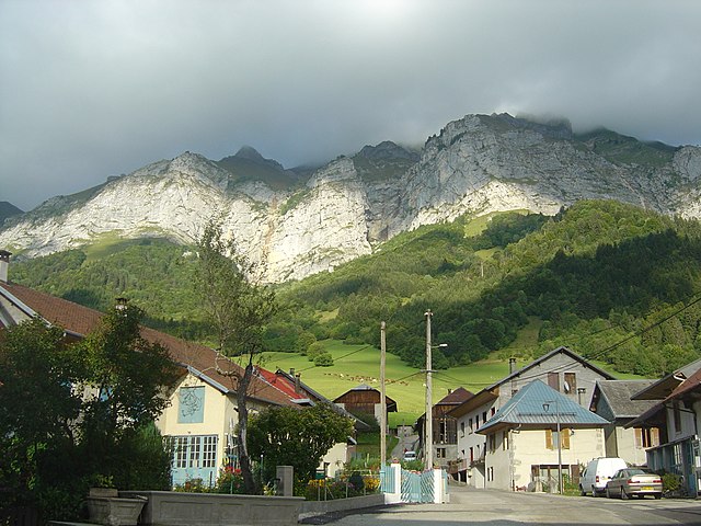
Bellecombe-en-Bauges (Bellecombe-en-Bauges)

- commune in Savoie, France
 Hiking in Bellecombe-en-Bauges
Bellecombe-en-Bauges is a beautiful village located in the Bauges Mountains of the Auvergne-Rhône-Alpes region in France. Known for its stunning natural landscapes, it offers a variety of hiking opportunities suitable for different skill levels. Here are some highlights for hiking in this area:
Scenic Trails
- Diverse Terrain: The area features a mix of lush forests, alpine meadows, and rocky terrains, providing breathtaking views of the surrounding mountains and valleys.
- Flora and Fauna: Hikers can explore rich biodiversity, including local wildlife and a variety of plant species, particularly during spring and summer.
Popular Hiking Routes
- The Col de la Forclaz: A popular trail that offers panoramic views and is accessible for various skill levels. The trail winds through picturesque landscapes and can serve as a great introduction to hiking in the region.
- La Cascade de la Tine: A shorter, family-friendly hike that leads to a beautiful waterfall. It's a lovely spot for a picnic and enjoying nature.
- Mont Revard: For those seeking a more challenging hike, the trails leading up to Mont Revard can provide a vigorous workout along with stunning views of Lake Bourget and the surrounding Alps.
Practical Information
- Trail Markings: Most trails are well-marked with signs and color codes, making navigation easier for hikers.
- Seasonal Considerations: Spring and summer are ideal for hiking, while winter may provide opportunities for snowshoeing. Always check trail conditions, especially after heavy snowfall or rain.
- Local Guides: If you’re new to the area or want to explore more remote trails, consider hiring a local guide who can provide insights into the landscape and safety tips.
Preparation
- Gear: Good hiking boots, weather-appropriate clothing, and plenty of water are essential. Depending on the season, trekking poles and other gear may be useful.
- Maps/Apps: While trails are generally well marked, carrying a map or using a hiking app can enhance safety and navigation.
Conclusion
Hiking in Bellecombe-en-Bauges provides a fantastic opportunity to immerse yourself in the natural beauty of the Alps. Whether you're a novice hiker or an experienced trekker, you'll find trails that challenge and inspire you. Always be sure to respect local guidelines, wildlife, and the environment during your hikes!
- Country:

- Postal Code: 73340
- Coordinates: 45° 44' 14" N, 6° 8' 32" E


- GPS tracks (wikiloc): [Link]
- AboveSeaLevel: 840 м m
- Area: 22.89 sq km
- Population: 664
- Wikipedia en: wiki(en)
- Wikipedia: wiki(fr)
- Wikidata storage: Wikidata: Q815889
- Wikipedia Commons Category: [Link]
- Freebase ID: [/m/03npg10]
- GeoNames ID: Alt: [6617570]
- SIREN number: [217300367]
- BnF ID: [15273972q]
- VIAF ID: Alt: [123560419]
- Library of Congress authority ID: Alt: [no2009060872]
- INSEE municipality code: 73036
Shares border with regions:


Entrevernes
- commune in Haute-Savoie, France
Hiking in Entrevernes
Entrevernes is a picturesque commune located in the Auvergne-Rhône-Alpes region of France, nestled at the foot of the majestic French Alps. The area is known for its stunning natural landscapes, making it an excellent destination for hiking enthusiasts of all levels....
- Country:
- Postal Code: 74410
- Coordinates: 45° 47' 43" N, 6° 11' 19" E
- GPS tracks (wikiloc): [Link]
- Area: 8.31 sq km
- Population: 220


Arith
- commune in Savoie, France
Hiking in Arith
Arith is a charming village located in the Savoie region of France, nestled in the French Alps. It's surrounded by stunning natural landscapes, making it a great destination for hiking enthusiasts....
- Country:
- Postal Code: 73340
- Coordinates: 45° 42' 57" N, 6° 5' 3" E
- GPS tracks (wikiloc): [Link]
- Area: 24.27 sq km
- Population: 439


Lescheraines
- commune in Savoie, France
Hiking in Lescheraines
Lescheraines is a charming village located in the Savoie department in the Auvergne-Rhône-Alpes region of France. It is situated near the beautiful Lac du Bourget, making it a fantastic starting point for various hiking adventures. Here are some highlights and tips for hiking in and around Lescheraines:...
- Country:
- Postal Code: 73340
- Coordinates: 45° 42' 30" N, 6° 6' 18" E
- GPS tracks (wikiloc): [Link]
- Area: 8.17 sq km
- Population: 773
- Web site: [Link]


Allèves
- commune in Haute-Savoie, France
Hiking in Allèves
Allèves is a beautiful area surrounded by the stunning landscapes of the French Alps. It offers various hiking opportunities catering to different skill levels, from easy walks to more challenging treks. Here are some key points about hiking in Allèves:...
- Country:
- Postal Code: 74540
- Coordinates: 45° 45' 8" N, 6° 4' 49" E
- GPS tracks (wikiloc): [Link]
- Area: 8.81 sq km
- Population: 400
- Web site: [Link]

Doucy-en-Bauges
- commune in Savoie, France
Hiking in Doucy-en-Bauges
Doucy-en-Bauges is a charming village situated in the Savoie department of the Auvergne-Rhône-Alpes region in France, nestled in the Bauges Massif Natural Regional Park. This area is known for its stunning landscapes, diverse ecosystems, and picturesque views, making it a great destination for hiking enthusiasts....
- Country:
- Postal Code: 73630
- Coordinates: 45° 41' 11" N, 6° 10' 7" E
- GPS tracks (wikiloc): [Link]
- AboveSeaLevel: 900 м m
- Area: 12.65 sq km
- Population: 97


Doussard
- commune in Haute-Savoie, France
Hiking in Doussard
Doussard, located in the Haute-Savoie region of France, is a picturesque town situated on the shores of Lake Annecy, surrounded by stunning alpine scenery. It serves as an excellent base for various outdoor activities, including hiking. Here are some aspects to consider if you're planning a hiking trip in Doussard:...
- Country:
- Postal Code: 74210
- Coordinates: 45° 46' 32" N, 6° 13' 14" E
- GPS tracks (wikiloc): [Link]
- Area: 20.14 sq km
- Population: 3625
- Web site: [Link]


La Chapelle-Saint-Maurice
- commune in Haute-Savoie, France
Hiking in La Chapelle-Saint-Maurice
La Chapelle-Saint-Maurice is a picturesque commune located in the Savoie department in the Auvergne-Rhône-Alpes region of France. It is situated in the Alps, making it an excellent destination for hiking enthusiasts....
- Country:
- Postal Code: 74410
- Coordinates: 45° 46' 43" N, 6° 9' 1" E
- GPS tracks (wikiloc): [Link]
- Area: 6.48 sq km
- Population: 128


Chevaline
- commune in Haute-Savoie, France
Hiking in Chevaline
Chevaline, located in the Haute-Savoie region of France, is a picturesque village that lies at the edge of Lake Annecy, surrounded by stunning mountain scenery. It's an excellent destination for hiking enthusiasts, offering a variety of trails suitable for all levels of hikers. Here are some highlights and tips for hiking in Chevaline:...
- Country:
- Postal Code: 74210
- Coordinates: 45° 45' 45" N, 6° 13' 11" E
- GPS tracks (wikiloc): [Link]
- Area: 14.16 sq km
- Population: 201


La Motte-en-Bauges
- commune in Savoie, France
Hiking in La Motte-en-Bauges
La Motte-en-Bauges is a charming village located within the Bauges Regional Natural Park in the French Alps, offering a variety of scenic hiking opportunities. The region is known for its breathtaking landscapes, diverse flora and fauna, and stunning views of nearby mountain ranges....
- Country:
- Postal Code: 73340
- Coordinates: 45° 42' 7" N, 6° 7' 46" E
- GPS tracks (wikiloc): [Link]
- AboveSeaLevel: 687 м m
- Area: 9.96 sq km
- Population: 486
- Web site: [Link]


Le Châtelard
- commune in Savoie, France
Hiking in Le Châtelard
Le Châtelard is a charming destination located in the Savoie region of the French Alps, known for its stunning natural beauty and excellent hiking opportunities. Here are some details about hiking in this area:...
- Country:
- Postal Code: 73630
- Coordinates: 45° 41' 7" N, 6° 8' 14" E
- GPS tracks (wikiloc): [Link]
- Area: 18 sq km
- Population: 671
- Web site: [Link]


Leschaux
- commune in Haute-Savoie, France
Hiking in Leschaux
Leschaux is a charming area located in the French Alps, known for its stunning natural beauty and excellent hiking opportunities. This region is nestled near the Mont Blanc massif, making it an excellent base for outdoor enthusiasts looking to explore the surrounding mountains....
- Country:
- Postal Code: 74320
- Coordinates: 45° 46' 22" N, 6° 7' 33" E
- GPS tracks (wikiloc): [Link]
- Area: 12.52 sq km
- Population: 283


Lathuile
- commune in Haute-Savoie, France
Hiking in Lathuile
Lathuile is a charming village located in the Annecy region of the French Alps, known for its stunning landscapes and outdoor activities, including hiking. It’s nestled near the shores of Lake Annecy, one of the cleanest lakes in Europe, providing a beautiful backdrop for hiking adventures....
- Country:
- Postal Code: 74210
- Coordinates: 45° 46' 57" N, 6° 12' 10" E
- GPS tracks (wikiloc): [Link]
- Area: 8.76 sq km
- Population: 1041
- Web site: [Link]