Chinon (Chinon)
- commune in Indre-et-Loire, France
- Country:

- Postal Code: 37500
- Coordinates: 47° 10' 1" N, 0° 14' 34" E


- GPS tracks (wikiloc): [Link]
- AboveSeaLevel: 37 м m
- Area: 39.02 sq km
- Population: 8101
- Web site: http://www.ville-chinon.com/
- Wikipedia en: wiki(en)
- Wikipedia: wiki(fr)
- Wikidata storage: Wikidata: Q194138
- Wikipedia Commons Category: [Link]
- Freebase ID: [/m/0jvcc]
- GeoNames ID: Alt: [6448684]
- SIREN number: [213700727]
- BnF ID: [152576237]
- VIAF ID: Alt: [138432031]
- OSM relation ID: [105284]
- GND ID: Alt: [4009973-8]
- Library of Congress authority ID: Alt: [n84238947]
- MusicBrainz area ID: [1df0553b-c6a7-4cb0-aade-f975c9e6684f]
- Encyclopædia Britannica Online ID: [place/Chinon]
- Gran Enciclopèdia Catalana ID: [0017594]
- INSEE municipality code: 37072
- US National Archives Identifier: 10045050
Shares border with regions:


Cravant-les-Côteaux
- commune in Indre-et-Loire, France
- Country:

- Postal Code: 37500
- Coordinates: 47° 9' 28" N, 0° 20' 48" E


- GPS tracks (wikiloc): [Link]
- Area: 38.21 sq km
- Population: 696
- Web site: [Link]

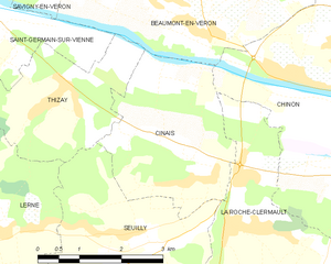
Cinais
- commune in Indre-et-Loire, France
- Country:

- Postal Code: 37500
- Coordinates: 47° 8' 54" N, 0° 10' 55" E


- GPS tracks (wikiloc): [Link]
- Area: 8.77 sq km
- Population: 426
- Web site: [Link]


Beaumont-en-Véron
- commune in Indre-et-Loire, France
- Country:

- Postal Code: 37420
- Coordinates: 47° 11' 45" N, 0° 11' 10" E


- GPS tracks (wikiloc): [Link]
- Area: 18.83 sq km
- Population: 2699
- Web site: [Link]


Rivière
- commune in Indre-et-Loire, France
- Country:

- Postal Code: 37500
- Coordinates: 47° 8' 45" N, 0° 16' 46" E


- GPS tracks (wikiloc): [Link]
- Area: 3.66 sq km
- Population: 733


Saint-Benoît-la-Forêt
- commune in Indre-et-Loire, France
- Country:

- Postal Code: 37500
- Coordinates: 47° 13' 14" N, 0° 19' 21" E


- GPS tracks (wikiloc): [Link]
- Area: 35.25 sq km
- Population: 857
- Web site: [Link]


La Roche-Clermault
- commune in Indre-et-Loire, France
- Country:

- Postal Code: 37500
- Coordinates: 47° 8' 16" N, 0° 12' 9" E


- GPS tracks (wikiloc): [Link]
- Area: 18.03 sq km
- Population: 517


Huismes
- commune in Indre-et-Loire, France
- Country:

- Postal Code: 37420
- Coordinates: 47° 13' 57" N, 0° 15' 9" E


- GPS tracks (wikiloc): [Link]
- Area: 23.82 sq km
- Population: 1537
- Web site: [Link]
