%20banner.jpg)
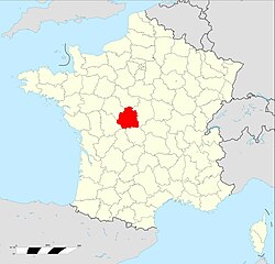
Indre-et-Loire (Indre-et-Loire)


- French department
- Country:

- Capital: Tours
- Coordinates: 47° 15' 0" N, 0° 40' 0" E


- GPS tracks (wikiloc): [Link]
- Area: 6127 sq km
- Population: 604966
- Web site: http://www.indre-et-loire.pref.gouv.fr/
- Wikipedia en: wiki(en)
- Wikipedia: wiki(fr)
- Wikidata storage: Wikidata: Q12556
- Wikipedia Commons Gallery: [Link]
- Wikipedia Commons Category: [Link]
- Wikipedia Commons Maps Category: [Link]
- Freebase ID: [/m/0hrby]
- GeoNames ID: Alt: [3012804]
- SIREN number: [223700014]
- BnF ID: [120434065]
- VIAF ID: Alt: [127494899]
- OSM relation ID: [7408]
- GND ID: Alt: [4253420-3]
- archINFORM location ID: [2746]
- Library of Congress authority ID: Alt: [n83214250]
- PACTOLS thesaurus ID: [pcrtWNoFaSfrI0]
- MusicBrainz area ID: [6b0ffdc7-2997-49d1-a343-f43786471cb0]
- SUDOC authorities ID: [028639766]
- Encyclopædia Britannica Online ID: [place/Indre-et-Loire]
- Gran Enciclopèdia Catalana ID: [0033615]
- data.gouv.fr org ID: [indre]
- NUTS code: [FR244]
- INSEE department code: [37]
- ISO 3166-2 code: FR-37
Includes regions:

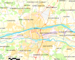
Tours
- commune in Indre-et-Loire, France
- Country:
- Postal Code: 37200; 37100; 37000
- Local Dialing Code: 247
- Coordinates: 47° 23' 34" N, 0° 41' 18" E
- GPS tracks (wikiloc): [Link]
- AboveSeaLevel: 76 м m
- Area: 34.36 sq km
- Population: 136252
- Web site: [Link]


arrondissement of Chinon
- arrondissement of France
- Country:
- Capital: Chinon
- Coordinates: 47° 10' 0" N, 0° 20' 0" E
- GPS tracks (wikiloc): [Link]
- Area: 1694 sq km
- Population: 103828


arrondissement of Loches
- arrondissement of France
- Country:
- Capital: Loches
- Coordinates: 47° 5' 0" N, 0° 55' 0" E
- GPS tracks (wikiloc): [Link]
- Area: 1803 sq km
- Population: 118880

arrondissement of Tours
- arrondissement of France
- Country:
- Capital: Tours
- Coordinates: 47° 25' 0" N, 0° 40' 0" E
- GPS tracks (wikiloc): [Link]
- Area: 2629 sq km
- Population: 382258
Shares border with regions:

Indre
- French department
- Country:
- Capital: Châteauroux
- Coordinates: 46° 46' 0" N, 1° 36' 0" E
- GPS tracks (wikiloc): [Link]
- Area: 6791 sq km
- Population: 224200
- Web site: [Link]


Loir-et-Cher
- French department
- Country:
- Capital: Blois
- Coordinates: 47° 16' 0" N, 0° 40' 0" E
- GPS tracks (wikiloc): [Link]
- Area: 6343 sq km
- Population: 333050
- Web site: [Link]
Maine-et-Loire
- French department
- Country:
- Capital: Angers
- Coordinates: 47° 27' 0" N, 0° 36' 0" E
- GPS tracks (wikiloc): [Link]
- Area: 7166 sq km
- Population: 810186
- Web site: [Link]


Sarthe
- French department
- Country:
- Capital: Le Mans
- Coordinates: 48° 17' 0" N, 0° 13' 0" E
- GPS tracks (wikiloc): [Link]
- Area: 6206 sq km
- Population: 568445
- Web site: [Link]

Vienne
- French department
- Country:
- Capital: Poitiers
- Coordinates: 46° 34' 53" N, 0° 20' 26" E
- GPS tracks (wikiloc): [Link]
- Area: 6990 sq km
- Population: 434887
- Web site: [Link]


Montsoreau
- commune in Loire Valley, France
- Country:
- Postal Code: 49730
- Local Dialing Code: 2
- Coordinates: 47° 12' 59" N, 0° 3' 25" E
- GPS tracks (wikiloc): [Link]
- AboveSeaLevel: 27 м m
- Area: 5.19 sq km
- Population: 447
- Web site: [Link]