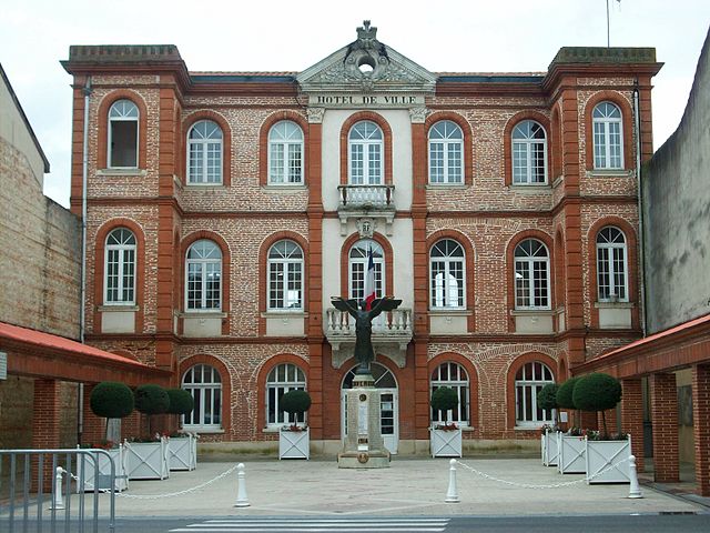
Cintegabelle (Cintegabelle)
- commune in Haute-Garonne, France
- Country:

- Postal Code: 31550
- Coordinates: 43° 18' 46" N, 1° 31' 50" E


- GPS tracks (wikiloc): [Link]
- Area: 52.92 sq km
- Population: 2875
- Web site: http://www.mairie-cintegabelle.fr
- Wikipedia en: wiki(en)
- Wikipedia: wiki(fr)
- Wikidata storage: Wikidata: Q1152930
- Wikipedia Commons Category: [Link]
- Freebase ID: [/m/03nsy_n]
- Freebase ID: [/m/03nsy_n]
- GeoNames ID: Alt: [3024932]
- GeoNames ID: Alt: [3024932]
- SIREN number: [213101454]
- SIREN number: [213101454]
- BnF ID: [152551419]
- BnF ID: [152551419]
- VIAF ID: Alt: [139901597]
- VIAF ID: Alt: [139901597]
- Library of Congress authority ID: Alt: [no2003129786]
- Library of Congress authority ID: Alt: [no2003129786]
- PACTOLS thesaurus ID: [pcrt0TXfSt2nWX]
- PACTOLS thesaurus ID: [pcrt0TXfSt2nWX]
- MusicBrainz area ID: [5fc01359-fbb8-461c-b2c6-315bd51c0150]
- MusicBrainz area ID: [5fc01359-fbb8-461c-b2c6-315bd51c0150]
- INSEE municipality code: 31145
- INSEE municipality code: 31145
Shares border with regions:
Canté
- commune in Ariège, France
- Country:

- Postal Code: 09700
- Coordinates: 43° 15' 17" N, 1° 31' 54" E


- GPS tracks (wikiloc): [Link]
- Area: 9.8 sq km
- Population: 207
Labatut
- commune in Ariège, France
- Country:

- Postal Code: 09700
- Coordinates: 43° 15' 41" N, 1° 31' 0" E


- GPS tracks (wikiloc): [Link]
- Area: 3.58 sq km
- Population: 172
Lissac
- commune in Ariège, France
- Country:

- Postal Code: 09700
- Coordinates: 43° 16' 9" N, 1° 30' 41" E


- GPS tracks (wikiloc): [Link]
- Area: 3.77 sq km
- Population: 234


Calmont
- commune in Haute-Garonne, France
- Country:

- Postal Code: 31560
- Coordinates: 43° 17' 12" N, 1° 38' 3" E


- GPS tracks (wikiloc): [Link]
- Area: 40.27 sq km
- Population: 2388
- Web site: [Link]
Saint-Quirc
- commune in Ariège, France
- Country:

- Postal Code: 09700
- Coordinates: 43° 16' 33" N, 1° 30' 9" E


- GPS tracks (wikiloc): [Link]
- Area: 3.75 sq km
- Population: 382


Mauvaisin
- commune in Haute-Garonne, France
- Country:

- Postal Code: 31190
- Coordinates: 43° 21' 17" N, 1° 32' 59" E


- GPS tracks (wikiloc): [Link]
- Area: 11.05 sq km
- Population: 239

Gaillac-Toulza
- commune in Haute-Garonne, France
- Country:

- Postal Code: 31550
- Coordinates: 43° 15' 17" N, 1° 28' 15" E


- GPS tracks (wikiloc): [Link]
- Area: 40.4 sq km
- Population: 1245
- Web site: [Link]


Auterive
- commune in Haute-Garonne, France
- Country:

- Postal Code: 31190
- Coordinates: 43° 21' 1" N, 1° 28' 29" E


- GPS tracks (wikiloc): [Link]
- AboveSeaLevel: 185 м m
- Area: 36.54 sq km
- Population: 9417
- Web site: [Link]


Caujac
- commune in Haute-Garonne, France
- Country:

- Postal Code: 31190
- Coordinates: 43° 17' 56" N, 1° 28' 5" E


- GPS tracks (wikiloc): [Link]
- Area: 10.82 sq km
- Population: 833
- Web site: [Link]

Saverdun
- commune in Ariège, France
- Country:

- Postal Code: 09700
- Coordinates: 43° 14' 4" N, 1° 34' 28" E


- GPS tracks (wikiloc): [Link]
- AboveSeaLevel: 235 м m
- Area: 61.47 sq km
- Population: 4734
- Web site: [Link]


Aignes
- commune in Haute-Garonne, France
- Country:

- Postal Code: 31550
- Coordinates: 43° 19' 13" N, 1° 35' 19" E


- GPS tracks (wikiloc): [Link]
- Area: 21.81 sq km
- Population: 249
