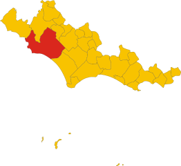
Cisterna di Latina (Cisterna di Latina)
.svg)
- Italian comune
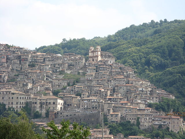
 Hiking in Cisterna di Latina
Cisterna di Latina, located in the Lazio region of Italy, offers a unique setting for hiking enthusiasts. This area is characterized by its picturesque landscapes, rolling hills, and proximity to both the Tyrrhenian Sea and the Apennine Mountains. If you're considering hiking in this area, here are some key points to consider:
Trails and Natural Areas
-
Local Parks and Nature Reserves: The nearby Parco Nazionale del Circeo and Parco Regionale dei Castelli Romani provide numerous hiking trails amidst diverse flora and fauna. These parks often feature trails that range from easy walks to more challenging hikes.
-
Historical Trails: The region is rich in history, and some trails may lead you to ancient ruins, medieval castles, and historical towns. Exploring these sites can add a cultural dimension to your hiking experience.
-
Countryside Hiking: The surrounding countryside offers scenic routes through vineyards, olive groves, and farmland, making for enjoyable hikes with beautiful views.
Best Time to Hike
- Spring (March to May): Ideal for hiking with mild temperatures and blooming wildflowers.
- Fall (September to November): Another great time as the weather is still pleasant, and you can enjoy the autumn colors.
Tips for Hiking in Cisterna di Latina
- Prepare for Varying Conditions: Weather can change quickly, so be prepared with layered clothing and rain gear.
- Stay Hydrated: Bring enough water, especially if hiking in hotter months.
- Respect Nature: Follow Leave No Trace principles; stick to marked trails and avoid disturbing wildlife.
- Local Guides: If you're unfamiliar with the area, consider hiring a local guide to enhance your experience and navigate the trails safely.
Getting There
Cisterna di Latina is accessible by car and public transport from Rome and other nearby cities. The area has good connections for reaching starting points of various trails.
Whether you're a beginner looking for a leisurely walk or an experienced hiker seeking a challenge, Cisterna di Latina and its surroundings offer diverse options for enjoying the beauty of Italy's landscapes.
- Country:

- Postal Code: 04012
- Local Dialing Code: 06
- Licence Plate Code: LT
- Coordinates: 41° 36' 0" N, 12° 50' 0" E


- GPS tracks (wikiloc): [Link]
- AboveSeaLevel: 77 м m
- Area: 144.16 sq km
- Population: 36980
- Web site: http://www.comune.cisterna.latina.it
- Wikipedia en: wiki(en)
- Wikipedia: wiki(it)
- Wikidata storage: Wikidata: Q128065
- Wikipedia Commons Category: [Link]
- Freebase ID: [/m/01ck4h]
- GeoNames ID: Alt: [6541617]
- VIAF ID: Alt: [158502098]
- OSM relation ID: [68912]
- UN/LOCODE: [ITCIS]
- Gran Enciclopèdia Catalana ID: [0017894]
- ISTAT ID: 059005
- Italian cadastre code: C740
Shares border with regions:


Aprilia, Lazio
- Italian comune
Hiking in Aprilia, Lazio
Aprilia, located in the Lazio region of Italy, offers some enjoyable hiking opportunities for outdoor enthusiasts looking to explore the scenic landscapes and historical sites in the area. Here are some highlights and tips for hiking around Aprilia:...
- Country:
- Postal Code: 04011
- Local Dialing Code: 06
- Licence Plate Code: LT
- Coordinates: 41° 35' 0" N, 12° 39' 0" E
- GPS tracks (wikiloc): [Link]
- AboveSeaLevel: 80 м m
- Area: 178.11 sq km
- Population: 74190
- Web site: [Link]


Cori
- Italian comune
Hiking in Cori
Cori, located in the region of Lazio, is known for its picturesque landscapes, rich history, and charming medieval architecture. Hiking in this area offers a blend of natural beauty and cultural exploration, making it a rewarding experience....
- Country:
- Postal Code: 04010
- Local Dialing Code: 06
- Licence Plate Code: LT
- Coordinates: 41° 39' 0" N, 12° 55' 0" E
- GPS tracks (wikiloc): [Link]
- AboveSeaLevel: 384 м m
- Area: 85.31 sq km
- Population: 10893
- Web site: [Link]


Norma
- Italian comune
Hiking in Norma
Norma, a charming town in the Lazio region of Italy, offers beautiful hiking opportunities with its stunning landscapes, historical sites, and proximity to the Monti Lepini mountains. Here are some highlights for hiking in and around Norma:...
- Country:
- Postal Code: 04010
- Local Dialing Code: 0773
- Licence Plate Code: LT
- Coordinates: 41° 35' 0" N, 12° 58' 0" E
- GPS tracks (wikiloc): [Link]
- AboveSeaLevel: 410 м m
- Area: 31.22 sq km
- Population: 4046
- Web site: [Link]


Sermoneta
- Italian comune
Hiking in Sermoneta
Sermoneta is a charming medieval town located in the province of Latina in the Lazio region of Italy. It is surrounded by beautiful natural landscapes, making it an excellent destination for hiking enthusiasts. Here are some key highlights and tips for hiking in and around Sermoneta:...
- Country:
- Postal Code: 04013
- Local Dialing Code: 0773
- Licence Plate Code: LT
- Coordinates: 41° 33' 0" N, 12° 59' 0" E
- GPS tracks (wikiloc): [Link]
- AboveSeaLevel: 257 м m
- Area: 45 sq km
- Population: 10077
- Web site: [Link]

Latina
- Italian comune
Hiking in Latina
Latina is a beautiful province in the Lazio region of Italy, known for its diverse landscapes including mountains, hills, and coastal areas. Here are some key points and popular hiking options in Latina:...
- Country:
- Postal Code: 04010; 04013; 04100
- Local Dialing Code: 0773
- Licence Plate Code: LT
- Coordinates: 41° 28' 3" N, 12° 54' 13" E
- GPS tracks (wikiloc): [Link]
- AboveSeaLevel: 21 м m
- Area: 277.62 sq km
- Population: 126181
- Web site: [Link]


Velletri
- Italian comune
Hiking in Velletri
Velletri, a town located in the Castelli Romani region of Italy, offers a variety of hiking opportunities that showcase the natural beauty and historical significance of the area. Here are some key points about hiking in Velletri:...
- Country:
- Postal Code: 00049
- Local Dialing Code: 06
- Licence Plate Code: ROMA
- Coordinates: 41° 40' 0" N, 12° 47' 0" E
- GPS tracks (wikiloc): [Link]
- AboveSeaLevel: 332 м m
- Area: 113.23 sq km
- Population: 53188
- Web site: [Link]

Artena
- Italian comune
Hiking in Artena
Artena is a charming hilltop town located in the province of Rome, Italy. It is set in the beautiful landscape of the Lazio region, surrounded by hills, forests, and panoramic views, making it a great destination for hiking enthusiasts. Here are a few highlights about hiking in and around Artena:...
- Country:
- Postal Code: 00031
- Local Dialing Code: 06
- Licence Plate Code: RM
- Coordinates: 41° 44' 0" N, 12° 55' 0" E
- GPS tracks (wikiloc): [Link]
- AboveSeaLevel: 420 м m
- Area: 54.8 sq km
- Population: 14107
- Web site: [Link]