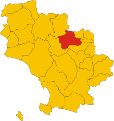
Civitella Paganico (Civitella Paganico)
.svg)
- Italian comune
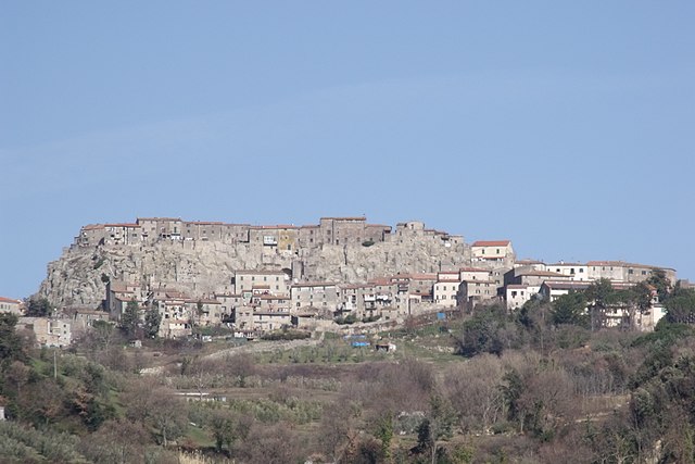
 Hiking in Civitella Paganico
Civitella Paganico, located in the picturesque region of Tuscany, Italy, offers a range of hiking opportunities amidst rolling hills, vineyards, olive groves, and charming medieval villages. This area is characterized by its stunning landscapes and serene environment, making it a great destination for both novice and experienced hikers.
Hiking Trails and Areas
-
Monte Rufeno Nature Reserve: This protected area offers various trails that wind through beautiful forests and offer scenic views of the surrounding countryside. The diverse flora and fauna add to the experience, making it ideal for nature enthusiasts.
-
Countryside Trails: There are numerous trails that connect Civitella Paganico to nearby villages such as Pari and Civitella Marittima. These paths often lead through scenic vineyards and olive groves, providing a chance to enjoy the tranquil landscape of rural Tuscany.
-
The Via Francigena: Parts of the historic pilgrimage route pass through this area. Hiking along the Via Francigena not only offers beautiful views but also a glimpse into the region's history.
-
Custom Routes: Many local hiking clubs and guides offer custom trails that cater to different skill levels. These routes often include stops at historical sites and local eateries to enjoy authentic Tuscan cuisine.
Tips for Hiking in Civitella Paganico
-
Best Time to Hike: The best months for hiking are typically from April to June and September to October when the weather is mild.
-
Gear: Good hiking boots, weather-appropriate clothing, and plenty of water are essential. Depending on the time of year, layering is recommended due to potential temperature changes throughout the day.
-
Local Cuisine: Don’t miss the opportunity to enjoy local foods at agriturismos or during town festivals. Tuscan cuisine is renowned, and local wines like Chianti can be a delightful reward after a day of hiking.
-
Respect Nature: As with any hiking area, it’s crucial to respect the environment. Stick to marked paths and carry out any trash to help preserve the region's beauty.
Conclusion
Whether you’re seeking solitude in nature, a challenging hike with friends, or a cultural experience through the charming towns of Tuscany, Civitella Paganico offers an exciting adventure for all hiking enthusiasts. Enjoy the blend of natural beauty and cultural richness that this area has to offer!
- Country:

- Postal Code: 58045
- Local Dialing Code: 0564
- Licence Plate Code: GR
- Coordinates: 42° 59' 42" N, 11° 16' 54" E


- GPS tracks (wikiloc): [Link]
- AboveSeaLevel: 329 м m
- Area: 192.9 sq km
- Population: 3181
- Web site: http://www.civitella-paganico.it/
- Wikipedia en: wiki(en)
- Wikipedia: wiki(it)
- Wikidata storage: Wikidata: Q188573
- Wikipedia Commons Category: [Link]
- Freebase ID: [/m/0gm1bj]
- GeoNames ID: Alt: [3178567]
- VIAF ID: Alt: [248264932]
- OSM relation ID: [42244]
- GND ID: Alt: [4461433-0]
- UN/LOCODE: [ITLLG]
- ISTAT ID: 053008
- Italian cadastre code: C782
Shares border with regions:


Campagnatico
- Italian comune
Hiking in Campagnatico
Campagnatico is a charming village located in the Tuscan province of Grosseto, Italy. It's nestled in the scenic Maremma region, known for its rolling hills, olive groves, and vineyards. Hiking in and around Campagnatico offers a variety of trails that allow you to experience the natural beauty and rich cultural heritage of the area....
- Country:
- Postal Code: 58042
- Local Dialing Code: 0564
- Licence Plate Code: GR
- Coordinates: 42° 53' 4" N, 11° 16' 17" E
- GPS tracks (wikiloc): [Link]
- AboveSeaLevel: 275 м m
- Area: 162.25 sq km
- Population: 2387
- Web site: [Link]

Cinigiano
- Italian comune
Hiking in Cinigiano
Cinigiano, located in the enchanting province of Grosseto in Tuscany, Italy, offers a wonderful experience for hiking enthusiasts. The area is characterized by its stunning landscapes, rolling hills, vineyards, olive groves, and picturesque medieval villages....
- Country:
- Postal Code: 58044
- Local Dialing Code: 0564
- Licence Plate Code: GR
- Coordinates: 42° 53' 26" N, 11° 23' 33" E
- GPS tracks (wikiloc): [Link]
- AboveSeaLevel: 324 м m
- Area: 161.55 sq km
- Population: 2536
- Web site: [Link]

Roccastrada
- Italian comune
Hiking in Roccastrada
Roccastrada, located in the southern part of the Tuscany region in Italy, is an excellent destination for hiking enthusiasts. The area is characterized by its beautiful landscapes, rolling hills, and rich natural and cultural heritage. Here are some highlights to consider when hiking in Roccastrada:...
- Country:
- Postal Code: 58036
- Local Dialing Code: 0564
- Licence Plate Code: GR
- Coordinates: 43° 0' 35" N, 11° 10' 6" E
- GPS tracks (wikiloc): [Link]
- AboveSeaLevel: 475 м m
- Area: 284.47 sq km
- Population: 9074
- Web site: [Link]


Montalcino
- Italian comune
Hiking in Montalcino
Montalcino, located in the stunning Tuscany region of Italy, is not only known for its world-famous Brunello wine but also for its beautiful hiking trails that wind through picturesque landscapes, vineyards, and historical sites. Here’s what you need to know about hiking in the Montalcino area:...
- Country:
- Postal Code: 53028; 53024
- Local Dialing Code: 0577
- Licence Plate Code: SI
- Coordinates: 43° 3' 33" N, 11° 29' 21" E
- GPS tracks (wikiloc): [Link]
- AboveSeaLevel: 567 м m
- Area: 310.31 sq km
- Population: 5919
- Web site: [Link]


Monticiano
- Italian comune
Hiking in Monticiano
Monticiano, a charming commune in the province of Siena, Tuscany, offers beautiful hiking opportunities amid stunning landscapes, historical sights, and diverse ecosystems. Here’s what you need to know about hiking in this region:...
- Country:
- Postal Code: 53015
- Local Dialing Code: 0577
- Licence Plate Code: SI
- Coordinates: 43° 8' 0" N, 11° 11' 0" E
- GPS tracks (wikiloc): [Link]
- AboveSeaLevel: 375 м m
- Area: 109.5 sq km
- Population: 1543
- Web site: [Link]


Murlo
- Italian comune
Hiking in Murlo
Murlo is a small town located in the Tuscany region of Italy, known for its beautiful landscapes, rich history, and picturesque views. Hiking in and around Murlo offers a unique experience, with a mix of scenic trails, olive groves, vineyards, and ancient ruins....
- Country:
- Postal Code: 53016
- Local Dialing Code: 0577
- Licence Plate Code: SI
- Coordinates: 43° 10' 16" N, 11° 23' 32" E
- GPS tracks (wikiloc): [Link]
- AboveSeaLevel: 294 м m
- Area: 114.61 sq km
- Population: 2449
- Web site: [Link]