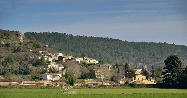
Cléon-d'Andran (Cléon-d'Andran)

- commune in Drôme, France
 Hiking in Cléon-d'Andran
Cléon-d'Andran is a charming commune located in the Drôme department of southeastern France. The surrounding area is characterized by its beautiful landscapes, which are perfect for hiking enthusiasts. Here are some highlights and tips for hiking in and around Cléon-d'Andran:
Scenic Trails
- Local Trails: There are several marked hiking trails ranging in difficulty, allowing hikers to explore the diverse terrain, from wooded areas to open fields with panoramic views.
- Vineyards and Countryside: The trails often pass through local vineyards, offering a unique experience to enjoy the picturesque landscapes and perhaps even indulge in some local wine afterward.
Nature and Wildlife
- The region is home to diverse flora and fauna, making it a great spot for nature lovers. Look out for local wildlife and enjoy the natural beauty, especially in spring and autumn when colors are vibrant.
Points of Interest
- Historical Sites: While hiking, you may come across historical ruins and landmarks that tell the story of the region.
- Cultural Experience: Consider planning your hike to coincide with local markets or festivals for a more immersive cultural experience.
Practical Tips
- Maps and Guides: It’s wise to bring a detailed map or a hiking app to navigate the trails. Local tourist information centers can provide resources.
- Weather Considerations: Check the weather before your hike. The Drôme region can experience sudden weather changes, so be prepared with appropriate clothing and gear.
- Hydration and Snacks: Always carry enough water and snacks to keep your energy up during your hike.
Accessibility
- Cléon-d'Andran is well connected by road, making it accessible for day trips from nearby towns.
Conclusion
Hiking in Cléon-d'Andran offers a wonderful blend of natural beauty, cultural heritage, and physical activity. Whether you're a beginner or an experienced hiker, you'll find trails that cater to your interest and skill level. Enjoy your outdoor adventure!
- Country:

- Postal Code: 26450
- Coordinates: 44° 36' 40" N, 4° 56' 9" E


- GPS tracks (wikiloc): [Link]
- Area: 10.25 sq km
- Population: 856
- Wikipedia en: wiki(en)
- Wikipedia: wiki(fr)
- Wikidata storage: Wikidata: Q860117
- Wikipedia Commons Category: [Link]
- Freebase ID: [/m/03mhfy1]
- Freebase ID: [/m/03mhfy1]
- GeoNames ID: Alt: [6447922]
- GeoNames ID: Alt: [6447922]
- SIREN number: [212600951]
- SIREN number: [212600951]
- BnF ID: [15252956t]
- BnF ID: [15252956t]
- VIAF ID: Alt: [246952110]
- VIAF ID: Alt: [246952110]
- INSEE municipality code: 26095
- INSEE municipality code: 26095
Shares border with regions:


Roynac
- commune in Drôme, France
Hiking in Roynac
Roynac is a charming commune in the Drôme department of southeastern France, located in the Auvergne-Rhône-Alpes region. It offers various hiking opportunities, set against the backdrop of picturesque landscapes, rolling hills, and lush forests. Here are some highlights about hiking in and around Roynac:...
- Country:
- Postal Code: 26450
- Coordinates: 44° 38' 34" N, 4° 56' 23" E
- GPS tracks (wikiloc): [Link]
- Area: 17.06 sq km
- Population: 482

Puy-Saint-Martin
- commune in Drôme, France
Hiking in Puy-Saint-Martin
Puy-Saint-Martin is a picturesque village located in the Drôme department in southeastern France. It sits in a beautiful region characterized by rolling hills, vineyards, and charming countryside. While it may not be as widely known as some other hiking destinations in France, it offers several opportunities for outdoor activities, including hiking....
- Country:
- Postal Code: 26450
- Coordinates: 44° 37' 42" N, 4° 58' 24" E
- GPS tracks (wikiloc): [Link]
- Area: 11.65 sq km
- Population: 872


La Bégude-de-Mazenc
- commune in Drôme, France
Hiking in La Bégude-de-Mazenc
La Bégude-de-Mazenc is a charming village located in the Drôme department in southeastern France, offering a variety of hiking opportunities amidst beautiful natural scenery. The area is characterized by its picturesque landscapes, valleys, and hills, making it an ideal destination for outdoor enthusiasts....
- Country:
- Postal Code: 26160
- Coordinates: 44° 32' 39" N, 4° 56' 9" E
- GPS tracks (wikiloc): [Link]
- Area: 23.62 sq km
- Population: 1684


Saint-Gervais-sur-Roubion
- commune in Drôme, France
Hiking in Saint-Gervais-sur-Roubion
Saint-Gervais-sur-Roubion is a charming commune located in the Drôme department of southeastern France. It’s surrounded by beautiful countryside, making it a great destination for hiking enthusiasts. Here are some highlights and tips for hiking in the area:...
- Country:
- Postal Code: 26160
- Coordinates: 44° 34' 59" N, 4° 53' 27" E
- GPS tracks (wikiloc): [Link]
- Area: 14.57 sq km
- Population: 965


Marsanne
- commune in Drôme, France
Hiking in Marsanne
Marsanne, located in the Drôme department of the Auvergne-Rhône-Alpes region in southeastern France, is surrounded by beautiful landscapes that make it a great destination for hiking enthusiasts. The area is characterized by rolling hills, vineyards, and picturesque countryside, making it ideal for exploring nature....
- Country:
- Postal Code: 26740
- Coordinates: 44° 38' 37" N, 4° 52' 23" E
- GPS tracks (wikiloc): [Link]
- Area: 34.29 sq km
- Population: 1320

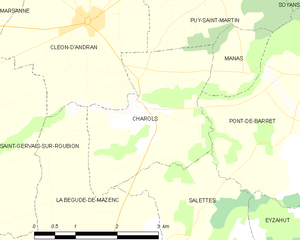
Charols
- commune in Drôme, France
Hiking in Charols
Charols is a charming village located in the Drôme department of the Auvergne-Rhône-Alpes region in southeastern France. It's a great base for hiking enthusiasts due to its picturesque landscapes, diverse terrain, and several trails that cater to various skill levels....
- Country:
- Postal Code: 26450
- Coordinates: 44° 35' 34" N, 4° 57' 5" E
- GPS tracks (wikiloc): [Link]
- Area: 7.31 sq km
- Population: 887