Clérieux (Clérieux)

- commune in Drôme, France
 Hiking in Clérieux
Clérieux is a charming commune located in the Drôme region of southeastern France. It offers a variety of hiking opportunities for outdoor enthusiasts looking to explore the beautiful natural landscape of the area. Here are some details about hiking in Clérieux:
Scenic Trails
-
Varied Terrain: The area around Clérieux features a mix of rolling hills, forests, and rural landscapes, providing a diverse hiking experience.
-
Panoramic Views: Many trails offer stunning views of the surrounding countryside, with opportunities to see vineyards, fields, and even the distant mountains.
-
Well-Marked Paths: Trails in the region are typically well-marked, making it easier for hikers to navigate without getting lost.
Popular Routes
-
Local Loops: There are several loops of varying lengths, perfect for both casual hikers and more experienced trekkers. These routes can often be completed in a few hours.
-
Nature Reserves: Some trails might lead you through protected areas where you can experience local flora and fauna.
-
Cultural Heritage: Along the way, you may encounter historical sites, such as old farms or churches, adding a cultural aspect to your hike.
Tips for Hiking in Clérieux
- Weather Preparedness: The weather can change quickly in the region, so it’s advisable to check the forecast and be prepared for various conditions.
- Proper Gear: Wear sturdy hiking boots and carry enough water and snacks, especially if you plan on taking on more challenging routes.
- Respect Nature: Follow Leave No Trace principles to preserve the natural beauty of the area.
- Local Guidance: If you are new to the area, consider joining a local hiking group or hiring a guide to ensure you experience the best routes safely.
Additional Information
- Accessibility: Check access routes to the starting points of popular trails; some may require a short drive from Clérieux but offer excellent hiking options.
- Community Events: Look for local hiking events or workshops that might help you connect with other hikers or enhance your skills.
Overall, hiking in Clérieux provides a wonderful opportunity to enjoy the beauty of nature while experiencing the charm of the Drôme region. Whether you’re looking for a quick day hike or a longer trek, you’ll find something to suit your interests.
- Country:

- Postal Code: 26260
- Coordinates: 45° 4' 41" N, 4° 57' 34" E


- GPS tracks (wikiloc): [Link]
- Area: 13.53 sq km
- Population: 2021
- Web site: http://www.clerieux.fr
- Wikipedia en: wiki(en)
- Wikipedia: wiki(fr)
- Wikidata storage: Wikidata: Q859605
- Wikipedia Commons Category: [Link]
- Freebase ID: [/m/03mhfyd]
- GeoNames ID: Alt: [6447923]
- SIREN number: [212600969]
- BnF ID: [152529575]
- VIAF ID: Alt: [243572807]
- PACTOLS thesaurus ID: [pcrtblk0Gl1HTs]
- INSEE municipality code: 26096
Shares border with regions:


Saint-Donat-sur-l'Herbasse
- commune in Drôme, France
Hiking in Saint-Donat-sur-l'Herbasse
Saint-Donat-sur-l'Herbasse is a charming commune located in the Drôme department in the Auvergne-Rhône-Alpes region of southeastern France. While it may not be as famous as some of the larger hiking destinations, it offers beautiful landscapes and a variety of trails suitable for hikers of all levels....
- Country:
- Postal Code: 26260
- Coordinates: 45° 7' 23" N, 4° 58' 58" E
- GPS tracks (wikiloc): [Link]
- Area: 19.52 sq km
- Population: 4018

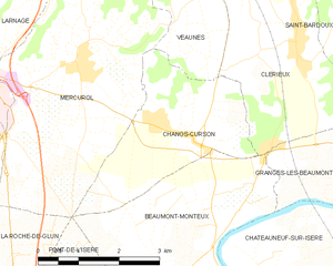
Chanos-Curson
- commune in Drôme, France
Hiking in Chanos-Curson
Chanos-Curson, located in the Drôme department of France, is a charming village that offers an array of hiking opportunities suitable for various skill levels. The picturesque landscapes of the surrounding countryside, including vineyards, hills, and forests, provide a beautiful backdrop for outdoor activities....
- Country:
- Postal Code: 26600
- Coordinates: 45° 3' 43" N, 4° 54' 49" E
- GPS tracks (wikiloc): [Link]
- Area: 8.18 sq km
- Population: 1071
- Web site: [Link]

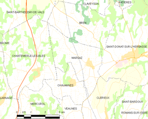
Marsaz
- commune in Drôme, France
Hiking in Marsaz
It seems there might be a misunderstanding regarding "Marsaz." If you meant "Marsa," a region in Malta, or if you are referring to a different location that sounds similar, please clarify....
- Country:
- Postal Code: 26260
- Coordinates: 45° 7' 2" N, 4° 56' 36" E
- GPS tracks (wikiloc): [Link]
- AboveSeaLevel: 281 м m
- Area: 8.95 sq km
- Population: 784


Saint-Bardoux
- commune in Drôme, France
Hiking in Saint-Bardoux
Saint-Bardoux, located in the Rhône-Alpes region of France, offers a variety of hiking opportunities for both beginners and experienced hikers. Here are some key points to consider when hiking in this picturesque area:...
- Country:
- Postal Code: 26260
- Coordinates: 45° 5' 8" N, 4° 58' 22" E
- GPS tracks (wikiloc): [Link]
- Area: 10.63 sq km
- Population: 600


Granges-les-Beaumont
- commune in Drôme, France
Hiking in Granges-les-Beaumont
Granges-les-Beaumont is a charming village located in the Auvergne-Rhône-Alpes region of France, known for its picturesque landscapes and outdoor activities, including hiking. Here are some key points to consider if you’re planning a hiking trip in this area:...
- Country:
- Postal Code: 26600
- Coordinates: 45° 3' 4" N, 4° 58' 59" E
- GPS tracks (wikiloc): [Link]
- AboveSeaLevel: 120 м m
- Area: 7.51 sq km
- Population: 943

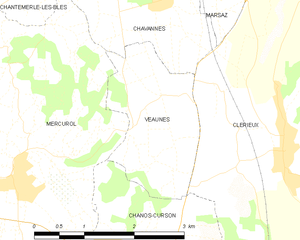
Veaunes
- former commune in Drôme, France
Hiking in Veaunes
Veaunes is a charming little village situated in the picturesque region of the Isère department in the Auvergne-Rhône-Alpes region of southeastern France. Nestled in the foothills of the Alps, it offers stunning views and a variety of hiking opportunities....
- Country:
- Postal Code: 26600
- Coordinates: 45° 5' 2" N, 4° 55' 11" E
- GPS tracks (wikiloc): [Link]
- Area: 4.19 sq km
- Population: 309


Beaumont-Monteux
- commune in Drôme, France
Hiking in Beaumont-Monteux
Beaumont-Monteux, located in the Drôme department of southeastern France, is a charming area that offers a variety of hiking opportunities amidst beautiful landscapes. The region is known for its stunning views of the surrounding mountains, vineyards, and the Rhône River....
- Country:
- Postal Code: 26600
- Coordinates: 45° 1' 12" N, 4° 55' 14" E
- GPS tracks (wikiloc): [Link]
- Area: 13.37 sq km
- Population: 1282


Chavannes
- commune in Drôme, France
Hiking in Chavannes
Chavannes in the Drôme region of France is a scenic area that offers a variety of hiking opportunities amidst stunning natural landscapes. Nestled in the foothills of the Alps and surrounded by beautiful countryside, it is ideal for both novice and experienced hikers....
- Country:
- Postal Code: 26260
- Coordinates: 45° 6' 19" N, 4° 55' 38" E
- GPS tracks (wikiloc): [Link]
- Area: 4.67 sq km
- Population: 672