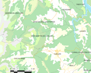
Clelles (Clelles)

- commune in Isère, France
 Hiking in Clelles
Clelles is a charming village located in the French Alps, particularly known for its stunning landscapes and outdoor activities, making it a great spot for hiking enthusiasts. The area offers a variety of trails suitable for different skill levels, from leisurely walks to more challenging hikes.
Hiking Highlights in Clelles:
-
Scenic Trails: The trails around Clelles provide breathtaking views of the surrounding mountains, valleys, and natural landscapes. Look out for trails that offer panoramic vistas of the Dévoluy massif and the Vercors region.
-
Lakes and Waterfalls: Many hikes in the area lead to beautiful lakes and waterfalls, perfect for a refreshing break. The serene atmosphere around these bodies of water makes for a great picnic spot.
-
Wildlife Watching: As you hike, you may have the opportunity to spot local wildlife, including various bird species and possibly deer or chamois, especially in the more secluded areas.
-
Local Flora: The region is rich in biodiversity, with numerous wildflower species that bloom during the warmer months. Identifying local plants can enhance your hiking experience.
-
Cultural Hikes: Some trails may also lead you through historical or culturally significant sites, allowing you to experience the heritage of the area along with its natural beauty.
Tips for Hiking in Clelles:
-
Weather Considerations: The weather can change quickly in the Alps, so be prepared for varying conditions. Make sure to check the forecast and pack accordingly.
-
Trail Conditions: Before heading out, check the condition of the trails. Some may be steep or rocky, requiring proper hiking footwear.
-
Hydration and Snacks: Carry enough water and snacks, especially when hiking longer trails. There may not be facilities along the way.
-
Navigation Tools: While many trails are well-marked, it’s a good idea to have a map or GPS device with you to help stay on course.
-
Respect Nature: Follow the Leave No Trace principles to preserve the natural beauty of the area for future hikers.
Whether you’re looking for a short jaunt or a multi-hour trek, Clelles offers a fantastic setting for hiking adventures. Enjoy your time exploring the great outdoors!
- Country:

- Postal Code: 38930
- Coordinates: 44° 49' 38" N, 5° 37' 23" E


- GPS tracks (wikiloc): [Link]
- Area: 20.88 sq km
- Population: 571
- Wikipedia en: wiki(en)
- Wikipedia: wiki(fr)
- Wikidata storage: Wikidata: Q1011535
- Wikipedia Commons Category: [Link]
- Freebase ID: [/m/03g_4vd]
- GeoNames ID: Alt: [6454062]
- SIREN number: [213801137]
- BnF ID: [15257939f]
- INSEE municipality code: 38113
Shares border with regions:


Percy
- commune in Isère, France
Hiking in Percy
Hiking in Percy, Isère, is a wonderful experience for outdoor enthusiasts, as it offers access to breathtaking landscapes and a variety of trails suitable for different skill levels. Located in the Auvergne-Rhône-Alpes region of France, Percy is surrounded by the stunning natural beauty of the Vercors massif and the Chartreuse mountains....
- Country:
- Postal Code: 38930
- Coordinates: 44° 48' 5" N, 5° 38' 59" E
- GPS tracks (wikiloc): [Link]
- Area: 15.93 sq km
- Population: 165
- Web site: [Link]

Saint-Martin-de-Clelles
- commune in Isère, France
Hiking in Saint-Martin-de-Clelles
Saint-Martin-de-Clelles is a small village located in the picturesque region of the French Alps, specifically in the department of Isère. This area is known for its stunning natural beauty, making it a great destination for hiking enthusiasts. Here are some highlights and tips about hiking in and around Saint-Martin-de-Clelles:...
- Country:
- Postal Code: 38930
- Coordinates: 44° 50' 44" N, 5° 37' 18" E
- GPS tracks (wikiloc): [Link]
- Area: 14.72 sq km
- Population: 181
- Web site: [Link]


Chichilianne
- commune in Isère, France
Hiking in Chichilianne
Chichilianne is a charming village located in the Vercors Regional Natural Park in southeastern France, often referred to as the "Gateway to the Vercors." The area is known for its stunning natural landscapes, including rugged mountains, deep valleys, and diverse flora and fauna, making it an excellent destination for hiking enthusiasts....
- Country:
- Postal Code: 38930
- Coordinates: 44° 48' 42" N, 5° 34' 20" E
- GPS tracks (wikiloc): [Link]
- Area: 62.48 sq km
- Population: 284
- Web site: [Link]


Lavars
- commune in Isère, France
Hiking in Lavars
Lavars is a small village located in the Auvergne-Rhône-Alpes region of France, known for its beautiful natural surroundings and potential hiking opportunities. While Lavars itself may not have extensive trails, it serves as a good base for exploring the surrounding areas, particularly the Vercors Regional Natural Park and the Chartreuse Mountains which are within a reasonable distance....
- Country:
- Postal Code: 38710
- Coordinates: 44° 50' 56" N, 5° 40' 21" E
- GPS tracks (wikiloc): [Link]
- Area: 14.8 sq km
- Population: 149