
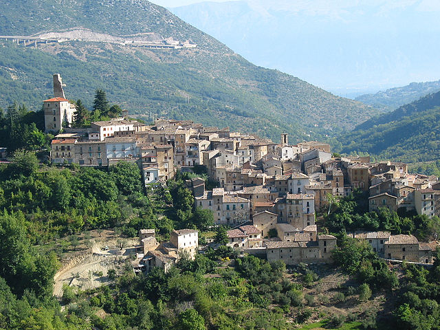
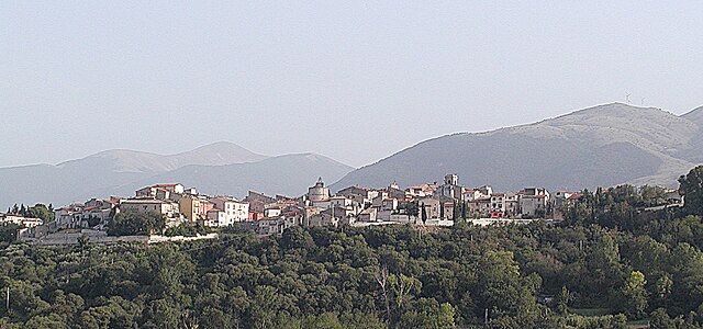
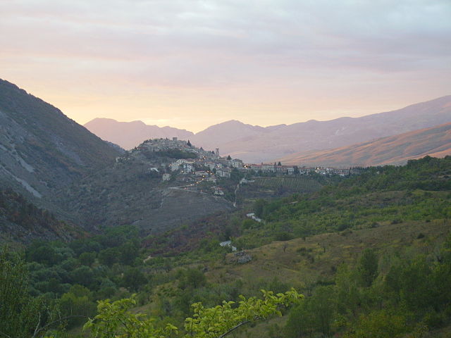
Cocullo (Cocullo)
.svg)
- Italian comune
 Hiking in Cocullo
Cocullo is a charming village located in the Abruzzo region of Italy, specifically within the province of L'Aquila. It's well-known for its beautiful landscapes and hiking opportunities, making it a great destination for outdoor enthusiasts. Here are some highlights of hiking in and around Cocullo:
1. :
Cocullo is surrounded by the stunning Majella National Park and the Sirente-Velino Regional Park, providing access to a variety of hiking trails. These trails can range from easy walks suitable for families to more challenging routes for experienced hikers.
2. :
The area is rich in flora and fauna. As you hike, you may encounter various wildlife, including deer, wolves, and a variety of bird species. The natural beauty includes lush forests, mountain streams, and panoramic views of the Apennine mountains.
3. :
While hiking, you can also explore the local culture and history. Cocullo is famous for its festival, "Festa dei Serpari," where the villagers celebrate the feast of San Domenico by adorning the saint's statue with snakes. This unique tradition reflects the intertwining of the natural world and local customs.
4. :
- Sentiero del Valico: A popular moderate trail offering spectacular views of the surrounding valleys.
- Path to the Pilgrimage Site: A scenic route leading to historical chapels and serene landscapes.
5. :
The best times for hiking in Cocullo are during the spring (April to June) and fall (September to October) when the weather is mild, and the landscape is particularly beautiful.
6. :
Ensure you have appropriate clothing and gear, including durable hiking boots, a water bottle, snacks, a map or GPS device, and sun protection.
7. :
Cocullo offers a selection of local accommodations and eateries where you can enjoy traditional Abruzzese cuisine after your hike.
Always check current trail conditions and weather forecasts before heading out, and consider local regulations regarding hiking and wildlife. Happy hiking in Cocullo!
- Country:

- Postal Code: 67030
- Local Dialing Code: 0864
- Licence Plate Code: AQ
- Coordinates: 42° 2' 2" N, 13° 46' 33" E


- GPS tracks (wikiloc): [Link]
- AboveSeaLevel: 900 м m
- Area: 31.61 sq km
- Population: 219
- Web site: http://www.comune.cocullo.aq.it/
- Wikipedia en: wiki(en)
- Wikipedia: wiki(it)
- Wikidata storage: Wikidata: Q50085
- Wikipedia Commons Category: [Link]
- Freebase ID: [/m/0fg4mh]
- GeoNames ID: Alt: [6541919]
- VIAF ID: Alt: [123361670]
- OSM relation ID: [41732]
- Digital Atlas of the Roman Empire ID: [26579]
- Google Maps Customer ID: [16215757501646832886]
- ISTAT ID: 066037
- Italian cadastre code: C811
Shares border with regions:

Anversa degli Abruzzi
- Italian comune
Hiking in Anversa degli Abruzzi
Anversa degli Abruzzi is a quaint village located in the Abruzzo region of Italy, nestled within the beautiful and rugged landscapes of the Abruzzo National Park. It offers a perfect setting for hiking enthusiasts due to its stunning natural scenery, diverse ecosystems, and various trails that cater to different skill levels....
- Country:
- Postal Code: 67030
- Local Dialing Code: 0864
- Licence Plate Code: AQ
- Coordinates: 41° 59' 41" N, 13° 48' 17" E
- GPS tracks (wikiloc): [Link]
- AboveSeaLevel: 560 м m
- Area: 32.43 sq km
- Population: 317
- Web site: [Link]


Bugnara
- Italian comune
Hiking in Bugnara
Bugnara is a small village located in the province of L'Aquila in the Abruzzo region of Italy, known for its stunning natural landscapes and outdoor activities, including hiking. The area is characterized by beautiful mountains, valleys, and a rich diversity of flora and fauna, making it an attractive destination for nature lovers and hikers....
- Country:
- Postal Code: 67030
- Local Dialing Code: 0864
- Licence Plate Code: AQ
- Coordinates: 42° 1' 29" N, 13° 51' 44" E
- GPS tracks (wikiloc): [Link]
- AboveSeaLevel: 580 м m
- Area: 25.12 sq km
- Population: 1106
- Web site: [Link]


Castel di Ieri
- Italian comune
Hiking in Castel di Ieri
Castel di Ieri is a beautiful and lesser-known destination located in the Province of L'Aquila in the Abruzzo region of Italy. Nestled in the Apennine Mountains, it offers stunning landscapes, rich history, and a variety of hiking opportunities suitable for different skill levels. Here are some key points to consider if you plan to hike in this area:...
- Country:
- Postal Code: 67020
- Local Dialing Code: 0864
- Licence Plate Code: AQ
- Coordinates: 42° 6' 58" N, 13° 44' 37" E
- GPS tracks (wikiloc): [Link]
- AboveSeaLevel: 519 м m
- Area: 18.88 sq km
- Population: 310
- Web site: [Link]

Castelvecchio Subequo
- Italian comune
Hiking in Castelvecchio Subequo
Castelvecchio Subequo is a picturesque village located in the province of L'Aquila, in the Abruzzo region of Italy. It is surrounded by stunning natural landscapes, making it an excellent destination for hiking enthusiasts. Here are some highlights and tips for hiking in and around Castelvecchio Subequo:...
- Country:
- Postal Code: 67024
- Local Dialing Code: 0864
- Licence Plate Code: AQ
- Coordinates: 42° 7' 52" N, 13° 43' 43" E
- GPS tracks (wikiloc): [Link]
- AboveSeaLevel: 490 м m
- Area: 19.29 sq km
- Population: 919
- Web site: [Link]


Goriano Sicoli
- Italian comune
Hiking in Goriano Sicoli
Goriano Sicoli is a charming village located in the province of L'Aquila in the Abruzzo region of Italy, known for its stunning natural beauty and rich cultural heritage. If you're considering hiking in this picturesque area, here are some highlights and tips:...
- Country:
- Postal Code: 67030
- Local Dialing Code: 0864
- Licence Plate Code: AQ
- Coordinates: 42° 4' 54" N, 13° 46' 33" E
- GPS tracks (wikiloc): [Link]
- AboveSeaLevel: 720 м m
- Area: 20.24 sq km
- Population: 528
- Web site: [Link]

Ortona dei Marsi
- Italian comune
Hiking in Ortona dei Marsi
Ortona dei Marsi, located in the Abruzzo region of Italy, is a fantastic destination for hiking enthusiasts. The area boasts beautiful landscapes, rolling hills, and proximity to the stunning Apennine Mountains, offering a variety of trails suitable for different skill levels....
- Country:
- Postal Code: 67050
- Local Dialing Code: 0863
- Licence Plate Code: AQ
- Coordinates: 41° 59' 54" N, 13° 43' 44" E
- GPS tracks (wikiloc): [Link]
- AboveSeaLevel: 1003 м m
- Area: 57.1 sq km
- Population: 496
- Web site: [Link]


Prezza, Abruzzo
- Italian comune
Hiking in Prezza, Abruzzo
Prezza is a charming village located in the Abruzzo region of Italy, surrounded by beautiful landscapes that make it an excellent destination for hiking enthusiasts. Here’s what you need to know about hiking in and around Prezza:...
- Country:
- Postal Code: 67030
- Local Dialing Code: 0864
- Licence Plate Code: AQ
- Coordinates: 42° 3' 37" N, 13° 50' 8" E
- GPS tracks (wikiloc): [Link]
- AboveSeaLevel: 480 м m
- Area: 21.6 sq km
- Population: 940
- Web site: [Link]