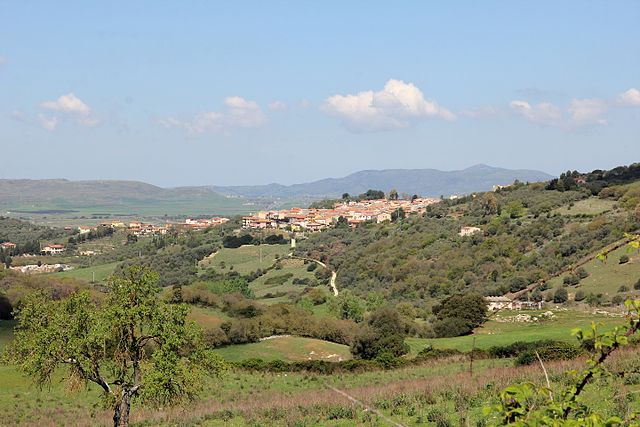
Codrongianos (Codrongianos)
%20-%202016.svg)
- Italian comune
 Hiking in Codrongianos
Codrongianos is a charming village located in the Sardinia region of Italy, known for its beautiful landscapes, rich history, and opportunities for outdoor activities, including hiking. Here are some highlights and tips for hiking in and around Codrongianos:
Scenic Trails
-
Natural Beauty: The surrounding area features stunning landscapes with rolling hills, valleys, and views of the nearby mountains. You can expect to see picturesque vineyards, olive groves, and a variety of flora and fauna.
-
Historical Paths: Many hiking routes in Sardinia link historical sites, such as ancient nuraghi (stone structures), churches, and other archaeological sites. Exploring these paths not only offers great exercise but also a peek into the island's rich culture and history.
-
Local Trails: While there may not be extensive well-marked trails directly in Codrongianos, you can find several local paths and country roads. It’s a good idea to ask locals for recommendations or consult a recent hiking map of the area.
Preparing for Your Hike
-
Gear: Make sure to wear comfortable hiking shoes, attire suitable for variable weather, and carry a backpack with water, snacks, a first-aid kit, and a map or GPS device.
-
Weather Awareness: Check the weather forecast before you head out, as conditions can change quickly in mountainous regions.
-
Respect Nature: Stick to marked trails to protect the environment, and follow Leave No Trace principles by packing out all your trash.
-
Local Insights: Engaging with locals can provide valuable information about the best trails, hidden gems, and tips for navigating the terrain.
Nearby Attractions
-
Alghero: Just a short drive away, you can explore the coastal city of Alghero, famous for its beaches, sea caves, and medieval architecture. There are also coastal trails for a different hiking experience.
-
Sassari: Visit the nearby city of Sassari, where you can enjoy both urban walking and hiking in the surrounding natural areas.
-
Asinara National Park: A bit further afield, this national park offers a unique opportunity to hike in a protected environment with diverse wildlife, including the famous white donkeys.
Local Culture
Don’t miss the opportunity to savor local Sardinian cuisine post-hike. Enjoy traditional dishes such as culurgiones (stuffed pasta), porceddu (roast pig), and the local wines.
Overall
Hiking in and around Codrongianos offers a blend of natural beauty and cultural richness. Whether you’re an experienced hiker or a beginner, there are plenty of opportunities to explore the stunning environment and enjoy the tranquility of Sardinia's landscapes. Always remember to prepare adequately and respect the natural surroundings while you explore!
- Country:

- Postal Code: 07040
- Local Dialing Code: 079
- Licence Plate Code: SS
- Coordinates: 40° 39' 27" N, 8° 40' 53" E


- GPS tracks (wikiloc): [Link]
- AboveSeaLevel: 317 м m
- Area: 30.39 sq km
- Population: 1306
- Web site: http://www.comunecodrongianos.it
- Wikipedia en: wiki(en)
- Wikipedia: wiki(it)
- Wikidata storage: Wikidata: Q390687
- Wikipedia Commons Gallery: [Link]
- Wikipedia Commons Category: [Link]
- Freebase ID: [/m/0gqt2f]
- GeoNames ID: Alt: [6539224]
- VIAF ID: Alt: [241220207]
- OSM relation ID: [40633]
- UN/LOCODE: [ITCS7]
- ISTAT ID: 090026
- Italian cadastre code: C818
Shares border with regions:

Siligo
- Italian comune
Hiking in Siligo
Siligo is a small town located in the province of Sassari in the Sardinia region of Italy. While it may not be widely known as a hiking destination, the surrounding areas of Sardinia offer numerous opportunities for outdoor activities, including hiking....
- Country:
- Postal Code: 07040
- Local Dialing Code: 079
- Licence Plate Code: SS
- Coordinates: 40° 34' 31" N, 8° 43' 39" E
- GPS tracks (wikiloc): [Link]
- AboveSeaLevel: 452 м m
- Area: 43.45 sq km
- Population: 863
- Web site: [Link]


Cargeghe
- Italian comune
Hiking in Cargeghe
Cargeghe is a small town located in the Sardinia region of Italy, known for its beautiful landscapes and outdoor activities, including hiking. The surrounding areas offer a variety of trails that cater to different skill levels, from leisurely walks to more challenging hikes....
- Country:
- Postal Code: 07030
- Local Dialing Code: 079
- Licence Plate Code: SS
- Coordinates: 40° 40' 8" N, 8° 36' 53" E
- GPS tracks (wikiloc): [Link]
- AboveSeaLevel: 333 м m
- Area: 12.05 sq km
- Population: 633
- Web site: [Link]

Florinas
- Italian comune
Hiking in Florinas
Florina, located in the northwestern part of Greece, is an excellent destination for hiking enthusiasts. The region is known for its stunning natural beauty, including mountainous landscapes, dense forests, and diverse flora and fauna. Here are some highlights and considerations for hiking in Florina:...
- Country:
- Postal Code: 07030
- Local Dialing Code: 079
- Licence Plate Code: SS
- Coordinates: 40° 39' 0" N, 8° 40' 0" E
- GPS tracks (wikiloc): [Link]
- AboveSeaLevel: 417 м m
- Area: 36.06 sq km
- Population: 1507
- Web site: [Link]


Osilo
- Italian comune
Hiking in Osilo
Osilo is a small town located in the region of Sardinia, Italy, known for its picturesque landscapes and natural beauty. While it may not be one of the most popular hiking destinations in Sardinia, it offers some wonderful opportunities for outdoor enthusiasts who are looking to explore less crowded trails....
- Country:
- Postal Code: 07033
- Local Dialing Code: 079
- Licence Plate Code: SS
- Coordinates: 40° 44' 37" N, 8° 40' 16" E
- GPS tracks (wikiloc): [Link]
- AboveSeaLevel: 672 м m
- Area: 98.03 sq km
- Population: 3007
- Web site: [Link]


Ploaghe
- Italian comune
Hiking in Ploaghe
Ploaghe is a charming town located in the Sardinia region of Italy. Known for its picturesque landscapes and rich cultural heritage, it offers some unique opportunities for hiking enthusiasts. Here are some details about hiking in and around Ploaghe:...
- Country:
- Postal Code: 07017
- Local Dialing Code: 079
- Licence Plate Code: SS
- Coordinates: 40° 39' 52" N, 8° 44' 43" E
- GPS tracks (wikiloc): [Link]
- AboveSeaLevel: 427 м m
- Area: 96.27 sq km
- Population: 4520
- Web site: [Link]