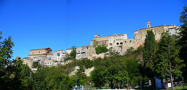
Comunanza (Comunanza)
.svg)
- Italian comune
 Hiking in Comunanza
Comunanza is a charming town located in the Marche region of Italy, surrounded by the stunning natural beauty of the Sibillini Mountains National Park. Hiking in this area offers a great variety of trails and landscapes, making it a fantastic destination for outdoor enthusiasts.
Highlights of Hiking in Comunanza:
-
Diverse Trails: There are several hiking trails that cater to different skill levels, from easy walks suitable for families to more challenging routes for experienced hikers. The trails often take you through forests, meadows, and alongside rivers, showcasing the area’s rich biodiversity.
-
Sibillini Mountains National Park: The park is known for its breathtaking landscapes, including rugged mountains, rolling hills, and beautiful valleys. It is home to various flora and fauna, making it a great spot for nature lovers.
-
Cultural Heritage: While hiking, you may also encounter ancient churches, historic villages, and traditional farms, providing insight into the region's culture and history.
-
Scenic Views: The trails offer stunning panoramic views of the surrounding mountains and valleys. The higher you trek, the more spectacular the vistas, especially from peaks like Monte Sibilla and Monte Vettore.
-
Local Flora and Fauna: Birdwatching and spotting local wildlife—such as deer, wild boar, and various bird species—can be rewarding while on the trails.
-
Accessibility: Comunanza is relatively easy to reach by car or public transport, making it a convenient base for hiking trips.
-
Seasonal Hiking: Each season offers a different experience—spring brings blooming wildflowers, summer features lush greenery, autumn showcases vibrant colors, and winter may offer opportunities for snowshoeing and winter hiking.
Tips for Hiking in Comunanza:
- Weather Considerations: Always check the local weather conditions before heading out, as mountain weather can be unpredictable.
- Proper Gear: Wear suitable hiking boots, layer your clothing, and carry enough water and snacks.
- Maps and Guides: It's beneficial to have a trail map or download a hiking app to navigate the routes effectively.
- Respect Nature: Follow the Leave No Trace principles to preserve the natural environment.
Whether you're looking for a leisurely hike or an adventurous trek, the trails around Comunanza provide a wonderful way to explore the beauty of the Marche region.
- Country:

- Postal Code: 63087
- Local Dialing Code: 0736
- Licence Plate Code: AP
- Coordinates: 42° 57' 26" N, 13° 24' 52" E


- GPS tracks (wikiloc): [Link]
- AboveSeaLevel: 448 м m
- Area: 54.4 sq km
- Population: 3081
- Web site: http://www.comune.comunanza.ap.it
- Wikipedia en: wiki(en)
- Wikipedia: wiki(it)
- Wikidata storage: Wikidata: Q56050
- Wikipedia Commons Category: [Link]
- Freebase ID: [/m/0gl7tl]
- GeoNames ID: Alt: [6538531]
- VIAF ID: Alt: [247851917]
- OSM relation ID: [42218]
- UN/LOCODE: [ITCZ9]
- Google Maps Customer ID: [10352644977859939629]
- ISTAT ID: 044015
- Italian cadastre code: C935
Shares border with regions:

Force, Marche
- Italian comune
Hiking in Force, Marche
Force, located in the Marche region of Italy, is a charming hilltop village surrounded by beautiful landscapes that are perfect for hiking enthusiasts. The area is characterized by its rolling hills, forests, and stunning views of the surrounding countryside, making it an excellent destination for outdoor activities....
- Country:
- Postal Code: 63086
- Local Dialing Code: 0736
- Licence Plate Code: AP
- Coordinates: 42° 57' 48" N, 13° 29' 28" E
- GPS tracks (wikiloc): [Link]
- AboveSeaLevel: 689 м m
- Area: 34.31 sq km
- Population: 1278
- Web site: [Link]
Montegallo
- Italian comune
Hiking in Montegallo
Montegallo is a beautiful destination located in the Apennine Mountains of central Italy, particularly within the province of Ascoli Piceno in the Marche region. It's known for its stunning landscapes, rolling hills, and rich biodiversity, making it a great spot for hiking enthusiasts....
- Country:
- Postal Code: 63094
- Local Dialing Code: 0736
- Licence Plate Code: AP
- Coordinates: 42° 50' 32" N, 13° 19' 58" E
- GPS tracks (wikiloc): [Link]
- AboveSeaLevel: 870 м m
- Area: 48.46 sq km
- Population: 504
- Web site: [Link]

Montemonaco
- Italian comune
Hiking in Montemonaco
Montemonaco is a picturesque village located in the Sibillini Mountains National Park in Italy's Marche region. This area is known for its stunning landscapes, diverse flora and fauna, and rich cultural history. Hiking in and around Montemonaco offers various trails suitable for different skill levels, making it an appealing destination for both novice and experienced hikers....
- Country:
- Postal Code: 63088
- Local Dialing Code: 0736
- Licence Plate Code: AP
- Coordinates: 42° 53' 57" N, 13° 20' 2" E
- GPS tracks (wikiloc): [Link]
- AboveSeaLevel: 980 м m
- Area: 67.81 sq km
- Population: 568
- Web site: [Link]


Palmiano
- comune of Italy
Hiking in Palmiano
Palmiano, located in the Marche region of Italy, is an excellent destination for hiking enthusiasts who appreciate beautiful landscapes, historical sites, and a rich natural environment. While it may not be as well-known as some other hiking destinations in Italy, it offers a variety of trails suitable for different skill levels and plenty of opportunities to explore the area's unique culture and history....
- Country:
- Postal Code: 63092
- Local Dialing Code: 0736
- Licence Plate Code: AP
- Coordinates: 42° 54' 0" N, 13° 27' 31" E
- GPS tracks (wikiloc): [Link]
- AboveSeaLevel: 550 м m
- Area: 12.7 sq km
- Population: 184
- Web site: [Link]
Roccafluvione
- Italian comune
Hiking in Roccafluvione
Roccafluvione is a charming village nestled in the Apennine Mountains in the Marche region of Italy. Known for its picturesque landscapes, rich history, and local culture, it’s a fantastic destination for hikers. Here are some highlights of hiking in and around Roccafluvione:...
- Country:
- Postal Code: 63093
- Local Dialing Code: 0736
- Licence Plate Code: AP
- Coordinates: 42° 50' 52" N, 13° 29' 0" E
- GPS tracks (wikiloc): [Link]
- AboveSeaLevel: 299 м m
- Area: 60.63 sq km
- Population: 1987
- Web site: [Link]


Amandola
- Italian comune
Hiking in Amandola
Amandola is a charming town located in the Marche region of Italy, nestled within the Sibillini Mountains National Park. This area is a fantastic destination for hiking enthusiasts, offering a variety of trails that cater to different skill levels. Here are some key points about hiking in Amandola:...
- Country:
- Postal Code: 63857
- Local Dialing Code: 0736
- Licence Plate Code: FM
- Coordinates: 42° 58' 48" N, 13° 21' 27" E
- GPS tracks (wikiloc): [Link]
- AboveSeaLevel: 550 м m
- Area: 69.5 sq km
- Population: 3569
- Web site: [Link]


Montefortino
- Italian comune
Hiking in Montefortino
Montefortino, located in the Marche region of Italy, is a charming and picturesque destination for hiking enthusiasts. Nestled within the Sibillini Mountains National Park, it offers a diverse range of trails suitable for various skill levels, all surrounded by breathtaking landscapes, rich flora, and fauna....
- Country:
- Postal Code: 63858; 63858 (vecchio codice 63044)
- Local Dialing Code: 0736
- Licence Plate Code: FM
- Coordinates: 42° 56' 34" N, 13° 20' 28" E
- GPS tracks (wikiloc): [Link]
- AboveSeaLevel: 638 м m
- Area: 78.62 sq km
- Population: 1117
- Web site: [Link]


Montefalcone Appennino
- Italian comune
Hiking in Montefalcone Appennino
Montefalcone Appennino is a picturesque village located in the Marche region of Italy, nestled in the Sibillini Mountains. It's known for its stunning landscapes, rich history, and diverse hiking opportunities. Here’s an overview of what you can expect when hiking in this area:...
- Country:
- Postal Code: 63855
- Local Dialing Code: 0734
- Licence Plate Code: FM
- Coordinates: 42° 59' 18" N, 13° 27' 32" E
- GPS tracks (wikiloc): [Link]
- AboveSeaLevel: 757 м m
- Area: 15.99 sq km
- Population: 415
- Web site: [Link]