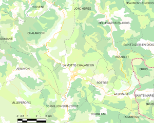
Cornillon-sur-l'Oule (Cornillon-sur-l'Oule)

- commune in Drôme, France
 Hiking in Cornillon-sur-l'Oule
Cornillon-sur-l'Oule is a picturesque village located in the Drôme department in the Auvergne-Rhône-Alpes region of southeastern France. It is surrounded by stunning landscapes, including options for hiking that allow you to experience the natural beauty of the area.
Hiking Trails
-
Sentier de la Clairière: This trail offers a pleasant walk through the forests and is suitable for all levels. You'll encounter diverse flora and fauna, with clearings that provide stunning views of the surrounding hills.
-
Les Gorges de l’Oule: A more challenging hike takes you through the gorges themselves. This route offers dramatic scenery with steep cliffs and the Oule river. It’s a great way to see the rugged terrain of the region.
-
Cultural and Historical Routes: There are paths that take you past historical sites, including old stone structures and remnants of traditional farming methods. These trails often provide insights into the local culture and history.
Preparation Tips
- Weather Awareness: Always check the weather conditions before heading out, as they can change rapidly in mountainous areas.
- Footwear: Wear sturdy hiking boots with good traction, especially if you’re planning on tackling rugged trails.
- Hydration and Snacks: Carry plenty of water and snacks to maintain your energy levels, especially on longer hikes.
- Maps and Navigation: Ensure you have a map or a GPS device, as some trails may not be well-marked.
Wildlife and Scenery
The region is known for its rich biodiversity, including various bird species and wildflowers in the spring. As you hike, keep an eye out for local wildlife and take time to appreciate the panoramic views that offer insights into the landscape of southern France.
Local Amenities
Cornillon-sur-l'Oule has small shops and cafes where you can refuel after your hike. Be sure to try some local delicacies, as regional cuisine is a highlight of any trip to this part of France.
Hiking in Cornillon-sur-l'Oule is not only a way to enjoy the incredible landscapes but also a chance to connect with nature and experience the tranquility of rural France. Whether you are a seasoned hiker or a beginner, there are options for everyone to explore this beautiful area.
- Country:

- Postal Code: 26510
- Coordinates: 44° 27' 31" N, 5° 22' 4" E


- GPS tracks (wikiloc): [Link]
- Area: 14.55 sq km
- Population: 69
- Wikipedia en: wiki(en)
- Wikipedia: wiki(fr)
- Wikidata storage: Wikidata: Q859871
- Wikipedia Commons Category: [Link]
- Freebase ID: [/m/03mhg0v]
- GeoNames ID: Alt: [6430070]
- SIREN number: [212601058]
- BnF ID: [152529664]
- INSEE municipality code: 26105
Shares border with regions:

La Motte-Chalancon
- commune in Drôme, France
Hiking in La Motte-Chalancon
La Motte-Chalancon is a charming village located in the Drôme department in the Auvergne-Rhône-Alpes region of southeastern France. It's a beautiful area for hiking, offering a blend of picturesque landscapes, diverse trails, and a rich natural environment....
- Country:
- Postal Code: 26470
- Coordinates: 44° 29' 7" N, 5° 22' 46" E
- GPS tracks (wikiloc): [Link]
- Area: 22.83 sq km
- Population: 417


Rottier
- commune in Drôme, France
Hiking in Rottier
Rottier, while less commonly known than some other hiking destinations, offers scenic beauty and various trails suitable for hikers of different skill levels. If you're looking to hike in Rottier, here are some key points to consider:...
- Country:
- Postal Code: 26470
- Coordinates: 44° 28' 28" N, 5° 24' 47" E
- GPS tracks (wikiloc): [Link]
- Area: 8.54 sq km
- Population: 22


Saint-May
- commune in Drôme, France
Hiking in Saint-May
Saint-May is a charming area situated in the Auvergne-Rhône-Alpes region of France, near the Vercors Massif, which offers a variety of hiking opportunities. Here are some highlights for hikers in and around Saint-May:...
- Country:
- Postal Code: 26510
- Coordinates: 44° 25' 36" N, 5° 19' 6" E
- GPS tracks (wikiloc): [Link]
- Area: 10.23 sq km
- Population: 41


Villeperdrix
- commune in Drôme, France
Hiking in Villeperdrix
Villeperdrix is a charming village located in the southern part of France, in the Drôme department within the Auvergne-Rhône-Alpes region. Nestled in the foothills of the Vercors mountain range, it offers stunning landscapes and excellent hiking opportunities for outdoor enthusiasts....
- Country:
- Postal Code: 26510
- Coordinates: 44° 26' 31" N, 5° 17' 17" E
- GPS tracks (wikiloc): [Link]
- Area: 26.15 sq km
- Population: 116
- Web site: [Link]


Rémuzat
- commune in Drôme, France
Hiking in Rémuzat
Rémuzat, located in the Drôme department in southeastern France, is a fantastic destination for hiking enthusiasts. Nestled in the stunning landscape of the Vercors Regional Natural Park and the Baronnies Provençales Regional Natural Park, it offers diverse terrains, beautiful vistas, and a mix of challenging trails and gentle hikes for all levels....
- Country:
- Postal Code: 26510
- Coordinates: 44° 24' 49" N, 5° 21' 23" E
- GPS tracks (wikiloc): [Link]
- Area: 16.78 sq km
- Population: 361


Arnayon
- commune in Drôme, France
Hiking in Arnayon
Arnayon is a picturesque village located in the Provence-Alpes-Côte d'Azur region of southeastern France. It's situated on the slopes of the Vercors Massif, offering stunning views and a diverse landscape that makes it a great destination for hiking enthusiasts....
- Country:
- Postal Code: 26470
- Coordinates: 44° 29' 21" N, 5° 19' 4" E
- GPS tracks (wikiloc): [Link]
- Area: 19.45 sq km
- Population: 27


Cornillac
- commune in Drôme, France
Hiking in Cornillac
Cornillac is a lesser-known gem located in the French Alps, making it an ideal destination for hiking enthusiasts seeking scenic views and challenging trails. While not as crowded as some more popular destinations, it offers a variety of hiking opportunities suitable for different skill levels....
- Country:
- Postal Code: 26510
- Coordinates: 44° 26' 35" N, 5° 23' 11" E
- GPS tracks (wikiloc): [Link]
- Area: 19.44 sq km
- Population: 81