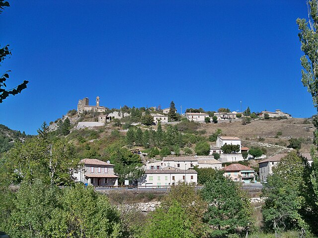
Cornillac (Cornillac)

- commune in Drôme, France
 Hiking in Cornillac
Cornillac is a lesser-known gem located in the French Alps, making it an ideal destination for hiking enthusiasts seeking scenic views and challenging trails. While not as crowded as some more popular destinations, it offers a variety of hiking opportunities suitable for different skill levels.
Hiking Trails:
-
Local Routes: There are many marked trails that vary in difficulty, from easy walks suitable for families to more demanding hikes that will challenge seasoned trekkers.
-
Mountain Passes: The area is characterized by stunning alpine landscapes, including impressive mountain passes and views of the surrounding snow-capped peaks. If you’re looking for a breathtaking panoramic view, aim for summits in the vicinity.
-
Nearby Natural Parks: Cornillac is a great base for exploring nearby national parks where you can find well-maintained trails that lead through forests, past lakes, and along ridges.
Recommended Tips:
- Season Considerations: The best time to hike in Cornillac is typically between late spring and early autumn when trails are clear of snow and weather conditions are more favorable.
- Gear Up: Ensure you have appropriate hiking gear, including sturdy boots, weather-appropriate clothing, and navigation tools or maps.
- Local Wildlife: Be on the lookout for local wildlife, including various bird species and possibly some larger mammals, particularly if you venture into less-trafficked areas.
Accessibility:
- Getting There: Cornillac is accessible by car and is well-connected to larger towns in the region, making it easy to reach starting points for hikes.
- Accommodations: Consider staying in local lodges or campsites if you plan to hike for several days, allowing you to explore more of the area.
Safety:
- Always check weather conditions before heading out, as mountain weather can change rapidly.
- Make sure someone knows your hiking plans and expected return time, particularly if hiking alone.
Enjoy your hike in Cornillac, and take the time to appreciate the stunning natural beauty and tranquil surroundings!
- Country:

- Postal Code: 26510
- Coordinates: 44° 26' 35" N, 5° 23' 11" E


- GPS tracks (wikiloc): [Link]
- Area: 19.44 sq km
- Population: 81
- Wikipedia en: wiki(en)
- Wikipedia: wiki(fr)
- Wikidata storage: Wikidata: Q860031
- Wikipedia Commons Category: [Link]
- Freebase ID: [/m/03m3w87]
- GeoNames ID: Alt: [6430069]
- SIREN number: [212601041]
- BnF ID: [15252965s]
- INSEE municipality code: 26104
Shares border with regions:

Rosans
- commune in Hautes-Alpes, France
Hiking in Rosans
Rosans is a charming village located in the Hautes-Alpes region of southeastern France, known for its picturesque landscapes, diverse flora, and a range of hiking opportunities. Here are some key points about hiking in and around Rosans:...
- Country:
- Postal Code: 05150
- Coordinates: 44° 23' 30" N, 5° 28' 12" E
- GPS tracks (wikiloc): [Link]
- Area: 30.39 sq km
- Population: 492
- Web site: [Link]


Rottier
- commune in Drôme, France
Hiking in Rottier
Rottier, while less commonly known than some other hiking destinations, offers scenic beauty and various trails suitable for hikers of different skill levels. If you're looking to hike in Rottier, here are some key points to consider:...
- Country:
- Postal Code: 26470
- Coordinates: 44° 28' 28" N, 5° 24' 47" E
- GPS tracks (wikiloc): [Link]
- Area: 8.54 sq km
- Population: 22
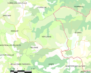
Verclause
- commune in Drôme, France
Hiking in Verclause
Verclause, while not a widely known hiking destination, offers beautiful natural scenery and outdoor activities for hiking enthusiasts. It is likely part of a region that features picturesque landscapes, including perhaps rolling hills, forests, and potentially even rivers or lakes, depending on its geography....
- Country:
- Postal Code: 26510
- Coordinates: 44° 22' 50" N, 5° 25' 40" E
- GPS tracks (wikiloc): [Link]
- Area: 26.14 sq km
- Population: 62


Rémuzat
- commune in Drôme, France
Hiking in Rémuzat
Rémuzat, located in the Drôme department in southeastern France, is a fantastic destination for hiking enthusiasts. Nestled in the stunning landscape of the Vercors Regional Natural Park and the Baronnies Provençales Regional Natural Park, it offers diverse terrains, beautiful vistas, and a mix of challenging trails and gentle hikes for all levels....
- Country:
- Postal Code: 26510
- Coordinates: 44° 24' 49" N, 5° 21' 23" E
- GPS tracks (wikiloc): [Link]
- Area: 16.78 sq km
- Population: 361


Pommerol
- commune in Drôme, France
Hiking in Pommerol
Pommerol, located in the heart of the French Alps, is a charming destination for hiking enthusiasts. The region is known for its stunning landscapes, diverse terrains, and picturesque villages. Here are some highlights and tips for hiking in Pommerol:...
- Country:
- Postal Code: 26470
- Coordinates: 44° 26' 46" N, 5° 27' 8" E
- GPS tracks (wikiloc): [Link]
- AboveSeaLevel: 890 м m
- Area: 9.83 sq km
- Population: 20


Cornillon-sur-l'Oule
- commune in Drôme, France
Hiking in Cornillon-sur-l'Oule
Cornillon-sur-l'Oule is a picturesque village located in the Drôme department in the Auvergne-Rhône-Alpes region of southeastern France. It is surrounded by stunning landscapes, including options for hiking that allow you to experience the natural beauty of the area....
- Country:
- Postal Code: 26510
- Coordinates: 44° 27' 31" N, 5° 22' 4" E
- GPS tracks (wikiloc): [Link]
- Area: 14.55 sq km
- Population: 69
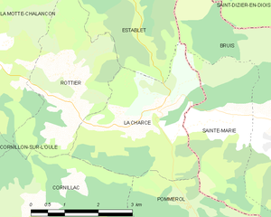
La Charce
- commune in Drôme, France
Hiking in La Charce
La Charce is a beautiful area located in the southern region of the Drôme department in France. It's known for its stunning landscapes, diverse flora and fauna, and serene hiking trails. Here’s some information to help you plan your hiking adventure in La Charce:...
- Country:
- Postal Code: 26470
- Coordinates: 44° 28' 14" N, 5° 27' 3" E
- GPS tracks (wikiloc): [Link]
- Area: 9.43 sq km
- Population: 35