Corps-Nuds (Corps-Nuds)

- commune in Ille-et-Vilaine, France
- Country:

- Postal Code: 35150
- Coordinates: 47° 58' 41" N, 1° 35' 11" E


- GPS tracks (wikiloc): [Link]
- Area: 22.56 sq km
- Population: 3216
- Web site: http://www.corps-nuds.fr
- Wikipedia en: wiki(en)
- Wikipedia: wiki(fr)
- Wikidata storage: Wikidata: Q1011038
- Wikipedia Commons Category: [Link]
- Freebase ID: [/m/03mdx88]
- Freebase ID: [/m/03mdx88]
- GeoNames ID: Alt: [3023545]
- GeoNames ID: Alt: [3023545]
- SIREN number: [213500887]
- SIREN number: [213500887]
- BnF ID: [15257032j]
- BnF ID: [15257032j]
- OSM relation ID: [108433]
- OSM relation ID: [108433]
- INSEE municipality code: 35088
- INSEE municipality code: 35088
Shares border with regions:


Chanteloup
- commune in Ille-et-Vilaine, France
- Country:
- Postal Code: 35150
- Coordinates: 47° 57' 57" N, 1° 36' 56" E
- GPS tracks (wikiloc): [Link]
- Area: 17.53 sq km
- Population: 1845
- Web site: [Link]


Bourgbarré
- commune in Ille-et-Vilaine, France
- Country:
- Postal Code: 35230
- Coordinates: 47° 59' 40" N, 1° 36' 53" E
- GPS tracks (wikiloc): [Link]
- Area: 14.2 sq km
- Population: 3841
- Web site: [Link]


Nouvoitou
- commune in Ille-et-Vilaine, France
- Country:
- Postal Code: 35410
- Coordinates: 48° 2' 26" N, 1° 32' 45" E
- GPS tracks (wikiloc): [Link]
- Area: 18.93 sq km
- Population: 2932
- Web site: [Link]

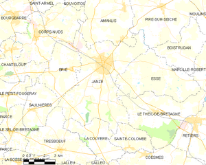
Janzé
- commune in Ille-et-Vilaine, France
- Country:
- Postal Code: 35150
- Coordinates: 47° 57' 38" N, 1° 29' 57" E
- GPS tracks (wikiloc): [Link]
- Area: 41.26 sq km
- Population: 8268


Amanlis
- commune in Ille-et-Vilaine, France
- Country:
- Postal Code: 35150
- Coordinates: 48° 0' 23" N, 1° 28' 34" E
- GPS tracks (wikiloc): [Link]
- Area: 25.25 sq km
- Population: 1688


Brie
- commune in Ille-et-Vilaine, France
- Country:
- Postal Code: 35150
- Coordinates: 47° 57' 7" N, 1° 32' 14" E
- GPS tracks (wikiloc): [Link]
- Area: 13.56 sq km
- Population: 914
- Web site: [Link]

Saint-Armel
- commune in Ille-et-Vilaine, France
- Country:
- Postal Code: 35230
- Coordinates: 48° 0' 42" N, 1° 35' 26" E
- GPS tracks (wikiloc): [Link]
- Area: 7.75 sq km
- Population: 1845
- Web site: [Link]