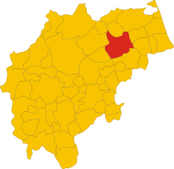
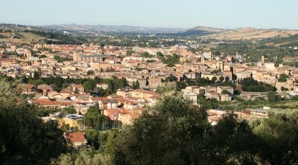
Corridonia (Corridonia)
- Italian comune
 Hiking in Corridonia
Corridonia, located in the Marche region of Italy, is nestled in a beautiful area characterized by rolling hills, scenic vistas, and a rich agricultural landscape. While it might not be as well-known as some of Italy's more famous hiking destinations, it offers a range of hiking opportunities that can be quite rewarding for those looking to explore the region.
Hiking Trails
-
Nature Trails: Corridonia is surrounded by the Sibillini Mountains and the Apennine foothills, providing various trails suitable for different skill levels. You can find well-marked paths that take you through lush countryside, olive groves, and vineyards.
-
Historical Routes: Some trails connect with historical sites, such as ancient churches or old farmstead ruins. Exploring these areas can add a cultural element to your hike.
-
Local Parks: Check for local parks or nature reserves that may have designated hiking routes. Surrounding towns may also offer more extensive trail networks.
Tips for Hiking in Corridonia
- Prepare for Varied Terrain: The trails can vary from flat farmland paths to more rugged hill climbs. Proper footwear is essential.
- Weather Considerations: The best times for hiking are spring (April to June) and early autumn (September to October) when the weather is generally mild.
- Stay Hydrated and Pack Snacks: Bring enough water and some snacks, especially if you plan on taking longer hikes.
- Map and Guide: Consider using a local hiking guidebook or downloading trail maps, as some paths may not always be clearly marked.
- Respect Nature: As in many natural areas, remember to follow Leave No Trace principles to respect the environment.
Nearby Attractions
After hiking, you might want to explore the local culture and cuisine. Corridonia and the surrounding area offer a range of traditional Marche dishes to enjoy. Make sure to visit local farms or osterias to experience the flavors of the region.
Conclusion
While Corridonia may not be a primary hiking destination, it offers a charming mix of nature and culture for those willing to explore. Whether you’re a seasoned hiker or a casual walker, the local trails can provide a delightful way to experience the beauty of this Italian region.
- Country:

- Postal Code: 62014
- Local Dialing Code: 0733
- Licence Plate Code: MC
- Coordinates: 43° 14' 54" N, 13° 30' 27" E


- GPS tracks (wikiloc): [Link]
- AboveSeaLevel: 261 м m
- Area: 61.97 sq km
- Population: 15362
- Web site: http://www.comune.corridonia.mc.it/
- Wikipedia en: wiki(en)
- Wikipedia: wiki(it)
- Wikidata storage: Wikidata: Q73690
- Wikipedia Commons Category: [Link]
- Freebase ID: [/m/0gl6g0]
- GeoNames ID: Alt: [6538519]
- VIAF ID: Alt: [142341962]
- OSM relation ID: [42378]
- GND ID: Alt: [4216647-0]
- Library of Congress authority ID: Alt: [nr95023769]
- WOEID: [714676]
- Quora topic ID: [Corridonia]
- UN/LOCODE: [ITODI]
- ISTAT ID: 043015
- Italian cadastre code: D042
Shares border with regions:

Macerata
- Italian comune
Hiking in Macerata
Macerata is a beautiful area in the Marche region of Italy, known for its stunning landscapes, rich history, and a variety of hiking opportunities. Here are some highlights to consider if you're planning to hike in or around Macerata:...
- Country:
- Postal Code: 62100
- Local Dialing Code: 0733
- Licence Plate Code: MC
- Coordinates: 43° 18' 1" N, 13° 27' 12" E
- GPS tracks (wikiloc): [Link]
- AboveSeaLevel: 315 м m
- Area: 92 sq km
- Population: 42209
- Web site: [Link]


Francavilla d'Ete
- Italian comune
Hiking in Francavilla d'Ete
Francavilla d'Ete is a charming town located in the Marche region of Italy, known for its picturesque landscapes and rich cultural heritage. While it may not be as widely recognized as some other hiking destinations, it offers several opportunities for outdoor enthusiasts to explore the stunning natural beauty of the area....
- Country:
- Postal Code: 63816
- Local Dialing Code: 0734
- Licence Plate Code: FM
- Coordinates: 43° 11' 28" N, 13° 32' 25" E
- GPS tracks (wikiloc): [Link]
- AboveSeaLevel: 224 м m
- Area: 10.2 sq km
- Population: 945
- Web site: [Link]


Monte San Pietrangeli
- Italian comune
Hiking in Monte San Pietrangeli
Monte San Pietrangeli, located in the Marche region of Italy, offers a variety of hiking opportunities that showcase the area's stunning landscapes, rich history, and cultural heritage. The mountain is surrounded by rolling hills, picturesque villages, and lush countryside, making it a great destination for outdoor enthusiasts....
- Country:
- Postal Code: 63815
- Local Dialing Code: 0734
- Licence Plate Code: FM
- Coordinates: 43° 11' 32" N, 13° 34' 43" E
- GPS tracks (wikiloc): [Link]
- AboveSeaLevel: 241 м m
- Area: 18.45 sq km
- Population: 2408
- Web site: [Link]

Mogliano
- Italian commune in the province Macerata
Hiking in Mogliano
Mogliano, located in the Province of Treviso in Italy, is not typically known as a hiking destination compared to more mountainous regions of the country like the Dolomites. However, it does offer some beautiful trails and scenic areas suitable for hiking enthusiasts....
- Country:
- Postal Code: 62010
- Local Dialing Code: 0733
- Licence Plate Code: MC
- Coordinates: 43° 11' 9" N, 13° 28' 51" E
- GPS tracks (wikiloc): [Link]
- AboveSeaLevel: 313 м m
- Area: 29.26 sq km
- Population: 4576
- Web site: [Link]

Monte San Giusto
- Italian comune
Hiking in Monte San Giusto
Monte San Giusto is a charming hilltop town located in the Marche region of Italy, known for its beautiful landscapes, rolling hills, and rich cultural heritage. While it might not be as well-known as some of Italy's larger hiking destinations, it offers several opportunities for hiking enthusiasts....
- Country:
- Postal Code: 62015
- Local Dialing Code: 0733
- Licence Plate Code: MC
- Coordinates: 43° 14' 16" N, 13° 35' 41" E
- GPS tracks (wikiloc): [Link]
- AboveSeaLevel: 236 м m
- Area: 20.04 sq km
- Population: 7984
- Web site: [Link]


Morrovalle
- Italian comune
Hiking in Morrovalle
Morrovalle is a charming town located in the Marche region of Italy, known for its beautiful landscapes and rich history. While it may not be as famous as some larger hiking destinations, it offers a variety of opportunities for outdoor enthusiasts who want to explore its scenic surroundings. Here's what you can expect when hiking in and around Morrovalle:...
- Country:
- Postal Code: 62010
- Local Dialing Code: 0733
- Licence Plate Code: MC
- Coordinates: 43° 18' 53" N, 13° 34' 50" E
- GPS tracks (wikiloc): [Link]
- AboveSeaLevel: 246 м m
- Area: 42.58 sq km
- Population: 10056
- Web site: [Link]


Petriolo
- Italian comune
Hiking in Petriolo
Petriolo is a charming area located in the Tuscany region of Italy, known for its scenic landscapes, thermal springs, and rich history. Hiking in and around Petriolo can be a rewarding experience for those who appreciate nature, culture, and outdoor activities....
- Country:
- Postal Code: 62010
- Local Dialing Code: 0733
- Licence Plate Code: MC
- Coordinates: 43° 13' 17" N, 13° 27' 42" E
- GPS tracks (wikiloc): [Link]
- AboveSeaLevel: 271 м m
- Area: 15.65 sq km
- Population: 1957
- Web site: [Link]

Tolentino
- Italian comune
Hiking in Tolentino
Tolentino is a charming town located in the Marche region of Italy, surrounded by beautiful landscapes and offering various hiking opportunities. Here are some highlights and tips for hiking in and around Tolentino:...
- Country:
- Postal Code: 62029
- Local Dialing Code: 0733
- Licence Plate Code: MC
- Coordinates: 43° 12' 31" N, 13° 17' 3" E
- GPS tracks (wikiloc): [Link]
- AboveSeaLevel: 256 м m
- Area: 95.12 sq km
- Population: 19409
- Web site: [Link]


Urbisaglia
- Italian comune
Hiking in Urbisaglia
Urbisaglia, located in the Marche region of Italy, is an excellent destination for hiking enthusiasts. The area is rich in natural beauty and historical significance, making it a great spot for outdoor activities along with cultural exploration. Here are some highlights for a hiking experience in Urbisaglia:...
- Country:
- Postal Code: 62010
- Local Dialing Code: 0733
- Licence Plate Code: MC
- Coordinates: 43° 11' 50" N, 13° 22' 38" E
- GPS tracks (wikiloc): [Link]
- AboveSeaLevel: 310 м m
- Area: 22.86 sq km
- Population: 2577
- Web site: [Link]