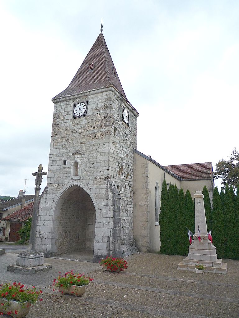
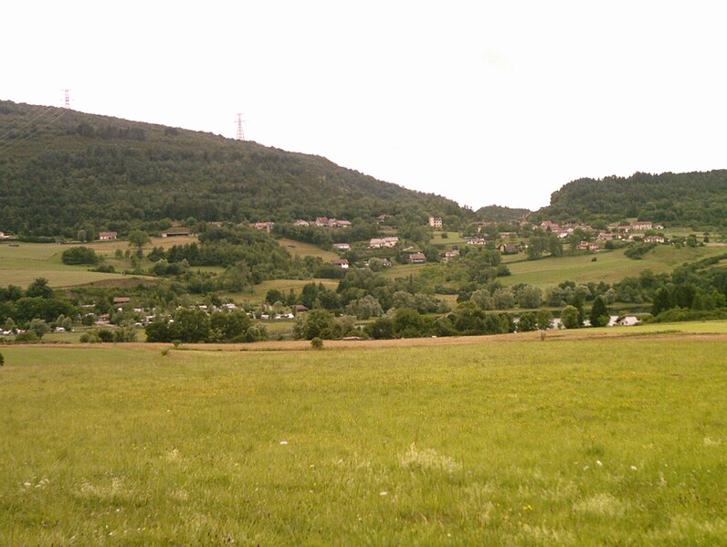
Corveissiat (Corveissiat)
- commune in Ain, France
 Hiking in Corveissiat
Corveissiat is a charming commune located in the Ain department in the Auvergne-Rhône-Alpes region of France. Nestled in the picturesque Jura Mountains, it offers beautiful natural scenery and numerous hiking opportunities for outdoor enthusiasts.
Hiking Highlights in Corveissiat
-
Scenic Trails: The area around Corveissiat features a variety of trails ranging from easy walks to more challenging hikes. Many of these paths offer stunning views of the surrounding mountains, forests, and valleys.
-
Natural Parks: Corveissiat is in proximity to the Haut-Jura Regional Nature Park, where you can explore extensive trails through its diverse landscapes, including alpine meadows, deep forests, and natural lakes.
-
Flora and Fauna: The Jura Mountains are known for their rich biodiversity. As you hike, keep an eye out for many unique plant species, wildlife, and stunning viewpoints that provide opportunities for photography.
-
Local Features: Exploring the local area may lead you to interesting geological formations, charming villages, and cultural sites. Look out for traditional architecture and local history along the trails.
-
Seasonal Hiking: Each season offers a different hiking experience. Spring and summer provide lush greenery and wildflowers, while fall showcases vibrant foliage. Winter can bring snow-covered landscapes, but be sure to check trail conditions and be prepared for winter hiking if you choose to go during this season.
Tips for Hiking in Corveissiat
- Maps and Guides: Make sure to have a hiking map or download trail apps that provide detailed information about the routes and difficulty levels.
- Safety First: Always inform someone about your hiking plans, bring sufficient water, snacks, and appropriate clothing for changing weather conditions.
- Respect Nature: Stay on marked trails to protect the local flora and fauna, and remember to pack out what you pack in.
Local Amenities
Corveissiat has local amenities, including small shops and possibly accommodations for those wanting to extend their stay and explore more of the surrounding area.
Whether you’re looking for a short walk or a full-day hike, Corveissiat's scenic beauty and natural charm provide a perfect backdrop for outdoor activities. Enjoy your hiking adventure!
- Country:

- Postal Code: 01250
- Coordinates: 46° 14' 35" N, 5° 28' 53" E


- GPS tracks (wikiloc): [Link]
- Area: 22.69 sq km
- Population: 622
- Web site: http://corveissiat.fr
- Wikipedia en: wiki(en)
- Wikipedia: wiki(fr)
- Wikidata storage: Wikidata: Q844230
- Wikipedia Commons Category: [Link]
- Wikipedia Commons Maps Category: [Link]
- Freebase ID: [/m/03cz44k]
- Freebase ID: [/m/03cz44k]
- GeoNames ID: Alt: [6424501]
- GeoNames ID: Alt: [6424501]
- SIREN number: [210101259]
- SIREN number: [210101259]
- VIAF ID: Alt: [249421037]
- VIAF ID: Alt: [249421037]
- INSEE municipality code: 01125
- INSEE municipality code: 01125
Shares border with regions:


Thoirette
- former commune in Jura, France
Hiking in Thoirette
Thoirette is a small town located in the Jura region of France, known for its picturesque landscapes and outdoor activities, including hiking. The surrounding Jura mountains offer a variety of trails suitable for different levels of hikers. Here are some highlights and tips for hiking in Thoirette:...
- Country:
- Postal Code: 39240
- Coordinates: 46° 16' 16" N, 5° 31' 57" E
- GPS tracks (wikiloc): [Link]
- Area: 8.77 sq km
- Population: 675

Aromas
- former commune in Jura, France
Hiking in Aromas
Aromas is a small village in the Jura department of France, known for its picturesque landscapes and natural beauty. Hiking in this area offers a range of trails that wind through lush forests, rolling hills, and scenic viewpoints, appealing to both novice and experienced hikers....
- Country:
- Postal Code: 39240
- Coordinates: 46° 17' 33" N, 5° 28' 50" E
- GPS tracks (wikiloc): [Link]
- Area: 18.75 sq km
- Population: 557

Bolozon
- commune in Ain, France
Hiking in Bolozon
Bolozon, located in the Jura region of France, is known for its stunning landscapes and natural beauty, making it an ideal destination for hiking enthusiasts. Here’s what you can expect when hiking in Bolozon:...
- Country:
- Postal Code: 01450
- Coordinates: 46° 11' 34" N, 5° 28' 28" E
- GPS tracks (wikiloc): [Link]
- Area: 4.92 sq km
- Population: 89
Matafelon-Granges
- commune in Ain, France
Hiking in Matafelon-Granges
Matafelon-Granges is a commune in the Ain department in the Auvergne-Rhône-Alpes region of France. Nestled in the beautiful countryside, it offers various hiking opportunities for nature enthusiasts, with picturesque landscapes and charming local scenery....
- Country:
- Postal Code: 01580
- Coordinates: 46° 15' 40" N, 5° 33' 14" E
- GPS tracks (wikiloc): [Link]
- Area: 21.54 sq km
- Population: 647

Chavannes-sur-Suran
- former commune in Ain, France
Hiking in Chavannes-sur-Suran
Chavannes-sur-Suran is a small commune located in the Jura department of France. It's surrounded by beautiful natural landscapes, making it a great destination for hiking enthusiasts. Here are some points of interest for hiking in this area:...
- Country:
- Postal Code: 01250
- Coordinates: 46° 15' 48" N, 5° 25' 36" E
- GPS tracks (wikiloc): [Link]
- Area: 21.5 sq km
- Population: 656

Grand-Corent
- commune in Ain, France
Hiking in Grand-Corent
Grand-Corent, located in the French Alps, is a magnificent destination for hikers, offering stunning landscapes and a variety of trails suitable for different skill levels. Here’s a guide to help you make the most of your hiking experience in this picturesque region:...
- Country:
- Postal Code: 01250
- Coordinates: 46° 11' 57" N, 5° 25' 51" E
- GPS tracks (wikiloc): [Link]
- Area: 7.13 sq km
- Population: 177

Simandre-sur-Suran
- commune in Ain, France
Hiking in Simandre-sur-Suran
Simandre-sur-Suran is a charming commune located in the Ain department of the Auvergne-Rhône-Alpes region in eastern France. While it may not be as well-known for hiking as some other areas, it offers opportunities to explore the beautiful landscapes and natural surroundings typical of rural France....
- Country:
- Postal Code: 01250
- Coordinates: 46° 13' 31" N, 5° 25' 1" E
- GPS tracks (wikiloc): [Link]
- Area: 16.3 sq km
- Population: 683
- Web site: [Link]

Cize
- commune in Ain, France
Hiking in Cize
Cize, located in the Ain department in the Auvergne-Rhône-Alpes region of France, is a fantastic destination for hiking enthusiasts. The area is known for its stunning natural landscapes and diverse terrain, ranging from rolling hills to dense forests and scenic vistas....
- Country:
- Postal Code: 01250
- Coordinates: 46° 12' 15" N, 5° 26' 44" E
- GPS tracks (wikiloc): [Link]
- Area: 4.52 sq km
- Population: 171
- Web site: [Link]

Germagnat
- former commune in Ain, France
Hiking in Germagnat
Germagnat is a beautiful hiking destination that often features scenic trails, picturesque landscapes, and a peaceful environment. While it's not a widely known region in hiking circles, if it encompasses areas in the northern Alps or Jura mountains, you can expect to find a variety of trails suited for different skill levels....
- Country:
- Postal Code: 01250
- Coordinates: 46° 18' 39" N, 5° 26' 55" E
- GPS tracks (wikiloc): [Link]
- Area: 9.48 sq km
- Population: 144