Cottun (Cottun)

- commune in Calvados, France
- Country:

- Postal Code: 14400
- Coordinates: 49° 16' 19" N, 0° 47' 36" E


- GPS tracks (wikiloc): [Link]
- Area: 3.77 sq km
- Population: 209
- Wikipedia en: wiki(en)
- Wikipedia: wiki(fr)
- Wikidata storage: Wikidata: Q214562
- Wikipedia Commons Category: [Link]
- Freebase ID: [/m/02r1c2]
- Freebase ID: [/m/02r1c2]
- GeoNames ID: Alt: [6427163]
- GeoNames ID: Alt: [6427163]
- SIREN number: [211401849]
- SIREN number: [211401849]
- BnF ID: [15247598n]
- BnF ID: [15247598n]
- INSEE municipality code: 14184
- INSEE municipality code: 14184
Shares border with regions:


Cussy
- commune in Calvados, France
- Country:
- Postal Code: 14400
- Coordinates: 49° 17' 2" N, 0° 45' 45" E
- GPS tracks (wikiloc): [Link]
- Area: 2.34 sq km
- Population: 177


Campigny
- commune in Calvados, France
- Country:
- Postal Code: 14490
- Coordinates: 49° 14' 54" N, 0° 48' 1" E
- GPS tracks (wikiloc): [Link]
- Area: 5.61 sq km
- Population: 191

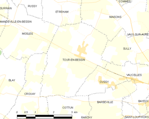
Tour-en-Bessin
- commune in Calvados, France
- Country:
- Postal Code: 14400
- Coordinates: 49° 17' 46" N, 0° 46' 44" E
- GPS tracks (wikiloc): [Link]
- Area: 10.31 sq km
- Population: 638

Barbeville
- commune in Calvados, France
- Country:
- Postal Code: 14400
- Coordinates: 49° 16' 29" N, 0° 44' 57" E
- GPS tracks (wikiloc): [Link]
- Area: 3.47 sq km
- Population: 173


Crouay
- commune in Calvados, France
- Country:
- Postal Code: 14400
- Coordinates: 49° 16' 2" N, 0° 48' 26" E
- GPS tracks (wikiloc): [Link]
- Area: 7.73 sq km
- Population: 532
- Web site: [Link]

Ranchy
- commune in Calvados, France
- Country:
- Postal Code: 14400
- Coordinates: 49° 15' 14" N, 0° 45' 24" E
- GPS tracks (wikiloc): [Link]
- Area: 5.14 sq km
- Population: 235