.JPG)
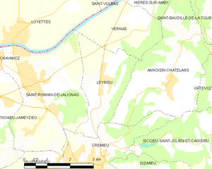
Crémieu (Crémieu)

- commune in Isère, France
 Hiking in Crémieu
Crémieu is a charming medieval town located in the Auvergne-Rhône-Alpes region of France, just northwest of Lyon. It offers a wonderful setting for hikers, combining historical sights with beautiful natural landscapes. Here are some key points about hiking in and around Crémieu:
Trails and Routes
-
Local Hiking Trails: Crémieu is surrounded by several marked trails that allow hikers to explore the area's rolling hills, forests, and vineyards. The trails typically vary in difficulty, making them suitable for different skill levels.
-
Circuit de Crémieu: This is a popular loop trail that offers picturesque views of the town and its surroundings. It provides a chance to experience the rich biodiversity of the region.
-
GR Trails: The Grande Randonnée (GR) trails in the nearby Chartreuse Mountains and Vercors Regional Natural Park offer more challenging hikes, typically requiring a full day or more.
Natural Highlights
-
Historical Sights: While hiking, you can encounter remnants of the town's medieval past, including the well-preserved walls, the Château de Crémieu, and the beautiful old town center.
-
Biodiversity: The area around Crémieu features a mix of agricultural lands and natural habitats, making it a great place for wildlife enthusiasts. Look out for various flora and fauna along the trails.
Preparation Tips
-
Weather Considerations: Be sure to check the weather before heading out, as it can change swiftly in this region. Spring and autumn are particularly beautiful for hiking due to mild temperatures.
-
Footwear: Wear sturdy hiking shoes suitable for both trail and town walking, as some paths may be uneven or rocky.
-
Stay Hydrated: Always carry enough water and snacks, especially for longer hikes. There are limited facilities along some trails.
-
Navigation: Although trails may be marked, carrying a map or using a GPS app is advisable to navigate more complex routes.
Accessibility and Local Services
-
Access: Crémieu is easily accessible by car and is well-connected by public transport from nearby cities. Parking is available in and around the town.
-
Local Amenities: Restaurants, cafés, and grocery stores are available in Crémieu, making it convenient to refuel after a day of hiking.
In summary, Crémieu offers a delightful mix of history and nature, making it a good destination for hikers with varying interests. Whether you're looking for an easy stroll through the historic town or a more challenging hike in the surrounding countryside, you’ll find plenty of options to enjoy the beautiful scenery and rich culture of the area.
- Country:

- Postal Code: 38460
- Coordinates: 45° 43' 29" N, 5° 15' 5" E


- GPS tracks (wikiloc): [Link]
- AboveSeaLevel: 415 м m
- Area: 6.14 sq km
- Population: 3312
- Web site: http://www.ville-cremieu.fr
- Wikipedia en: wiki(en)
- Wikipedia: wiki(fr)
- Wikidata storage: Wikidata: Q460800
- Wikipedia Commons Category: [Link]
- Freebase ID: [/m/03cx2hn]
- GeoNames ID: Alt: [3022600]
- SIREN number: [213801384]
- BnF ID: [15257961m]
- VIAF ID: Alt: [146587040]
- Library of Congress authority ID: Alt: [n81021026]
- WOEID: [587824]
- INSEE municipality code: 38138
Shares border with regions:


Dizimieu
- commune in Isère, France
Hiking in Dizimieu
Dizimieu is a picturesque village located in the Isère department in the Auvergne-Rhône-Alpes region of France. The surrounding area features beautiful natural landscapes, making it a great location for hiking enthusiasts. Here are some key points to know about hiking in and around Dizimieu:...
- Country:
- Postal Code: 38460
- Coordinates: 45° 43' 6" N, 5° 17' 55" E
- GPS tracks (wikiloc): [Link]
- Area: 9.74 sq km
- Population: 836
- Web site: [Link]


Annoisin-Chatelans
- commune in Isère, France
Hiking in Annoisin-Chatelans
Annoisin-Chatelans, located in the Isère department of the Auvergne-Rhône-Alpes region in southeastern France, offers a variety of hiking opportunities for all skill levels. Nestled near the foothills of the French Alps, this area features beautiful landscapes, lush greenery, and scenic views....
- Country:
- Postal Code: 38460
- Coordinates: 45° 45' 25" N, 5° 17' 36" E
- GPS tracks (wikiloc): [Link]
- Area: 13.27 sq km
- Population: 666


Saint-Romain-de-Jalionas
- commune in Isère, France
Hiking in Saint-Romain-de-Jalionas
Saint-Romain-de-Jalionas is a charming commune located in the Auvergne-Rhône-Alpes region of France, specifically within the Isère department. While it may not be as widely known as some other hiking destinations, it offers opportunities for those looking to explore the natural beauty of the area....
- Country:
- Postal Code: 38460
- Coordinates: 45° 45' 11" N, 5° 13' 12" E
- GPS tracks (wikiloc): [Link]
- Area: 13.65 sq km
- Population: 3216

Leyrieu
- commune in Isère, France
Hiking in Leyrieu
Leyrieu is a charming village located in the Auvergne-Rhône-Alpes region of France. Surrounded by beautiful natural landscapes, it offers several opportunities for hiking and outdoor activities. Here are some key points to consider when hiking in Leyrieu:...
- Country:
- Postal Code: 38460
- Coordinates: 45° 45' 28" N, 5° 15' 18" E
- GPS tracks (wikiloc): [Link]
- Area: 6.39 sq km
- Population: 799


Villemoirieu
- commune in Isère, France
Hiking in Villemoirieu
Villemoirieu is a charming commune located in the Isère department of the Auvergne-Rhône-Alpes region in southeastern France. It’s nestled near the foothills of the Alps and offers various hiking opportunities for outdoor enthusiasts. Here’s what you can expect when hiking in and around Villemoirieu:...
- Country:
- Postal Code: 38460
- Coordinates: 45° 42' 57" N, 5° 14' 12" E
- GPS tracks (wikiloc): [Link]
- Area: 13.29 sq km
- Population: 1883
- Web site: [Link]


Siccieu-Saint-Julien-et-Carisieu
- commune in Isère, France
Hiking in Siccieu-Saint-Julien-et-Carisieu
Siccieu-Saint-Julien-et-Carisieu is a picturesque commune located in the Isère department of the Auvergne-Rhône-Alpes region in southeastern France. It is surrounded by beautiful landscapes that offer excellent hiking opportunities. Here are some insights into hiking in this region:...
- Country:
- Postal Code: 38460
- Coordinates: 45° 44' 6" N, 5° 18' 58" E
- GPS tracks (wikiloc): [Link]
- AboveSeaLevel: 335 м m
- Area: 14.22 sq km
- Population: 600