Crachier (Crachier)

- commune in Isère, France
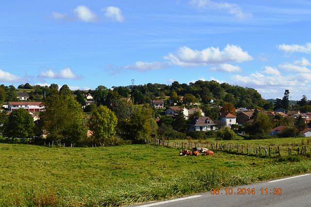
 Hiking in Crachier
Crachier, though not widely known, may refer to hiking areas in regions with picturesque landscapes and trails. If you're interested in a specific location with that name or similar sounding places, I could help you explore general hiking tips and information about various renowned hiking spots.
If you are looking for details about a specific trail, requirements, or conditions for hiking in Crachier, please provide more information or any nearby landmarks or cities that could clarify your request! In the meantime, here are some general tips for hiking:
-
Trail Research: Check online resources for trail maps, difficulty levels, and conditions. Websites like AllTrails and local hiking groups can provide valuable insights.
-
Pack Wisely: Bring essentials such as water, snacks, a first-aid kit, navigation tools, and adequate clothing.
-
Safety First: Always inform someone about your hiking plans, and consider using a GPS or compass if you venture into less trafficked areas.
-
Leave No Trace: Follow Leave No Trace principles to minimize your impact on nature.
-
Wear Appropriate Footwear: Ensure your shoes or boots are suitable for hiking and provide good support.
Feel free to ask if you have specific questions or need tips tailored to certain areas!
- Country:

- Postal Code: 38300
- Coordinates: 45° 32' 54" N, 5° 13' 32" E


- GPS tracks (wikiloc): [Link]
- Area: 3.64 sq km
- Population: 494
- Wikipedia en: wiki(en)
- Wikipedia: wiki(fr)
- Wikidata storage: Wikidata: Q1009038
- Wikipedia Commons Category: [Link]
- Freebase ID: [/m/03nvhmz]
- GeoNames ID: Alt: [6433181]
- SIREN number: [213801368]
- BnF ID: [152579592]
- INSEE municipality code: 38136
Shares border with regions:


Saint-Agnin-sur-Bion
- commune in Isère, France
Hiking in Saint-Agnin-sur-Bion
Saint-Agnin-sur-Bion is a small commune located in the Auvergne-Rhône-Alpes region of France, known for its beautiful natural landscapes and opportunities for outdoor activities, including hiking....
- Country:
- Postal Code: 38300
- Coordinates: 45° 32' 26" N, 5° 14' 39" E
- GPS tracks (wikiloc): [Link]
- Area: 9.7 sq km
- Population: 993
- Web site: [Link]


Maubec
- commune in Isère, France
Hiking in Maubec
Maubec, a small commune in the department of Isère in the Auvergne-Rhône-Alpes region of France, offers a charming backdrop for hiking enthusiasts. Nestled in the picturesque French Alps, it provides access to a variety of trails suitable for different skill levels, ranging from easy walks to more challenging hikes....
- Country:
- Postal Code: 38300
- Coordinates: 45° 34' 6" N, 5° 15' 57" E
- GPS tracks (wikiloc): [Link]
- Area: 8.57 sq km
- Population: 1704
- Web site: [Link]

Artas
- commune in Isère, France
Hiking in Artas
Artas, located in the Isère department of the Auvergne-Rhône-Alpes region in southeastern France, is known for its beautiful landscapes and diverse hiking opportunities. Though small, the area surrounding Artas features a variety of trails that cater to different levels of hikers, from beginners to more experienced mountain trekkers....
- Country:
- Postal Code: 38440
- Coordinates: 45° 32' 7" N, 5° 9' 52" E
- GPS tracks (wikiloc): [Link]
- Area: 14.15 sq km
- Population: 1817
- Web site: [Link]

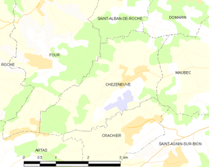
Chèzeneuve
- commune in Isère, France
Hiking in Chèzeneuve
Chèzeneuve is a charming area located in the Auvergne-Rhône-Alpes region of France, known for its beautiful landscapes, rolling hills, and outdoor activities, including hiking. The region provides a range of hiking trails suitable for various skill levels, from gentle strolls to more challenging treks....
- Country:
- Postal Code: 38300
- Coordinates: 45° 33' 44" N, 5° 13' 24" E
- GPS tracks (wikiloc): [Link]
- Area: 6.79 sq km
- Population: 550