Maubec (Maubec)

- commune in Isère, France
 Hiking in Maubec
Maubec, a small commune in the department of Isère in the Auvergne-Rhône-Alpes region of France, offers a charming backdrop for hiking enthusiasts. Nestled in the picturesque French Alps, it provides access to a variety of trails suitable for different skill levels, ranging from easy walks to more challenging hikes.
Hiking Highlights in Maubec:
-
Scenic Views: The area around Maubec features stunning landscapes, including rolling hills, valleys, and panoramic views of the surrounding mountains. The accessible terrain provides great opportunities for both photography and immersing oneself in nature.
-
Diverse Trails: Whether you're a beginner or an experienced hiker, there are trails available that cater to all levels. You can find gentle paths that are great for family outings and more strenuous routes for seasoned hikers seeking adventure.
-
Flora and Fauna: The region is rich in biodiversity, and you'll have the chance to encounter various plant species and wildlife. The changing seasons also bring about beautiful floral displays, especially in spring and summer.
-
Cultural Elements: Hiking in the area can also lead you to discover historical sites and local culture. Keep an eye out for charming villages, ancient architecture, and perhaps even local markets.
-
Accessibility: Maubec is conveniently located near other hiking hotspots in Isère, making it an excellent base for exploring the broader region. You may enjoy easy access to nearby natural parks and protected areas.
Tips for Hiking in Maubec:
- Check Weather Conditions: The weather in the Alps can change rapidly, so it's wise to check conditions before heading out.
- Footwear and Equipment: Wear sturdy hiking boots and appropriate clothing layers. It's also advisable to carry a map or GPS for navigation, especially on less marked trails.
- Stay Hydrated: Bring enough water and snacks for your hike, particularly on longer excursions.
- Respect Nature: Follow Leave No Trace principles to minimize your impact on the environment. Enjoy the beauty of the region while preserving it for others.
Whether you're looking for a peaceful hike through nature or an adventurous day on the trails, Maubec in Isère has something to offer every hiking enthusiast. Happy hiking!
- Country:

- Postal Code: 38300
- Coordinates: 45° 34' 6" N, 5° 15' 57" E


- GPS tracks (wikiloc): [Link]
- Area: 8.57 sq km
- Population: 1704
- Web site: http://www.maubec-isere.fr
- Wikipedia en: wiki(en)
- Wikipedia: wiki(fr)
- Wikidata storage: Wikidata: Q1069167
- Wikipedia Commons Category: [Link]
- Freebase ID: [/m/03nvhy7]
- GeoNames ID: Alt: [6433236]
- SIREN number: [213802234]
- BnF ID: [15258037h]
- VIAF ID: Alt: [244804910]
- Library of Congress authority ID: Alt: [no2015146040]
- INSEE municipality code: 38223
Shares border with regions:


Domarin
- commune in Isère, France
Hiking in Domarin
Domarin is a small town located in Slovenia, surrounded by stunning natural landscapes ideal for hiking enthusiasts. The area offers a variety of trails suitable for different skill levels, making it a great destination for both beginners and experienced hikers....
- Country:
- Postal Code: 38300
- Coordinates: 45° 35' 8" N, 5° 14' 39" E
- GPS tracks (wikiloc): [Link]
- Area: 2.99 sq km
- Population: 1556
- Web site: [Link]

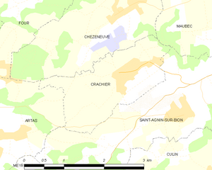
Crachier
- commune in Isère, France
Hiking in Crachier
Crachier, though not widely known, may refer to hiking areas in regions with picturesque landscapes and trails. If you're interested in a specific location with that name or similar sounding places, I could help you explore general hiking tips and information about various renowned hiking spots....
- Country:
- Postal Code: 38300
- Coordinates: 45° 32' 54" N, 5° 13' 32" E
- GPS tracks (wikiloc): [Link]
- Area: 3.64 sq km
- Population: 494


Saint-Agnin-sur-Bion
- commune in Isère, France
Hiking in Saint-Agnin-sur-Bion
Saint-Agnin-sur-Bion is a small commune located in the Auvergne-Rhône-Alpes region of France, known for its beautiful natural landscapes and opportunities for outdoor activities, including hiking....
- Country:
- Postal Code: 38300
- Coordinates: 45° 32' 26" N, 5° 14' 39" E
- GPS tracks (wikiloc): [Link]
- Area: 9.7 sq km
- Population: 993
- Web site: [Link]


Meyrié
- commune in Isère, France
Hiking in Meyrié
Meyrié is a lesser-known gem for hikers, often appreciated for its natural beauty and tranquility. Located in the French Alps, it offers a range of hiking trails suitable for different skill levels, from leisurely strolls to more challenging treks....
- Country:
- Postal Code: 38300
- Coordinates: 45° 33' 34" N, 5° 17' 14" E
- GPS tracks (wikiloc): [Link]
- Area: 3.43 sq km
- Population: 1022
- Web site: [Link]
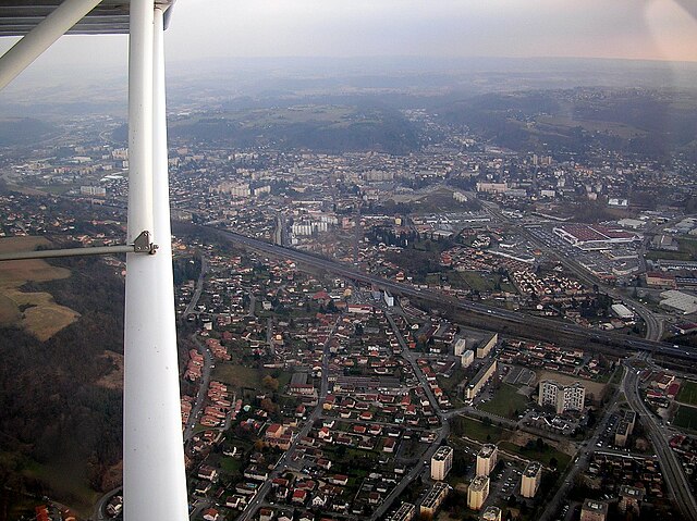

Bourgoin-Jallieu
- commune in Isère, France
Hiking in Bourgoin-Jallieu
Bourgoin-Jallieu, located in the Auvergne-Rhône-Alpes region of eastern France, offers a variety of hiking opportunities for outdoor enthusiasts. The town is nestled between the Isère River and the Chartreuse Mountains, providing both flat terrain and more challenging trails....
- Country:
- Postal Code: 38300
- Coordinates: 45° 35' 27" N, 5° 16' 45" E
- GPS tracks (wikiloc): [Link]
- AboveSeaLevel: 254 м m
- Area: 24.37 sq km
- Population: 27502
- Web site: [Link]

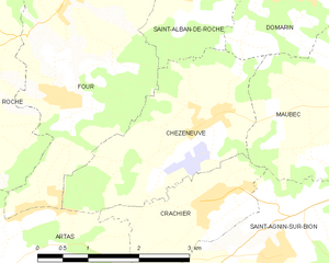
Chèzeneuve
- commune in Isère, France
Hiking in Chèzeneuve
Chèzeneuve is a charming area located in the Auvergne-Rhône-Alpes region of France, known for its beautiful landscapes, rolling hills, and outdoor activities, including hiking. The region provides a range of hiking trails suitable for various skill levels, from gentle strolls to more challenging treks....
- Country:
- Postal Code: 38300
- Coordinates: 45° 33' 44" N, 5° 13' 24" E
- GPS tracks (wikiloc): [Link]
- Area: 6.79 sq km
- Population: 550