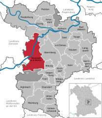
Dürnbucher Forst (Dürnbucher Forst)
- unincorporated area in Germany
Dürnbucher Forst, located near the urban area of Regensburg in Bavaria, Germany, is a beautiful destination for hiking enthusiasts. The forest is characterized by its lush greenery, diverse plant life, and serene atmosphere, making it ideal for nature walks and outdoor activities. Here are some key points to consider if you’re planning a hike in Dürnbucher Forst:
Trails
- Variety of Trails: Dürnbucher Forst offers various hiking trails, ranging from easy paths suitable for families and beginners to more challenging routes for experienced hikers. The trails are usually well-marked, allowing for a straightforward navigation experience.
- Loop Trails: Many of the routes are loop trails, so hikers can enjoy different scenery without retracing their steps.
Scenery
- Natural Beauty: Expect to see a mix of deciduous and coniferous trees, making it an appealing spot throughout the year, especially during autumn when the leaves change colors.
- Wildlife: The forest is home to various species of birds and wildlife, so keep your camera ready for possible sightings!
Amenities
- Facilities: While the forest itself is quite natural, check for nearby amenities such as parking areas, restrooms, and possibly picnic spots. There are often nearby villages where you can find eateries or cafes if you need refreshments post-hike.
- Guided Tours: If you prefer not to hike alone, consider joining a guided tour to learn more about the local flora and fauna.
Tips for Hiking
- Gear: Wear proper hiking boots and clothing suited for the weather. Depending on the season, you might also want to bring a hat, sunscreen, or insect repellent.
- Stay Hydrated: Always take plenty of water, especially during warmer months.
- Map: Although trails are marked, it can be helpful to carry a local map or a GPS device for added safety.
Accessibility
- Proximity to Regensburg: Being close to Regensburg makes Dürnbucher Forst easily accessible for a day trip. It’s a great escape from the bustling city while still being close enough for convenience.
Overall, Dürnbucher Forst offers a lovely hiking experience with its scenic landscape, diverse trails, and the tranquility of nature. Whether you are looking for a leisurely stroll or a more vigorous hike, this forest provides an ideal setting to explore the outdoors.
- Country:

- Coordinates: 48° 44' 0" N, 11° 44' 0" E


- GPS tracks (wikiloc): [Link]
- Wikidata storage: Wikidata: Q887697
- Wikipedia Commons Category: [Link]
- GeoNames ID: Alt: [2934438]
- OSM relation ID: [956654]
- Bavarikon ID: [ODB_A00002171]
Shares border with regions:


Vohburg an der Donau
- town in Bavaria, Germany
 Hiking in Vohburg an der Donau
Vohburg, located in Bavaria, Germany, offers a variety of hiking opportunities that can appeal to both casual walkers and more serious hikers. Here are some highlights and tips for hiking in and around Vohburg:...
- Country:

- Postal Code: 85088
- Local Dialing Code: 08457
- Licence Plate Code: PAF
- Coordinates: 48° 46' 11" N, 11° 37' 6" E


- GPS tracks (wikiloc): [Link]
- AboveSeaLevel: 371 м m
- Area: 45.19 sq km
- Population: 5863
- Web site: [Link]


Neustadt an der Donau
- municipality of Germany
 Hiking in Neustadt an der Donau
Neustadt an der Donau, located in Bavaria, Germany, is a charming area that offers a variety of hiking opportunities, thanks to its scenic landscapes, historic sites, and proximity to the Danube River. Here's what you should know when planning your hiking adventures in and around Neustadt an der Donau:...
- Country:

- Postal Code: 93333
- Local Dialing Code: 09445
- Licence Plate Code: KEH
- Coordinates: 48° 48' 25" N, 11° 46' 10" E


- GPS tracks (wikiloc): [Link]
- AboveSeaLevel: 357 м m
- Area: 93.55 sq km
- Population: 9811
- Web site: [Link]
