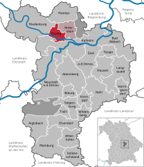
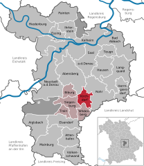
Kelheim (Landkreis Kelheim)

- district in Bavaria, Germany
 Hiking in Kelheim
Kelheim, located in Bavaria, Germany, is a beautiful area for hiking, characterized by its stunning landscapes, historical sites, and natural attractions. Here are some highlights you might consider when planning a hiking trip in Kelheim:
1.
- The Danube Gorge is one of the most picturesque hiking areas in the region. You can enjoy a variety of trails that take you along the river and through the gorge, offering breathtaking views of the steep cliffs and the Danube River.
2.
- A must-visit when in Kelheim, Weltenburg Abbey is not only an architectural marvel but also a great stop on your hike. You can hike to the abbey from the town and enjoy local food and drink at their brewery.
3.
- The areas surrounding Kelheim are part of the UNESCO Biosphere Reserve of the Danube Valley. The protection of this biosphere means you’ll encounter diverse flora and fauna along the trails.
4.
- There are numerous well-marked hiking trails ranging from easy walks to more challenging paths. Some trails lead to scenic viewpoints like the “Blick auf Weltenburg” or to panoramic spots overlooking the Danube. The Trail of the Liberation offers historical insights along with natural beauty.
5.
- As you hike, you might come across various historical landmarks, such as the Liberation Hall (Hall der Völker), which can be reached via a scenic hike from Kelheim. It’s an impressive monument with stunning views of the surrounding area.
6.
- Spring and early autumn are ideal times for hiking due to mild weather and colorful landscapes. However, summer can be rewarding too, especially with all the lush greenery, but be prepared for warmer temperatures.
7.
- If you prefer, you can join guided hikes led by local experts, which can enhance your experience by providing insights into the local ecosystem, history, and culture.
8.
- Depending on the terrain and your fitness level, ensure you have proper hiking boots, weather-appropriate clothing, water, snacks, and a map or GPS device.
Safety Tips
- Always let someone know your hiking plans.
- Check weather conditions beforehand.
- Stay on marked trails to protect the environment.
Hiking in Kelheim offers a unique blend of natural beauty and historical significance, which makes it a fantastic destination for outdoor enthusiasts. Enjoy your adventure!
- Country:

- Capital: Kelheim
- Licence Plate Code: ROL; RID; PAR; MAI; KEH
- Coordinates: 48° 49' 48" N, 11° 49' 48" E


- GPS tracks (wikiloc): [Link]
- AboveSeaLevel: 369 м m
- Area: 1067.00 sq km
- Population: 90040
- Web site: http://www.landkreis-kelheim.de/
- Wikipedia en: wiki(en)
- Wikipedia: wiki(de)
- Wikidata storage: Wikidata: Q10474
- Wikipedia Commons Category: [Link]
- Wikipedia Commons Maps Category: [Link]
- Freebase ID: [/m/01wchs]
- GeoNames ID: Alt: [3220809]
- VIAF ID: Alt: [139563157]
- OSM relation ID: [62614]
- GND ID: Alt: [4030175-8]
- archINFORM location ID: [2472]
- Library of Congress authority ID: Alt: [n81053322]
- TGN ID: [7077309]
- Historical Gazetteer (GOV) ID: [adm_139273]
- Bavarikon ID: [ODB_A00002372]
- ISNI: Alt: [0000 0004 0394 5122]
- NUTS code: [DE226]
- Ringgold ID: [155871]
- BabelNet ID: [02632202n]
- German district key: 09273
Includes regions:

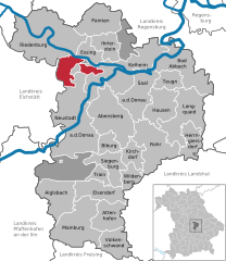
Essing
- municipality in south east Germany
Hiking in Essing
Essing, located in Bavaria, Germany, is a picturesque village known for its stunning natural landscapes and proximity to the Altmühltaler Urstromtal. Hiking in this area offers a variety of beautiful trails that cater to different experience levels, making it a great destination for both novice and seasoned hikers....
- Country:
- Postal Code: 93343
- Local Dialing Code: 09447
- Licence Plate Code: KEH
- Coordinates: 48° 56' 4" N, 11° 47' 24" E
- GPS tracks (wikiloc): [Link]
- AboveSeaLevel: 351 м m
- Area: 17.32 sq km
- Population: 1032
- Web site: [Link]


Bad Abbach
- municipality in the district Kelheim, Bavaria, Germany
Hiking in Bad Abbach
Bad Abbach, located in Bavaria, Germany, is known for its beautiful landscapes and proximity to the Danube River. Here are some highlights and tips for hiking in this region:...
- Country:
- Postal Code: 93074–93077
- Local Dialing Code: 09405
- Licence Plate Code: KEH
- Coordinates: 48° 56' 0" N, 12° 3' 0" E
- GPS tracks (wikiloc): [Link]
- AboveSeaLevel: 371 м m
- Area: 55.26 sq km
- Population: 12241
- Web site: [Link]
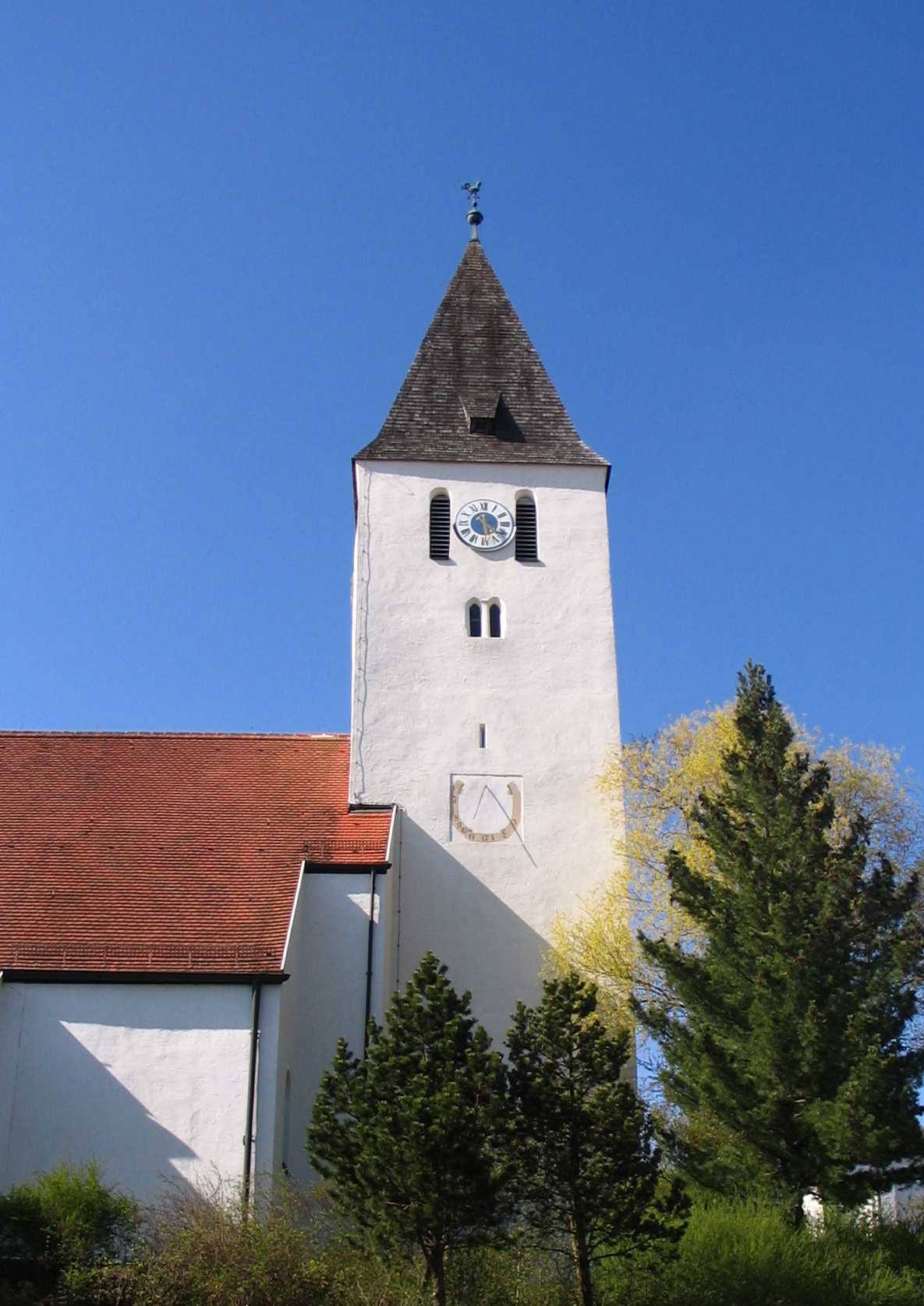

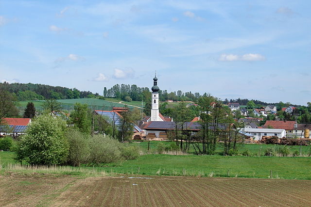
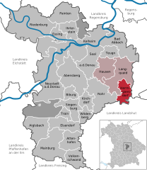
Teugn
- municipality of Germany
Hiking in Teugn
Teugn is a charming area in Bavaria, Germany, known for its scenic landscapes and outdoor activities, including hiking. Here are some key points about hiking in Teugn:...
- Country:
- Postal Code: 93356
- Local Dialing Code: 09405
- Licence Plate Code: KEH
- Coordinates: 48° 53' 35" N, 12° 0' 42" E
- GPS tracks (wikiloc): [Link]
- AboveSeaLevel: 388 м m
- Area: 17.07 sq km
- Population: 1220
- Web site: [Link]


Abensberg
- town in Bavaria
Hiking in Abensberg
Abensberg, located in Bavaria, Germany, is a charming small town known for its rich history and beautiful landscapes, making it a nice destination for hikers. Here are some highlights and tips for hiking in and around Abensberg:...
- Country:
- Postal Code: 93326
- Local Dialing Code: 09443
- Licence Plate Code: KEH
- Coordinates: 48° 48' 39" N, 11° 51' 34" E
- GPS tracks (wikiloc): [Link]
- AboveSeaLevel: 370 м m
- Area: 60.27 sq km
- Population: 13540
- Web site: [Link]

Elsendorf
- municipality of Germany
Hiking in Elsendorf
Elsendorf, located in the region of Bavaria, Germany, is a quaint village surrounded by beautiful natural landscapes. While it may not be as popular as some other hiking destinations, it offers several opportunities for hikers to explore the picturesque countryside....
- Country:
- Postal Code: 84094
- Local Dialing Code: 08753
- Licence Plate Code: KEH
- Coordinates: 48° 42' 0" N, 11° 49' 0" E
- GPS tracks (wikiloc): [Link]
- AboveSeaLevel: 439 м m
- Area: 32.63 sq km
- Population: 1616
- Web site: [Link]


Aiglsbach
- municipality of Germany
Hiking in Aiglsbach
Aiglsbach, located in Bavaria, Germany, offers a peaceful and beautiful setting for hiking enthusiasts. The area is characterized by gentle hills, lush forests, and picturesque lakes, making it an excellent destination for both casual walkers and more experienced hikers....
- Country:
- Postal Code: 84089
- Local Dialing Code: 08753
- Licence Plate Code: KEH
- Coordinates: 48° 42' 0" N, 11° 43' 0" E
- GPS tracks (wikiloc): [Link]
- AboveSeaLevel: 415 м m
- Area: 39.85 sq km
- Population: 1331
- Web site: [Link]

Herrngiersdorf
- municipality of Germany
Hiking in Herrngiersdorf
Herrngiersdorf is a small village located in Bavaria, Germany, and it offers a wonderful experience for hiking enthusiasts. While it may not be as renowned as other hiking destinations, its surrounding landscapes provide charming trails and a glimpse into the scenic beauty of the Bavarian countryside....
- Country:
- Postal Code: 84097
- Local Dialing Code: 09452
- Licence Plate Code: KEH
- Coordinates: 48° 48' 0" N, 12° 4' 0" E
- GPS tracks (wikiloc): [Link]
- AboveSeaLevel: 405 м m
- Area: 25.08 sq km
- Population: 1010
- Web site: [Link]


Hausen
- municipality of Germany, Lower Bavaria
Hiking in Hausen
Hausen, located in Lower Bavaria, Germany, is a charming area that offers various hiking opportunities, particularly in the beautiful landscapes that characterize the region. Here are some highlights and tips for hiking in Hausen:...
- Country:
- Postal Code: 93345
- Local Dialing Code: 09448
- Licence Plate Code: KEH
- Coordinates: 48° 51' 0" N, 12° 0' 0" E
- GPS tracks (wikiloc): [Link]
- AboveSeaLevel: 384 м m
- Area: 34.59 sq km
- Population: 1720
- Web site: [Link]

Kirchdorf
- municipality of Germany
Hiking in Kirchdorf
Kirchdorf, located in Lower Bavaria, is a fantastic destination for hiking enthusiasts. Nestled in the beautiful landscapes of the Bavarian region, it offers a variety of trails that cater to different skill levels, from leisurely walks to more challenging hikes. Here’s an overview of what you can expect when hiking in Kirchdorf:...
- Country:
- Postal Code: 93348
- Local Dialing Code: 09444; 08783
- Licence Plate Code: KEH
- Coordinates: 48° 46' 0" N, 11° 55' 0" E
- GPS tracks (wikiloc): [Link]
- AboveSeaLevel: 412 м m
- Area: 16.49 sq km
- Population: 735
- Web site: [Link]

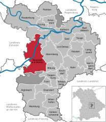
Neustadt an der Donau
- municipality of Germany
Hiking in Neustadt an der Donau
Neustadt an der Donau, located in Bavaria, Germany, is a charming area that offers a variety of hiking opportunities, thanks to its scenic landscapes, historic sites, and proximity to the Danube River. Here's what you should know when planning your hiking adventures in and around Neustadt an der Donau:...
- Country:
- Postal Code: 93333
- Local Dialing Code: 09445
- Licence Plate Code: KEH
- Coordinates: 48° 48' 25" N, 11° 46' 10" E
- GPS tracks (wikiloc): [Link]
- AboveSeaLevel: 357 м m
- Area: 93.55 sq km
- Population: 9811
- Web site: [Link]

Biburg
- municipality of Germany
Hiking in Biburg
Biburg, located in Bavaria, Germany, offers various hiking opportunities that showcase the natural beauty and picturesque landscapes typical of the region. Here are some highlights and tips for hiking in and around Biburg:...
- Country:
- Postal Code: 93354
- Local Dialing Code: 09444; 09443
- Licence Plate Code: KEH
- Coordinates: 48° 48' 0" N, 11° 52' 0" E
- GPS tracks (wikiloc): [Link]
- AboveSeaLevel: 368 м m
- Area: 14.21 sq km
- Population: 939
- Web site: [Link]


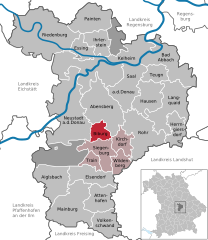
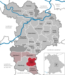
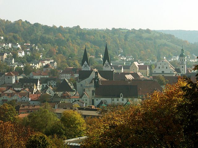
Kelheim
- municipality of Germany
Hiking in Kelheim
Kelheim, located in Bavaria, Germany, is a fantastic destination for hikers and nature enthusiasts. It is situated at the confluence of the Danube and Altmühl Rivers, surrounded by picturesque landscapes, limestone cliffs, and a variety of hiking trails that cater to all levels of experience. Here are some highlights and tips for hiking in Kelheim:...
- Country:
- Postal Code: 93309
- Local Dialing Code: 09441
- Licence Plate Code: KEH
- Coordinates: 48° 55' 0" N, 11° 52' 0" E
- GPS tracks (wikiloc): [Link]
- AboveSeaLevel: 345 м m
- Area: 76.68 sq km
- Population: 16716
- Web site: [Link]


Painten
- municipality of Germany
Hiking in Painten
Painten, a charming village located in Bavaria, Germany, offers some delightful hiking opportunities amidst its scenic countryside and natural landscapes. Here are some key points to consider if you're planning to hike in and around Painten:...
- Country:
- Postal Code: 93351
- Local Dialing Code: 09499
- Licence Plate Code: KEH
- Coordinates: 49° 0' 0" N, 11° 49' 0" E
- GPS tracks (wikiloc): [Link]
- AboveSeaLevel: 490 м m
- Area: 36.89 sq km
- Population: 1878
- Web site: [Link]

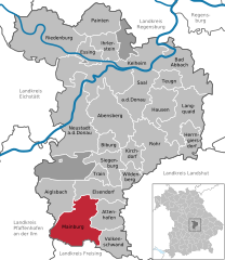
Mainburg
- municipality of Germany
Hiking in Mainburg
Mainburg is a charming town located in Bavaria, Germany, and while it may not be as widely known for hiking as some of the more mountainous regions of the country, there are still opportunities for enjoying the outdoors in and around the area. Here are some highlights for hiking enthusiasts in Mainburg:...
- Country:
- Postal Code: 84042–84048
- Local Dialing Code: 08751
- Coordinates: 48° 36' 13" N, 11° 46' 22" E
- GPS tracks (wikiloc): [Link]
- AboveSeaLevel: 439 м m
- Area: 61.54 sq km
- Population: 14855
- Web site: [Link]

Attenhofen
- municipality of Germany
Hiking in Attenhofen
Attenhofen is a charming village located in Bavaria, Germany, surrounded by picturesque landscapes that are ideal for hiking enthusiasts. While it may not be as well-known as some larger hiking destinations, it offers a variety of scenic trails and natural beauty....
- Country:
- Postal Code: 84091
- Local Dialing Code: 08751
- Licence Plate Code: KEH
- Coordinates: 48° 39' 0" N, 11° 51' 0" E
- GPS tracks (wikiloc): [Link]
- AboveSeaLevel: 465 м m
- Area: 31.42 sq km
- Population: 1055
- Web site: [Link]


Riedenburg
- municipality of Germany
Hiking in Riedenburg
Riedenburg, located in Bavaria, Germany, is a charming town surrounded by beautiful landscapes, making it a fantastic destination for hiking enthusiasts. Here are some highlights and tips for hiking in the area:...
- Country:
- Postal Code: 93339
- Local Dialing Code: 09442
- Coordinates: 48° 58' 0" N, 11° 40' 0" E
- GPS tracks (wikiloc): [Link]
- AboveSeaLevel: 360 м m
- Area: 100.3 sq km
- Population: 4878
- Web site: [Link]

Ihrlerstein
- municipality of Germany
Hiking in Ihrlerstein
Ihrlerstein is a picturesque area in Bavaria, Germany, known for its beautiful landscapes and outdoor recreational opportunities, including hiking. Nestled near the Danube River, the region is characterized by rolling hills, forests, and charming views....
- Country:
- Postal Code: 93346
- Local Dialing Code: 09441
- Licence Plate Code: KEH
- Coordinates: 48° 56' 0" N, 11° 52' 0" E
- GPS tracks (wikiloc): [Link]
- AboveSeaLevel: 482 м m
- Area: 23.04 sq km
- Population: 3583
- Web site: [Link]


Saal an der Donau
- municipality of Germany
Hiking in Saal an der Donau
Saal an der Donau, located in Bavaria, Germany, is a charming small town nestled along the banks of the Danube River. It's surrounded by beautiful natural landscapes and offers various hiking opportunities for enthusiasts of all levels. Here are some highlights and tips for hiking in the area:...
- Country:
- Postal Code: 93342
- Local Dialing Code: 09448; 09441
- Licence Plate Code: KEH
- Coordinates: 48° 53' 0" N, 11° 55' 0" E
- GPS tracks (wikiloc): [Link]
- AboveSeaLevel: 346 м m
- Area: 44.01 sq km
- Population: 5216
- Web site: [Link]


Siegenburg
- municipality of Germany
Hiking in Siegenburg
Siegenburg, located in Bavaria, Germany, offers a unique hiking experience with its picturesque landscapes and charming countryside. The area features a variety of trails suitable for different skill levels, making it an excellent destination for both casual hikers and more experienced trekkers....
- Country:
- Postal Code: 93354
- Local Dialing Code: 09444
- Licence Plate Code: KEH
- Coordinates: 48° 45' 0" N, 11° 51' 0" E
- GPS tracks (wikiloc): [Link]
- AboveSeaLevel: 392 м m
- Area: 27.84 sq km
- Population: 2384
- Web site: [Link]


Wildenberg
- municipality of Germany
Hiking in Wildenberg
Wildenberg is a scenic region that offers a variety of hiking opportunities, often characterized by its lush landscapes, diverse ecosystems, and charming trails. While I may not have specific up-to-date information on Wildenberg itself, I can guide you on general tips for hiking in such areas....
- Country:
- Postal Code: 93359
- Local Dialing Code: 09444
- Licence Plate Code: KEH
- Coordinates: 48° 44' 0" N, 11° 55' 0" E
- GPS tracks (wikiloc): [Link]
- AboveSeaLevel: 430 м m
- Area: 18.16 sq km
- Population: 1068
- Web site: [Link]


Volkenschwand
- municipality in the district of Kelheim in Bavaria in Germany
Hiking in Volkenschwand
Volkenschwand, a picturesque village located in Bavaria, Germany, offers a variety of hiking opportunities for outdoor enthusiasts. The region is characterized by its scenic landscapes, rolling hills, and charming woodlands, making it an ideal spot for both leisurely walks and more challenging hikes....
- Country:
- Postal Code: 84106
- Local Dialing Code: 08754
- Licence Plate Code: KEH
- Coordinates: 48° 36' 0" N, 11° 53' 0" E
- GPS tracks (wikiloc): [Link]
- AboveSeaLevel: 503 м m
- Area: 29.23 sq km
- Population: 1384
- Web site: [Link]


Langquaid
- municipality in Germany
Hiking in Langquaid
Langquaid, a charming village located in Bavaria, Germany, is surrounded by picturesque landscapes and offers a variety of hiking opportunities. The region is characterized by its rolling hills, meadows, and forests, making it a great destination for nature lovers and hiking enthusiasts....
- Country:
- Postal Code: 84083–84085
- Local Dialing Code: 09452
- Licence Plate Code: KEH
- Coordinates: 48° 49' 0" N, 12° 3' 0" E
- GPS tracks (wikiloc): [Link]
- AboveSeaLevel: 389 м m
- Area: 56.77 sq km
- Population: 3777
- Web site: [Link]


Rohr in Niederbayern
- municipality of Germany
Hiking in Rohr in Niederbayern
Rohr in Niederbayern, located in the Lower Bavaria region of Germany, is surrounded by beautiful landscapes that are ideal for hiking. The area features a mix of scenic forests, rolling hills, and charming villages, making it a great destination for outdoor enthusiasts....
- Country:
- Postal Code: 93352
- Local Dialing Code: 08783
- Licence Plate Code: KEH
- Coordinates: 48° 46' 0" N, 11° 58' 0" E
- GPS tracks (wikiloc): [Link]
- AboveSeaLevel: 426 м m
- Area: 54.12 sq km
- Population: 2956
- Web site: [Link]


Train
- municipality in Kelheim, Bavaria, Germany
Hiking in Train
Hiking in Train, Bavaria, is a delightful experience, as the region is known for its picturesque landscapes, charming villages, and scenic trails. Train is situated near Munich and is part of the stunning Bavarian countryside, offering easy access to a variety of hiking options. Here are some highlights you can expect:...
- Country:
- Postal Code: 93358
- Local Dialing Code: 09444
- Licence Plate Code: KEH
- Coordinates: 48° 44' 0" N, 11° 50' 0" E
- GPS tracks (wikiloc): [Link]
- AboveSeaLevel: 422 м m
- Area: 10.15 sq km
- Population: 1347
- Web site: [Link]


Dürnbucher Forst
- unincorporated area in Germany
Hiking in Dürnbucher Forst
Dürnbucher Forst, located near the urban area of Regensburg in Bavaria, Germany, is a beautiful destination for hiking enthusiasts. The forest is characterized by its lush greenery, diverse plant life, and serene atmosphere, making it ideal for nature walks and outdoor activities. Here are some key points to consider if you’re planning a hike in Dürnbucher Forst:...
- Country:
- Coordinates: 48° 44' 0" N, 11° 44' 0" E
- GPS tracks (wikiloc): [Link]
Frauenforst
- unincorporated area in Germany
Hiking in Frauenforst
Frauenforst, located in Germany, is a beautiful area known for its picturesque landscapes and diverse hiking trails. Here are some key points to consider if you're planning to hike in Frauenforst:...
- Country:
- Coordinates: 48° 57' 0" N, 11° 53' 0" E
- GPS tracks (wikiloc): [Link]
- AboveSeaLevel: 488 м m
Hacklberg
- unincorporated area in Germany
Hiking in Hacklberg
Gemeindefreies Gebiet Hacklberg is located in the district of Passau in Bavaria, Germany. This area encompasses lush natural landscapes, offering tranquil settings for hiking enthusiasts. While there are no formal trails specifically designated within the gemeindefreiesgebiet, there are numerous paths and routes that you can explore, particularly around the scenic areas near the Danube River and wooded regions....
- Country:
- Coordinates: 48° 55' 0" N, 11° 46' 0" E
- GPS tracks (wikiloc): [Link]
Hienheimer Forst
- unincorporated area in Germany
Hiking in Hienheimer Forst
Hienheimer Forst is a beautiful forested area located in Germany, primarily known for its picturesque landscapes and rich biodiversity. When planning a hiking trip in Hienheimer Forst, here are some key points to consider:...
- Country:
- Coordinates: 48° 54' 0" N, 11° 44' 0" E
- GPS tracks (wikiloc): [Link]
Shares border with regions:

Neumarkt
- district of Bavaria, Germany
Hiking in Neumarkt
Neumarkt in der Oberpfalz, a district in Bavaria, Germany, is known for its picturesque landscapes and varied hiking opportunities. Set against a backdrop of rolling hills, lush forests, and charming villages, this area is ideal for both casual walkers and seasoned hikers....
- Country:
- Capital: Neumarkt in der Oberpfalz
- Licence Plate Code: PAR; NM
- Coordinates: 49° 15' 0" N, 11° 30' 0" E
- GPS tracks (wikiloc): [Link]
- AboveSeaLevel: 445 м m
- Area: 1344.00 sq km
- Population: 105346
- Web site: [Link]

Regensburg
- district of Bavaria, Germany
Hiking in Regensburg
Regensburg is located in the state of Bavaria, Germany, and it offers a variety of hiking opportunities that showcase the region's natural beauty and historical significance. Here's what you can expect when hiking in and around the Regensburg district:...
- Country:
- Capital: Regensburg
- Licence Plate Code: R
- Coordinates: 49° 4' 48" N, 12° 10' 12" E
- GPS tracks (wikiloc): [Link]
- AboveSeaLevel: 390 м m
- Area: 1396.00 sq km
- Population: 144278
- Web site: [Link]

Landshut
- district in Bavaria, Germany
Hiking in Landshut
Landshut district, located in Bavaria, Germany, offers a variety of hiking opportunities that cater to different skill levels and preferences. The landscape is characterized by rolling hills, picturesque villages, and lush forests, providing a beautiful backdrop for outdoor activities....
- Country:
- Capital: Landshut
- Licence Plate Code: LA
- Coordinates: 48° 34' 14" N, 12° 10' 50" E
- GPS tracks (wikiloc): [Link]
- AboveSeaLevel: 383 м m
- Area: 1348 sq km
- Population: 115644
- Web site: [Link]
Eichstätt
- district of Bavaria, Germany
Hiking in Eichstätt
Eichstätt, located in Bavaria, Germany, is known for its scenic landscapes, historical towns, and rich natural beauty, making it a fantastic destination for hiking enthusiasts. Here are some highlights and tips for hiking in the Eichstätt district:...
- Country:
- Capital: Eichstätt
- Licence Plate Code: EI
- Coordinates: 48° 55' 12" N, 11° 19' 48" E
- GPS tracks (wikiloc): [Link]
- AboveSeaLevel: 475 м m
- Area: 1214.00 sq km
- Population: 97347
- Web site: [Link]

Pfaffenhofen
- district of Bavaria, Germany
Hiking in Pfaffenhofen
Pfaffenhofen is a district in Bavaria, Germany, known for its picturesque landscapes and outdoor recreational opportunities, including hiking. The region features a mix of rolling hills, forests, rivers, and farmland, providing a variety of scenic routes for hikers of all skill levels....
- Country:
- Capital: Pfaffenhofen an der Ilm
- Licence Plate Code: PAF
- Coordinates: 48° 30' 0" N, 11° 30' 0" E
- GPS tracks (wikiloc): [Link]
- AboveSeaLevel: 439 м m
- Area: 760.00 sq km
- Population: 126244
- Web site: [Link]

Freising
- district of Bavaria, Germany
Hiking in Freising
Freising, located in Bavaria, Germany, offers a variety of hiking opportunities suitable for different skill levels and preferences. The district is known for its picturesque landscapes, including rolling hills, scenic views, and lush forests. Here are some highlights if you’re considering hiking in Freising:...
- Country:
- Capital: Freising
- Licence Plate Code: FS
- Coordinates: 48° 30' 0" N, 11° 49' 48" E
- GPS tracks (wikiloc): [Link]
- AboveSeaLevel: 433 м m
- Area: 800.00 sq km
- Population: 118518
- Web site: [Link]