Dangeau (Dangeau)

- former commune in Eure-et-Loir, France
- Country:

- Postal Code: 28160
- Coordinates: 48° 12' 31" N, 1° 17' 5" E


- GPS tracks (wikiloc): [Link]
- Area: 39.63 sq km
- Population: 920
- Web site: http://dangeau.free.fr
- Wikipedia en: wiki(en)
- Wikipedia: wiki(fr)
- Wikidata storage: Wikidata: Q662671
- Wikipedia Commons Category: [Link]
- Freebase ID: [/m/03nqt4_]
- GeoNames ID: Alt: [6430716]
- SIREN number: [212801278]
- BnF ID: [15254058h]
- INSEE municipality code: 28127
Shares border with regions:


Yèvres
- commune in Eure-et-Loir, France
- Country:
- Postal Code: 28160
- Coordinates: 48° 12' 37" N, 1° 11' 25" E
- GPS tracks (wikiloc): [Link]
- Area: 41.75 sq km
- Population: 1680
- Web site: [Link]

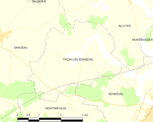
Trizay-lès-Bonneval
- commune in Eure-et-Loir, France
- Country:
- Postal Code: 28800
- Coordinates: 48° 12' 3" N, 1° 20' 8" E
- GPS tracks (wikiloc): [Link]
- Area: 9.77 sq km
- Population: 325