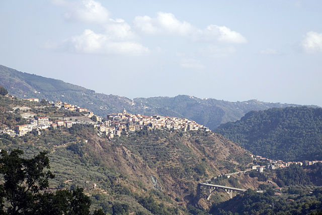
Decollatura (Decollatura)
.svg)
- Italian comune
 Hiking in Decollatura
Decollatura, located in the Calabria region of southern Italy, is known for its beautiful landscapes and rich biodiversity, making it a great destination for hiking enthusiasts. The area is characterized by its rolling hills, rugged terrain, and scenic views of the surrounding mountains and valleys.
Hiking Trails
-
Sentiero della Sila: This trail is part of the Sila National Park, offering stunning views and diverse flora and fauna. It’s suitable for various skill levels and provides a great introduction to the local environment.
-
Monte Cunti: A hike to the summit of Monte Cunti will reward you with panoramic views of the surrounding countryside. The trail is moderately challenging, making it perfect for those looking for a slightly more strenuous adventure.
-
Local Paths: There are several lesser-known paths around Decollatura that provide opportunities to explore the area’s natural beauty, interact with local wildlife, and discover hidden gems such as waterfalls or quaint villages.
Things to Consider
-
Best Time to Hike: Spring and fall are ideal for hiking in Decollatura, as the weather is mild, and the landscape is lush. Summer can be hot, while winter may bring snow to higher elevations.
-
Gear: Good hiking boots are essential, along with appropriate clothing layers, a map or GPS, water, and snacks. Be prepared for sudden weather changes, especially in mountainous areas.
-
Safety: Always let someone know your hiking plans, and consider hiking with a buddy. Familiarize yourself with the route before heading out, and keep an eye on the weather forecast.
Cultural Aspects
Hiking in Decollatura also allows hikers to experience the rich history and culture of the area. You may encounter traditional villages, local cuisine, and historical landmarks along the way.
Conclusion
Decollatura offers a unique hiking experience with a mix of natural beauty and cultural heritage. Whether you're a seasoned hiker or a beginner, the trails in and around this charming area present opportunities for exploration and adventure.
- Country:

- Postal Code: 88041
- Local Dialing Code: 0968
- Licence Plate Code: CZ
- Coordinates: 39° 3' 0" N, 16° 21' 0" E


- GPS tracks (wikiloc): [Link]
- AboveSeaLevel: 744 м m
- Area: 50.83 sq km
- Population: 3163
- Web site: http://decollatura.asmenet.it
- Wikipedia en: wiki(en)
- Wikipedia: wiki(it)
- Wikidata storage: Wikidata: Q53518
- Wikipedia Commons Category: [Link]
- Freebase ID: [/m/0fh4sh]
- GeoNames ID: Alt: [6539855]
- VIAF ID: Alt: [236992373]
- OSM relation ID: [39771]
- GND ID: Alt: [4453151-5]
- WOEID: [714975]
- ISTAT ID: 079043
- Italian cadastre code: D261
Shares border with regions:

Conflenti
- Italian comune
Hiking in Conflenti
Conflenti, a charming municipality in the Calabria region of southern Italy, offers a variety of hiking opportunities that showcase its natural beauty and cultural heritage. Nestled in the Serre Mountains, the area is characterized by its lush landscapes, picturesque villages, and historical sites....
- Country:
- Postal Code: 88040
- Local Dialing Code: 0968
- Licence Plate Code: CZ
- Coordinates: 39° 4' 0" N, 16° 17' 0" E
- GPS tracks (wikiloc): [Link]
- AboveSeaLevel: 550 м m
- Area: 29.34 sq km
- Population: 1396
- Web site: [Link]
Gimigliano
- Italian comune
Hiking in Gimigliano
Gimigliano is a small but charming town in the Calabria region of southern Italy, known for its picturesque landscapes and proximity to the Sila National Park, which offers stunning hiking opportunities. Here are some insights about hiking in and around Gimigliano:...
- Country:
- Postal Code: 88045
- Local Dialing Code: 0961
- Licence Plate Code: CZ
- Coordinates: 38° 58' 0" N, 16° 32' 0" E
- GPS tracks (wikiloc): [Link]
- AboveSeaLevel: 600 м m
- Area: 33.55 sq km
- Population: 3292
- Web site: [Link]

Motta Santa Lucia
- Italian comune
Hiking in Motta Santa Lucia
Motta Santa Lucia is a beautiful hiking destination located in the region of Calabria, Italy. Nestled in the Aspromonte National Park, it offers a variety of trails that showcase the stunning natural landscapes, rich biodiversity, and captivating views of the surrounding mountains and valleys....
- Country:
- Postal Code: 88040
- Local Dialing Code: 0968
- Licence Plate Code: CZ
- Coordinates: 39° 6' 0" N, 16° 18' 0" E
- GPS tracks (wikiloc): [Link]
- AboveSeaLevel: 590 м m
- Area: 26.3 sq km
- Population: 827
- Web site: [Link]

Platania
- Italian comune
Hiking in Platania
Platania, located in Greece, is a beautiful area known for its stunning natural landscapes, which are ideal for hiking enthusiasts. The region is characterized by lush forests, impressive mountainous terrain, and picturesque views of the surrounding countryside. Here are some key highlights and considerations for hiking in Platania:...
- Country:
- Postal Code: 88040
- Local Dialing Code: 0968
- Licence Plate Code: CZ
- Coordinates: 39° 0' 0" N, 16° 19' 0" E
- GPS tracks (wikiloc): [Link]
- AboveSeaLevel: 750 м m
- Area: 26.84 sq km
- Population: 2115
- Web site: [Link]
San Pietro Apostolo
- Italian comune
Hiking in San Pietro Apostolo
San Pietro Apostolo, a small town located in southern Italy, is renowned for its beautiful natural landscapes and hiking opportunities. Here are some key aspects to consider when planning a hiking adventure in this area:...
- Country:
- Postal Code: 88040
- Local Dialing Code: 0961
- Licence Plate Code: CZ
- Coordinates: 39° 0' 0" N, 16° 28' 0" E
- GPS tracks (wikiloc): [Link]
- AboveSeaLevel: 780 м m
- Area: 11.72 sq km
- Population: 1693
- Web site: [Link]
Serrastretta
- Italian comune
Hiking in Serrastretta
Serrastretta, located in the beautiful region of Calabria, Italy, offers a variety of hiking trails that cater to different skill levels, along with stunning views of the surrounding mountains and valleys. Here are some key points about hiking in Serrastretta:...
- Country:
- Postal Code: 88040
- Local Dialing Code: 0968
- Licence Plate Code: CZ
- Coordinates: 39° 1' 0" N, 16° 24' 0" E
- GPS tracks (wikiloc): [Link]
- AboveSeaLevel: 840 м m
- Area: 41.65 sq km
- Population: 3107
- Web site: [Link]

Soveria Mannelli
- Italian comune
Hiking in Soveria Mannelli
Soveria Mannelli is a charming town located in the Calabria region of southern Italy, known for its stunning landscapes, rich history, and outdoor activities, including hiking. Nestled in the Sila National Park, this area offers a variety of trails that cater to different skill levels....
- Country:
- Postal Code: 88049
- Local Dialing Code: 0968
- Licence Plate Code: CZ
- Coordinates: 39° 5' 0" N, 16° 22' 0" E
- GPS tracks (wikiloc): [Link]
- AboveSeaLevel: 774 м m
- Area: 20.5 sq km
- Population: 3034
- Web site: [Link]


Pedivigliano
- Italian comune
Hiking in Pedivigliano
Pedivigliano is a small town located in the Calabria region of southern Italy, nestled in the Sila National Park area, which is known for its stunning natural landscapes, rich biodiversity, and various outdoor activities, including hiking. Here are some highlights of hiking in and around Pedivigliano:...
- Country:
- Postal Code: 87050
- Local Dialing Code: 0984
- Licence Plate Code: CS
- Coordinates: 39° 7' 0" N, 16° 18' 0" E
- GPS tracks (wikiloc): [Link]
- AboveSeaLevel: 576 м m
- Area: 16.65 sq km
- Population: 802
- Web site: [Link]